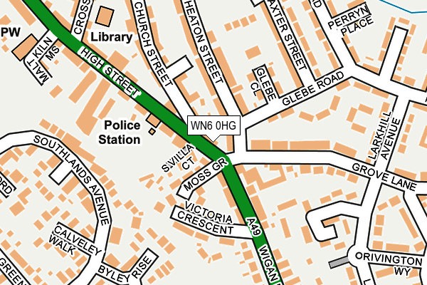
WN6 0HG lies on High Street in Standish, Wigan. WN6 0HG is located in the Standish with Langtree electoral ward, within the metropolitan district of Wigan and the English Parliamentary constituency of Wigan. The Sub Integrated Care Board (ICB) Location is NHS Greater Manchester ICB - 02H and the police force is Greater Manchester. This postcode has been in use since January 1980.


GetTheData
Source: OS OpenMap – Local (Ordnance Survey)
Source: OS VectorMap District (Ordnance Survey)
Licence: Open Government Licence (requires attribution)
| Easting | 356431 |
| Northing | 409951 |
| Latitude | 53.584325 |
| Longitude | -2.659591 |
GetTheData
Source: Open Postcode Geo
Licence: Open Government Licence
| Street | High Street |
| Locality | Standish |
| Town/City | Wigan |
| Country | England |
| Postcode District | WN6 |
➜ See where WN6 is on a map ➜ Where is Standish? | |
GetTheData
Source: Land Registry Price Paid Data
Licence: Open Government Licence
Elevation or altitude of WN6 0HG as distance above sea level:
| Metres | Feet | |
|---|---|---|
| Elevation | 110m | 361ft |
Elevation is measured from the approximate centre of the postcode, to the nearest point on an OS contour line from OS Terrain 50, which has contour spacing of ten vertical metres.
➜ How high above sea level am I? Find the elevation of your current position using your device's GPS.
GetTheData
Source: Open Postcode Elevation
Licence: Open Government Licence
| Ward | Standish With Langtree |
| Constituency | Wigan |
GetTheData
Source: ONS Postcode Database
Licence: Open Government Licence
100, HIGH STREET, STANDISH, WIGAN, WN6 0HG 2001 2 MAR £57,500 |
GetTheData
Source: HM Land Registry Price Paid Data
Licence: Contains HM Land Registry data © Crown copyright and database right 2025. This data is licensed under the Open Government Licence v3.0.
| Grove Lane/High Street (Grove Lane) | Standish | 36m |
| High St/Police Stn (High St) | Standish | 89m |
| High St/Police Stn (High St) | Standish | 115m |
| St Wilfrid's Road (Nw Bound) (St Wilfrid's Rd) | Standish | 217m |
| St Wilfrid's Road (Sebnd) (St Wilfrid's Rd) | Standish | 236m |
| Gathurst Station | 3.6km |
| Appley Bridge Station | 4km |
| Wigan Wallgate Station | 4.7km |
GetTheData
Source: NaPTAN
Licence: Open Government Licence
GetTheData
Source: ONS Postcode Database
Licence: Open Government Licence


➜ Get more ratings from the Food Standards Agency
GetTheData
Source: Food Standards Agency
Licence: FSA terms & conditions
| Last Collection | |||
|---|---|---|---|
| Location | Mon-Fri | Sat | Distance |
| 2 Tansley Avenue, Coppull | 16:30 | 11:00 | 2,226m |
| Elmfield Road | 18:20 | 11:10 | 2,272m |
| Coppull Post Office | 17:00 | 11:00 | 2,537m |
GetTheData
Source: Dracos
Licence: Creative Commons Attribution-ShareAlike
The below table lists the International Territorial Level (ITL) codes (formerly Nomenclature of Territorial Units for Statistics (NUTS) codes) and Local Administrative Units (LAU) codes for WN6 0HG:
| ITL 1 Code | Name |
|---|---|
| TLD | North West (England) |
| ITL 2 Code | Name |
| TLD3 | Greater Manchester |
| ITL 3 Code | Name |
| TLD36 | Greater Manchester North West |
| LAU 1 Code | Name |
| E08000010 | Wigan |
GetTheData
Source: ONS Postcode Directory
Licence: Open Government Licence
The below table lists the Census Output Area (OA), Lower Layer Super Output Area (LSOA), and Middle Layer Super Output Area (MSOA) for WN6 0HG:
| Code | Name | |
|---|---|---|
| OA | E00031608 | |
| LSOA | E01006229 | Wigan 002A |
| MSOA | E02001288 | Wigan 002 |
GetTheData
Source: ONS Postcode Directory
Licence: Open Government Licence
| WN6 0HD | High Street | 59m |
| WN6 0HE | Moss Grove | 69m |
| WN6 0BD | Wigan Road | 86m |
| WN6 0BG | Wigan Road | 97m |
| WN6 0DA | Heaton Street | 100m |
| WN6 0HJ | South Villa Court | 108m |
| WN6 0JT | Church Street | 120m |
| WN6 0DD | Glebe Close | 125m |
| WN6 0ES | Grove Lane | 127m |
| WN6 0BB | Victoria Crescent | 132m |
GetTheData
Source: Open Postcode Geo; Land Registry Price Paid Data
Licence: Open Government Licence