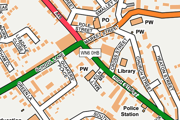
WN6 0HB is located in the Standish with Langtree electoral ward, within the metropolitan district of Wigan and the English Parliamentary constituency of Wigan. The Sub Integrated Care Board (ICB) Location is NHS Greater Manchester ICB - 02H and the police force is Greater Manchester. This postcode has been in use since January 1980.


GetTheData
Source: OS OpenMap – Local (Ordnance Survey)
Source: OS VectorMap District (Ordnance Survey)
Licence: Open Government Licence (requires attribution)
| Easting | 356166 |
| Northing | 410136 |
| Latitude | 53.585966 |
| Longitude | -2.663620 |
GetTheData
Source: Open Postcode Geo
Licence: Open Government Licence
| Country | England |
| Postcode District | WN6 |
➜ See where WN6 is on a map ➜ Where is Standish? | |
GetTheData
Source: Land Registry Price Paid Data
Licence: Open Government Licence
Elevation or altitude of WN6 0HB as distance above sea level:
| Metres | Feet | |
|---|---|---|
| Elevation | 110m | 361ft |
Elevation is measured from the approximate centre of the postcode, to the nearest point on an OS contour line from OS Terrain 50, which has contour spacing of ten vertical metres.
➜ How high above sea level am I? Find the elevation of your current position using your device's GPS.
GetTheData
Source: Open Postcode Elevation
Licence: Open Government Licence
| Ward | Standish With Langtree |
| Constituency | Wigan |
GetTheData
Source: ONS Postcode Database
Licence: Open Government Licence
| Market St/Standish Po (Market St) | Standish | 90m |
| Pole St/Standish Po (Pole St) | Standish | 106m |
| School Ln/Preston Rd (School Ln) | Standish | 115m |
| School Ln/Dog And Partridge (School Ln) | Standish | 126m |
| Preston Rd/Standish Village (Preston Rd) | Standish | 156m |
| Gathurst Station | 3.6km |
| Appley Bridge Station | 3.8km |
| Wigan Wallgate Station | 5km |
GetTheData
Source: NaPTAN
Licence: Open Government Licence
GetTheData
Source: ONS Postcode Database
Licence: Open Government Licence


➜ Get more ratings from the Food Standards Agency
GetTheData
Source: Food Standards Agency
Licence: FSA terms & conditions
| Last Collection | |||
|---|---|---|---|
| Location | Mon-Fri | Sat | Distance |
| 2 Tansley Avenue, Coppull | 16:30 | 11:00 | 1,913m |
| Coppull Post Office | 17:00 | 11:00 | 2,284m |
| Elmfield Road | 18:20 | 11:10 | 2,585m |
GetTheData
Source: Dracos
Licence: Creative Commons Attribution-ShareAlike
The below table lists the International Territorial Level (ITL) codes (formerly Nomenclature of Territorial Units for Statistics (NUTS) codes) and Local Administrative Units (LAU) codes for WN6 0HB:
| ITL 1 Code | Name |
|---|---|
| TLD | North West (England) |
| ITL 2 Code | Name |
| TLD3 | Greater Manchester |
| ITL 3 Code | Name |
| TLD36 | Greater Manchester North West |
| LAU 1 Code | Name |
| E08000010 | Wigan |
GetTheData
Source: ONS Postcode Directory
Licence: Open Government Licence
The below table lists the Census Output Area (OA), Lower Layer Super Output Area (LSOA), and Middle Layer Super Output Area (MSOA) for WN6 0HB:
| Code | Name | |
|---|---|---|
| OA | E00031609 | |
| LSOA | E01006229 | Wigan 002A |
| MSOA | E02001288 | Wigan 002 |
GetTheData
Source: ONS Postcode Directory
Licence: Open Government Licence
| WN6 0HA | High Street | 16m |
| WN6 0HL | High Street | 32m |
| WN6 0HQ | Cross Street | 72m |
| WN6 0HW | Market Street | 81m |
| WN6 0GJ | Malt Kiln Mews | 87m |
| WN6 0HR | Preston Road | 97m |
| WN6 0TQ | Quakers Place | 102m |
| WN6 0HN | Market Street | 116m |
| WN6 0HP | Pole Street | 127m |
| WN6 0HF | High Street | 146m |
GetTheData
Source: Open Postcode Geo; Land Registry Price Paid Data
Licence: Open Government Licence