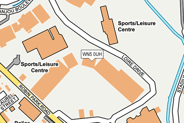
WN5 0UH lies on Loire Drive in Wigan. WN5 0UH is located in the Douglas electoral ward, within the metropolitan district of Wigan and the English Parliamentary constituency of Wigan. The Sub Integrated Care Board (ICB) Location is NHS Greater Manchester ICB - 02H and the police force is Greater Manchester. This postcode has been in use since December 1996.


GetTheData
Source: OS OpenMap – Local (Ordnance Survey)
Source: OS VectorMap District (Ordnance Survey)
Licence: Open Government Licence (requires attribution)
| Easting | 356805 |
| Northing | 405478 |
| Latitude | 53.544169 |
| Longitude | -2.653322 |
GetTheData
Source: Open Postcode Geo
Licence: Open Government Licence
| Street | Loire Drive |
| Town/City | Wigan |
| Country | England |
| Postcode District | WN5 |
➜ See where WN5 is on a map ➜ Where is Wigan? | |
GetTheData
Source: Land Registry Price Paid Data
Licence: Open Government Licence
Elevation or altitude of WN5 0UH as distance above sea level:
| Metres | Feet | |
|---|---|---|
| Elevation | 20m | 66ft |
Elevation is measured from the approximate centre of the postcode, to the nearest point on an OS contour line from OS Terrain 50, which has contour spacing of ten vertical metres.
➜ How high above sea level am I? Find the elevation of your current position using your device's GPS.
GetTheData
Source: Open Postcode Elevation
Licence: Open Government Licence
| Ward | Douglas |
| Constituency | Wigan |
GetTheData
Source: ONS Postcode Database
Licence: Open Government Licence
| Robin Pk Complex/Retail Pk (Internal Rd) | Robin Park | 75m |
| Loire Dr/Asda (Loire Dr) | Robin Park | 109m |
| Loire Dr/Asda (Loire Dr) | Robin Park | 118m |
| Robin Park Rd/Asda (Robin Park Rd) | Laithwaite | 207m |
| Robin Park Rd/Asda (Robin Park Rd) | Laithwaite | 244m |
| Wigan North Western Station | 1.3km |
| Wigan Wallgate Station | 1.3km |
| Pemberton Station | 1.9km |
GetTheData
Source: NaPTAN
Licence: Open Government Licence
| Median download speed | 8.8Mbps |
| Average download speed | 14.4Mbps |
| Maximum download speed | 38.86Mbps |
| Median upload speed | 1.0Mbps |
| Average upload speed | 3.4Mbps |
| Maximum upload speed | 8.04Mbps |
GetTheData
Source: Ofcom
Licence: Ofcom Terms of Use (requires attribution)
GetTheData
Source: ONS Postcode Database
Licence: Open Government Licence


➜ Get more ratings from the Food Standards Agency
GetTheData
Source: Food Standards Agency
Licence: FSA terms & conditions
| Last Collection | |||
|---|---|---|---|
| Location | Mon-Fri | Sat | Distance |
| Worsley Hall P O | 17:15 | 12:15 | 851m |
| Wigan Delivery Office | 19:15 | 12:40 | 1,232m |
| Wigan Branch Office | 19:05 | 12:30 | 1,397m |
GetTheData
Source: Dracos
Licence: Creative Commons Attribution-ShareAlike
| Risk of WN5 0UH flooding from rivers and sea | Very Low |
| ➜ WN5 0UH flood map | |
GetTheData
Source: Open Flood Risk by Postcode
Licence: Open Government Licence
The below table lists the International Territorial Level (ITL) codes (formerly Nomenclature of Territorial Units for Statistics (NUTS) codes) and Local Administrative Units (LAU) codes for WN5 0UH:
| ITL 1 Code | Name |
|---|---|
| TLD | North West (England) |
| ITL 2 Code | Name |
| TLD3 | Greater Manchester |
| ITL 3 Code | Name |
| TLD36 | Greater Manchester North West |
| LAU 1 Code | Name |
| E08000010 | Wigan |
GetTheData
Source: ONS Postcode Directory
Licence: Open Government Licence
The below table lists the Census Output Area (OA), Lower Layer Super Output Area (LSOA), and Middle Layer Super Output Area (MSOA) for WN5 0UH:
| Code | Name | |
|---|---|---|
| OA | E00032202 | |
| LSOA | E01006352 | Wigan 015B |
| MSOA | E02001301 | Wigan 015 |
GetTheData
Source: ONS Postcode Directory
Licence: Open Government Licence
| WN5 0AT | Chancery Close | 149m |
| WN5 0AP | Thomas More Gardens | 192m |
| WN5 0AS | More Street | 202m |
| WN5 0BH | Satchel Close | 246m |
| WN5 0UR | Laurus Mews | 272m |
| WN5 0UF | Laurel Street | 273m |
| WN5 0AR | Thomas Street | 278m |
| WN5 0UB | Scot Lane | 286m |
| WN5 0UA | Scot Lane | 301m |
| WN5 0UE | Scot Lane | 303m |
GetTheData
Source: Open Postcode Geo; Land Registry Price Paid Data
Licence: Open Government Licence