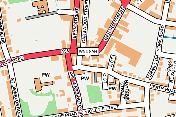
WN4 9AH is located in the Ashton-in-Makerfield South electoral ward, within the metropolitan district of Wigan and the English Parliamentary constituency of Makerfield. The Sub Integrated Care Board (ICB) Location is NHS Greater Manchester ICB - 02H and the police force is Greater Manchester. This postcode has been in use since January 1980.


GetTheData
Source: OS OpenMap – Local (Ordnance Survey)
Source: OS VectorMap District (Ordnance Survey)
Licence: Open Government Licence (requires attribution)
| Easting | 357735 |
| Northing | 399002 |
| Latitude | 53.486025 |
| Longitude | -2.638413 |
GetTheData
Source: Open Postcode Geo
Licence: Open Government Licence
| Country | England |
| Postcode District | WN4 |
➜ See where WN4 is on a map ➜ Where is Ashton-in-Makerfield? | |
GetTheData
Source: Land Registry Price Paid Data
Licence: Open Government Licence
Elevation or altitude of WN4 9AH as distance above sea level:
| Metres | Feet | |
|---|---|---|
| Elevation | 50m | 164ft |
Elevation is measured from the approximate centre of the postcode, to the nearest point on an OS contour line from OS Terrain 50, which has contour spacing of ten vertical metres.
➜ How high above sea level am I? Find the elevation of your current position using your device's GPS.
GetTheData
Source: Open Postcode Elevation
Licence: Open Government Licence
| Ward | Ashton-in-makerfield South |
| Constituency | Makerfield |
GetTheData
Source: ONS Postcode Database
Licence: Open Government Licence
| Warrington Rd/St Thomas Church (Warrington Rd) | Ashton In Makerfield | 74m |
| Warrington Rd/St Thomas Church (Warrington Rd) | Ashton In Makerfield | 76m |
| Liverpool Rd/Warrington Rd (Liverpool Rd) | Ashton In Makerfield | 124m |
| Gerard St/Ashton Town Ctr (Gerard St) | Ashton In Makerfield | 136m |
| Gerard St/Ashton Town Ctr (Gerard St) | Ashton In Makerfield | 157m |
| Bryn Station | 1.6km |
| Garswood Station | 2.3km |
| Earlestown Station | 3.9km |
GetTheData
Source: NaPTAN
Licence: Open Government Licence
GetTheData
Source: ONS Postcode Database
Licence: Open Government Licence


➜ Get more ratings from the Food Standards Agency
GetTheData
Source: Food Standards Agency
Licence: FSA terms & conditions
| Last Collection | |||
|---|---|---|---|
| Location | Mon-Fri | Sat | Distance |
| Ashton P O | 19:00 | 12:00 | 214m |
| Ashton P O | 19:00 | 12:00 | 239m |
| Bridgefoot | 18:55 | 11:25 | 250m |
GetTheData
Source: Dracos
Licence: Creative Commons Attribution-ShareAlike
The below table lists the International Territorial Level (ITL) codes (formerly Nomenclature of Territorial Units for Statistics (NUTS) codes) and Local Administrative Units (LAU) codes for WN4 9AH:
| ITL 1 Code | Name |
|---|---|
| TLD | North West (England) |
| ITL 2 Code | Name |
| TLD3 | Greater Manchester |
| ITL 3 Code | Name |
| TLD36 | Greater Manchester North West |
| LAU 1 Code | Name |
| E08000010 | Wigan |
GetTheData
Source: ONS Postcode Directory
Licence: Open Government Licence
The below table lists the Census Output Area (OA), Lower Layer Super Output Area (LSOA), and Middle Layer Super Output Area (MSOA) for WN4 9AH:
| Code | Name | |
|---|---|---|
| OA | E00031552 | |
| LSOA | E01006223 | Wigan 036A |
| MSOA | E02001322 | Wigan 036 |
GetTheData
Source: ONS Postcode Directory
Licence: Open Government Licence
| WN4 9AE | Gerard Street | 57m |
| WN4 9DZ | Church Terrace | 72m |
| WN4 9PL | Warrington Road | 84m |
| WN4 9DL | Heath Road | 87m |
| WN4 9DX | A Court | 92m |
| WN4 9AG | Gerard Street | 94m |
| WN4 9DY | Heath Road | 110m |
| WN4 9EA | C Court | 115m |
| WN4 9AF | Garswood Street | 122m |
| WN4 9LH | Liverpool Road | 127m |
GetTheData
Source: Open Postcode Geo; Land Registry Price Paid Data
Licence: Open Government Licence