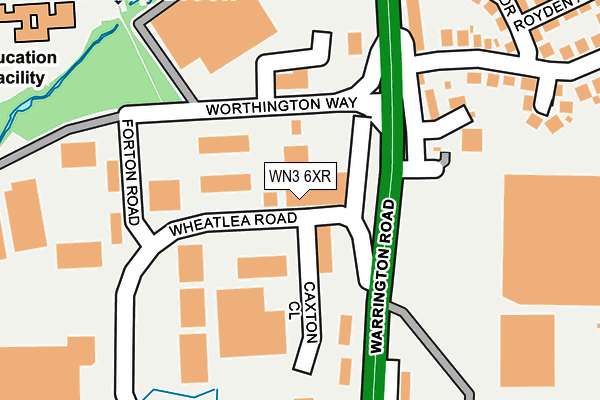
WN3 6XR is located in the Winstanley electoral ward, within the metropolitan district of Wigan and the English Parliamentary constituency of Makerfield. The Sub Integrated Care Board (ICB) Location is NHS Greater Manchester ICB - 02H and the police force is Greater Manchester. This postcode has been in use since January 1993.


GetTheData
Source: OS OpenMap – Local (Ordnance Survey)
Source: OS VectorMap District (Ordnance Survey)
Licence: Open Government Licence (requires attribution)
| Easting | 356743 |
| Northing | 402682 |
| Latitude | 53.519034 |
| Longitude | -2.653871 |
GetTheData
Source: Open Postcode Geo
Licence: Open Government Licence
| Country | England |
| Postcode District | WN3 |
➜ See where WN3 is on a map ➜ Where is Wigan? | |
GetTheData
Source: Land Registry Price Paid Data
Licence: Open Government Licence
Elevation or altitude of WN3 6XR as distance above sea level:
| Metres | Feet | |
|---|---|---|
| Elevation | 40m | 131ft |
Elevation is measured from the approximate centre of the postcode, to the nearest point on an OS contour line from OS Terrain 50, which has contour spacing of ten vertical metres.
➜ How high above sea level am I? Find the elevation of your current position using your device's GPS.
GetTheData
Source: Open Postcode Elevation
Licence: Open Government Licence
| Ward | Winstanley |
| Constituency | Makerfield |
GetTheData
Source: ONS Postcode Database
Licence: Open Government Licence
| Warrington Rd/Marus Bridge Retail Pk (Warrington Rd) | Marus Bridge | 125m |
| Fulbeck Ave/Ben Jonson Hotel (Fulbeck Ave) | Marus Bridge | 190m |
| Warrington Rd/Marus Bridge Retail Pk (Warrington Rd) | Marus Bridge | 199m |
| Highfield Grange Ave/Hope Sch (Highfld Grge Av) | Marus Bridge | 350m |
| Highfield Grange Ave/Hope Sch (Highfld Grge Av) | Marus Bridge | 361m |
| Pemberton Station | 1.7km |
| Bryn Station | 2.2km |
| Wigan North Western Station | 3.1km |
GetTheData
Source: NaPTAN
Licence: Open Government Licence
GetTheData
Source: ONS Postcode Database
Licence: Open Government Licence


➜ Get more ratings from the Food Standards Agency
GetTheData
Source: Food Standards Agency
Licence: FSA terms & conditions
| Last Collection | |||
|---|---|---|---|
| Location | Mon-Fri | Sat | Distance |
| Frederick Street | 18:00 | 11:00 | 789m |
| Hawley P O | 18:30 | 11:50 | 995m |
| Tanhouse Drive | 18:00 | 12:20 | 1,277m |
GetTheData
Source: Dracos
Licence: Creative Commons Attribution-ShareAlike
The below table lists the International Territorial Level (ITL) codes (formerly Nomenclature of Territorial Units for Statistics (NUTS) codes) and Local Administrative Units (LAU) codes for WN3 6XR:
| ITL 1 Code | Name |
|---|---|
| TLD | North West (England) |
| ITL 2 Code | Name |
| TLD3 | Greater Manchester |
| ITL 3 Code | Name |
| TLD36 | Greater Manchester North West |
| LAU 1 Code | Name |
| E08000010 | Wigan |
GetTheData
Source: ONS Postcode Directory
Licence: Open Government Licence
The below table lists the Census Output Area (OA), Lower Layer Super Output Area (LSOA), and Middle Layer Super Output Area (MSOA) for WN3 6XR:
| Code | Name | |
|---|---|---|
| OA | E00032418 | |
| LSOA | E01006403 | Wigan 021G |
| MSOA | E02001307 | Wigan 021 |
GetTheData
Source: ONS Postcode Directory
Licence: Open Government Licence
| WN3 6XA | Worthington Way | 138m |
| WN3 6XW | Hawkley Avenue | 177m |
| WN3 6XN | Warrington Road | 252m |
| WN3 6XB | Warrington Road | 271m |
| WN3 5QW | Walcot Place | 276m |
| WN3 5QX | Mayfair Drive | 278m |
| WN3 6SP | Kelvin Grove | 307m |
| WN3 5QY | Chelford Close | 314m |
| WN3 5QU | Royden Avenue | 338m |
| WN3 5QN | Fulbeck Avenue | 363m |
GetTheData
Source: Open Postcode Geo; Land Registry Price Paid Data
Licence: Open Government Licence