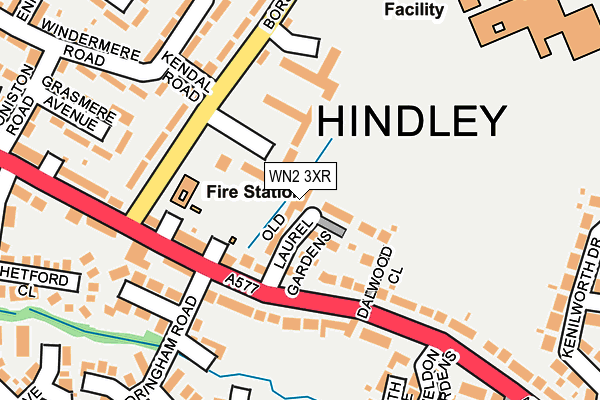
WN2 3XR is located in the Hindley Green electoral ward, within the metropolitan district of Wigan and the English Parliamentary constituency of Makerfield. The Sub Integrated Care Board (ICB) Location is NHS Greater Manchester ICB - 02H and the police force is Greater Manchester. This postcode has been in use since June 2017.


GetTheData
Source: OS OpenMap – Local (Ordnance Survey)
Source: OS VectorMap District (Ordnance Survey)
Licence: Open Government Licence (requires attribution)
| Easting | 362523 |
| Northing | 403859 |
| Latitude | 53.530059 |
| Longitude | -2.566842 |
GetTheData
Source: Open Postcode Geo
Licence: Open Government Licence
| Country | England |
| Postcode District | WN2 |
➜ See where WN2 is on a map ➜ Where is Hindley? | |
GetTheData
Source: Land Registry Price Paid Data
Licence: Open Government Licence
| Ward | Hindley Green |
| Constituency | Makerfield |
GetTheData
Source: ONS Postcode Database
Licence: Open Government Licence
| Atherton Rd/Borsdane Ave (Atherton Rd) | Hindley | 64m |
| Atherton Rd | Hindley | 187m |
| Atherton Rd/Borsdane Ave (Atherton Rd) | Hindley | 197m |
| Atherton Rd | Hindley | 229m |
| Mornington Road (Sebnd) (Mornington Road) | Castle Hill | 372m |
| Hindley Station | 1.5km |
| Ince (Manchester) Station | 3.1km |
| Daisy Hill Station | 3.5km |
GetTheData
Source: NaPTAN
Licence: Open Government Licence
| Percentage of properties with Next Generation Access | 100.0% |
| Percentage of properties with Superfast Broadband | 100.0% |
| Percentage of properties with Ultrafast Broadband | 100.0% |
| Percentage of properties with Full Fibre Broadband | 0.0% |
Superfast Broadband is between 30Mbps and 300Mbps
Ultrafast Broadband is > 300Mbps
| Median download speed | 100.0Mbps |
| Average download speed | 90.4Mbps |
| Maximum download speed | 200.00Mbps |
| Median upload speed | 9.8Mbps |
| Average upload speed | 11.3Mbps |
| Maximum upload speed | 30.03Mbps |
| Percentage of properties unable to receive 2Mbps | 0.0% |
| Percentage of properties unable to receive 5Mbps | 0.0% |
| Percentage of properties unable to receive 10Mbps | 0.0% |
| Percentage of properties unable to receive 30Mbps | 0.0% |
GetTheData
Source: Ofcom
Licence: Ofcom Terms of Use (requires attribution)
GetTheData
Source: ONS Postcode Database
Licence: Open Government Licence


➜ Get more ratings from the Food Standards Agency
GetTheData
Source: Food Standards Agency
Licence: FSA terms & conditions
| Last Collection | |||
|---|---|---|---|
| Location | Mon-Fri | Sat | Distance |
| Hindley Green P O | 18:30 | 11:55 | 629m |
| Platt Bridge P O | 18:45 | 12:05 | 1,246m |
| Belle Green Lane | 17:50 | 11:05 | 1,570m |
GetTheData
Source: Dracos
Licence: Creative Commons Attribution-ShareAlike
The below table lists the International Territorial Level (ITL) codes (formerly Nomenclature of Territorial Units for Statistics (NUTS) codes) and Local Administrative Units (LAU) codes for WN2 3XR:
| ITL 1 Code | Name |
|---|---|
| TLD | North West (England) |
| ITL 2 Code | Name |
| TLD3 | Greater Manchester |
| ITL 3 Code | Name |
| TLD36 | Greater Manchester North West |
| LAU 1 Code | Name |
| E08000010 | Wigan |
GetTheData
Source: ONS Postcode Directory
Licence: Open Government Licence
The below table lists the Census Output Area (OA), Lower Layer Super Output Area (LSOA), and Middle Layer Super Output Area (MSOA) for WN2 3XR:
| Code | Name | |
|---|---|---|
| OA | E00031842 | |
| LSOA | E01006286 | Wigan 016E |
| MSOA | E02001302 | Wigan 016 |
GetTheData
Source: ONS Postcode Directory
Licence: Open Government Licence
| WN2 3QD | Hazelmere Gardens | 75m |
| WN2 3XD | Atherton Road | 92m |
| WN2 4QB | Knaresborough Road | 164m |
| WN2 3QE | Kendal Road | 190m |
| WN2 4SW | Syderstone Close | 216m |
| WN2 3QB | Borsdane Avenue | 222m |
| WN2 4NP | Walden Close | 228m |
| WN2 4NR | Caldew Close | 230m |
| WN2 4NQ | Nene Grove | 231m |
| WN2 3QA | Grasmere Avenue | 247m |
GetTheData
Source: Open Postcode Geo; Land Registry Price Paid Data
Licence: Open Government Licence