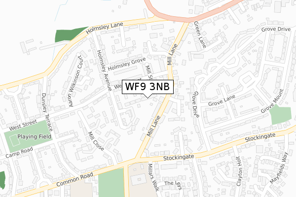
WF9 3NB is located in the South Elmsall and South Kirkby electoral ward, within the metropolitan district of Wakefield and the English Parliamentary constituency of Hemsworth. The Sub Integrated Care Board (ICB) Location is NHS West Yorkshire ICB - 03R and the police force is West Yorkshire. This postcode has been in use since September 2017.


GetTheData
Source: OS Open Zoomstack (Ordnance Survey)
Licence: Open Government Licence (requires attribution)
Attribution: Contains OS data © Crown copyright and database right 2025
Source: Open Postcode Geo
Licence: Open Government Licence (requires attribution)
Attribution: Contains OS data © Crown copyright and database right 2025; Contains Royal Mail data © Royal Mail copyright and database right 2025; Source: Office for National Statistics licensed under the Open Government Licence v.3.0
| Easting | 444416 |
| Northing | 410612 |
| Latitude | 53.590232 |
| Longitude | -1.330468 |
GetTheData
Source: Open Postcode Geo
Licence: Open Government Licence
| Country | England |
| Postcode District | WF9 |
➜ See where WF9 is on a map ➜ Where is South Kirkby? | |
GetTheData
Source: Land Registry Price Paid Data
Licence: Open Government Licence
| Ward | South Elmsall And South Kirkby |
| Constituency | Hemsworth |
GetTheData
Source: ONS Postcode Database
Licence: Open Government Licence
| Mill Lane West St (Mill Lane) | South Kirkby | 108m |
| Mill Lane West St (Mill Lane) | South Kirkby | 121m |
| Stockingate Millars Walk (Stockingate) | South Kirkby | 212m |
| Stockingate Millars Walk (Stockingate) | South Kirkby | 215m |
| Mill Lane White Apron St (Mill Lane) | South Kirkby | 236m |
| Moorthorpe Station | 1.8km |
| South Elmsall Station | 3.1km |
| Fitzwilliam Station | 5.5km |
GetTheData
Source: NaPTAN
Licence: Open Government Licence
| Percentage of properties with Next Generation Access | 100.0% |
| Percentage of properties with Superfast Broadband | 100.0% |
| Percentage of properties with Ultrafast Broadband | 0.0% |
| Percentage of properties with Full Fibre Broadband | 0.0% |
Superfast Broadband is between 30Mbps and 300Mbps
Ultrafast Broadband is > 300Mbps
| Median download speed | 39.1Mbps |
| Average download speed | 33.7Mbps |
| Maximum download speed | 39.87Mbps |
| Median upload speed | 7.4Mbps |
| Average upload speed | 6.5Mbps |
| Maximum upload speed | 8.50Mbps |
| Percentage of properties unable to receive 2Mbps | 0.0% |
| Percentage of properties unable to receive 5Mbps | 0.0% |
| Percentage of properties unable to receive 10Mbps | 0.0% |
| Percentage of properties unable to receive 30Mbps | 0.0% |
GetTheData
Source: Ofcom
Licence: Ofcom Terms of Use (requires attribution)
GetTheData
Source: ONS Postcode Database
Licence: Open Government Licence


➜ Get more ratings from the Food Standards Agency
GetTheData
Source: Food Standards Agency
Licence: FSA terms & conditions
| Last Collection | |||
|---|---|---|---|
| Location | Mon-Fri | Sat | Distance |
| The Common P.o. | 17:00 | 11:15 | 113m |
| Holmsley Lane/Dunsley Terr | 16:30 | 11:00 | 362m |
| 37 Stockingate | 16:30 | 11:00 | 378m |
GetTheData
Source: Dracos
Licence: Creative Commons Attribution-ShareAlike
The below table lists the International Territorial Level (ITL) codes (formerly Nomenclature of Territorial Units for Statistics (NUTS) codes) and Local Administrative Units (LAU) codes for WF9 3NB:
| ITL 1 Code | Name |
|---|---|
| TLE | Yorkshire and The Humber |
| ITL 2 Code | Name |
| TLE4 | West Yorkshire |
| ITL 3 Code | Name |
| TLE45 | Wakefield |
| LAU 1 Code | Name |
| E08000036 | Wakefield |
GetTheData
Source: ONS Postcode Directory
Licence: Open Government Licence
The below table lists the Census Output Area (OA), Lower Layer Super Output Area (LSOA), and Middle Layer Super Output Area (MSOA) for WF9 3NB:
| Code | Name | |
|---|---|---|
| OA | E00059874 | |
| LSOA | E01011872 | Wakefield 045D |
| MSOA | E02002482 | Wakefield 045 |
GetTheData
Source: ONS Postcode Directory
Licence: Open Government Licence
| WF9 3HL | West Street | 55m |
| WF9 3HN | Mill Street | 62m |
| WF9 3EZ | Mill Lane | 71m |
| WF9 3HF | Holmsley Avenue | 78m |
| WF9 3HR | West Street | 96m |
| WF9 3HA | Mill Lane | 109m |
| WF9 3HB | Mill Lane | 110m |
| WF9 3HS | Hoyland Terrace | 120m |
| WF9 3HH | Mill Lane | 125m |
| WF9 3HP | Holmsley Avenue | 127m |
GetTheData
Source: Open Postcode Geo; Land Registry Price Paid Data
Licence: Open Government Licence