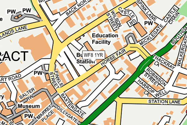
WF8 1YR is located in the Pontefract North electoral ward, within the metropolitan district of Wakefield and the English Parliamentary constituency of Normanton, Pontefract and Castleford. The Sub Integrated Care Board (ICB) Location is NHS West Yorkshire ICB - 03R and the police force is West Yorkshire. This postcode has been in use since May 2006.


GetTheData
Source: OS OpenMap – Local (Ordnance Survey)
Source: OS VectorMap District (Ordnance Survey)
Licence: Open Government Licence (requires attribution)
| Easting | 445793 |
| Northing | 422081 |
| Latitude | 53.693174 |
| Longitude | -1.307981 |
GetTheData
Source: Open Postcode Geo
Licence: Open Government Licence
| Country | England |
| Postcode District | WF8 |
➜ See where WF8 is on a map ➜ Where is Pontefract? | |
GetTheData
Source: Land Registry Price Paid Data
Licence: Open Government Licence
Elevation or altitude of WF8 1YR as distance above sea level:
| Metres | Feet | |
|---|---|---|
| Elevation | 50m | 164ft |
Elevation is measured from the approximate centre of the postcode, to the nearest point on an OS contour line from OS Terrain 50, which has contour spacing of ten vertical metres.
➜ How high above sea level am I? Find the elevation of your current position using your device's GPS.
GetTheData
Source: Open Postcode Elevation
Licence: Open Government Licence
| Ward | Pontefract North |
| Constituency | Normanton, Pontefract And Castleford |
GetTheData
Source: ONS Postcode Database
Licence: Open Government Licence
| Horsefair (Horse Fair) | Pontefract | 17m |
| Friarwood Lane Southgate (Friarwood Lane) | Pontefract | 161m |
| Northgate Spink Lane (Northgate) | Pontefract | 207m |
| Northgate Spink Lane (Northgate) | Pontefract | 212m |
| Stuart Road Swimming Baths (Stuart Road) | Pontefract | 265m |
| Pontefract Baghill Station | 0.3km |
| Pontefract Monkhill Station | 0.7km |
| Pontefract Tanshelf Station | 0.7km |
GetTheData
Source: NaPTAN
Licence: Open Government Licence
GetTheData
Source: ONS Postcode Database
Licence: Open Government Licence


➜ Get more ratings from the Food Standards Agency
GetTheData
Source: Food Standards Agency
Licence: FSA terms & conditions
| Last Collection | |||
|---|---|---|---|
| Location | Mon-Fri | Sat | Distance |
| Pontefract Delivery Office | 18:30 | 11:30 | 38m |
| Pontefract Delivery Office | 18:30 | 12:00 | 39m |
| Cornmarket | 18:30 | 12:15 | 418m |
GetTheData
Source: Dracos
Licence: Creative Commons Attribution-ShareAlike
The below table lists the International Territorial Level (ITL) codes (formerly Nomenclature of Territorial Units for Statistics (NUTS) codes) and Local Administrative Units (LAU) codes for WF8 1YR:
| ITL 1 Code | Name |
|---|---|
| TLE | Yorkshire and The Humber |
| ITL 2 Code | Name |
| TLE4 | West Yorkshire |
| ITL 3 Code | Name |
| TLE45 | Wakefield |
| LAU 1 Code | Name |
| E08000036 | Wakefield |
GetTheData
Source: ONS Postcode Directory
Licence: Open Government Licence
The below table lists the Census Output Area (OA), Lower Layer Super Output Area (LSOA), and Middle Layer Super Output Area (MSOA) for WF8 1YR:
| Code | Name | |
|---|---|---|
| OA | E00059686 | |
| LSOA | E01011838 | Wakefield 015C |
| MSOA | E02002452 | Wakefield 015 |
GetTheData
Source: ONS Postcode Directory
Licence: Open Government Licence
| WF8 1PZ | 58m | |
| WF8 1RF | Horsefair | 83m |
| WF8 1HB | Richmond Terrace | 101m |
| WF8 1PE | Horsefair | 107m |
| WF8 1PX | 111m | |
| WF8 1HD | Northgate | 117m |
| WF8 1HL | Wilson Street | 129m |
| WF8 1HJ | Northgate | 150m |
| WF8 1HE | Finkle Street | 156m |
| WF8 1PG | Bridge Street | 164m |
GetTheData
Source: Open Postcode Geo; Land Registry Price Paid Data
Licence: Open Government Licence