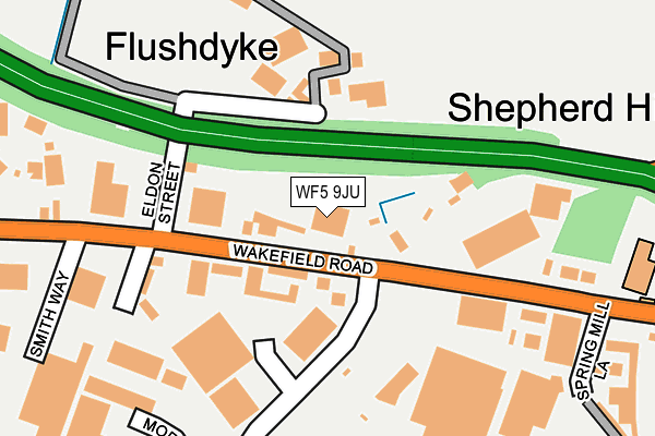
WF5 9JU is located in the Ossett electoral ward, within the metropolitan district of Wakefield and the English Parliamentary constituency of Wakefield. The Sub Integrated Care Board (ICB) Location is NHS West Yorkshire ICB - 03R and the police force is West Yorkshire. This postcode has been in use since January 1993.


GetTheData
Source: OS OpenMap – Local (Ordnance Survey)
Source: OS VectorMap District (Ordnance Survey)
Licence: Open Government Licence (requires attribution)
| Easting | 428666 |
| Northing | 421133 |
| Latitude | 53.685871 |
| Longitude | -1.567431 |
GetTheData
Source: Open Postcode Geo
Licence: Open Government Licence
| Country | England |
| Postcode District | WF5 |
➜ See where WF5 is on a map ➜ Where is Ossett? | |
GetTheData
Source: Land Registry Price Paid Data
Licence: Open Government Licence
Elevation or altitude of WF5 9JU as distance above sea level:
| Metres | Feet | |
|---|---|---|
| Elevation | 80m | 262ft |
Elevation is measured from the approximate centre of the postcode, to the nearest point on an OS contour line from OS Terrain 50, which has contour spacing of ten vertical metres.
➜ How high above sea level am I? Find the elevation of your current position using your device's GPS.
GetTheData
Source: Open Postcode Elevation
Licence: Open Government Licence
| Ward | Ossett |
| Constituency | Wakefield |
GetTheData
Source: ONS Postcode Database
Licence: Open Government Licence
| Wakefield Rd Eldon Street (Wakefield Road) | Flushdyke | 68m |
| Wakefield Rd Eldon Street (Wakefield Road) | Flushdyke | 134m |
| Wakefield Rd Milner Way (Wakefield Road) | Flushdyke | 140m |
| Wakefield Rd Spring Mill Lane (Wakefield Road) | Flushdyke | 184m |
| Milner Way | Ossett | 282m |
| Wakefield Westgate Station | 4.1km |
| Dewsbury Station | 4.4km |
| Batley Station | 4.5km |
GetTheData
Source: NaPTAN
Licence: Open Government Licence
GetTheData
Source: ONS Postcode Database
Licence: Open Government Licence


➜ Get more ratings from the Food Standards Agency
GetTheData
Source: Food Standards Agency
Licence: FSA terms & conditions
| Last Collection | |||
|---|---|---|---|
| Location | Mon-Fri | Sat | Distance |
| Flushdike | 17:00 | 11:00 | 242m |
| Flushdike School Wakefield Road | 17:30 | 11:00 | 310m |
| Wakefield Road | 17:00 | 11:00 | 536m |
GetTheData
Source: Dracos
Licence: Creative Commons Attribution-ShareAlike
The below table lists the International Territorial Level (ITL) codes (formerly Nomenclature of Territorial Units for Statistics (NUTS) codes) and Local Administrative Units (LAU) codes for WF5 9JU:
| ITL 1 Code | Name |
|---|---|
| TLE | Yorkshire and The Humber |
| ITL 2 Code | Name |
| TLE4 | West Yorkshire |
| ITL 3 Code | Name |
| TLE45 | Wakefield |
| LAU 1 Code | Name |
| E08000036 | Wakefield |
GetTheData
Source: ONS Postcode Directory
Licence: Open Government Licence
The below table lists the Census Output Area (OA), Lower Layer Super Output Area (LSOA), and Middle Layer Super Output Area (MSOA) for WF5 9JU:
| Code | Name | |
|---|---|---|
| OA | E00059649 | |
| LSOA | E01011825 | Wakefield 021C |
| MSOA | E02002458 | Wakefield 021 |
GetTheData
Source: ONS Postcode Directory
Licence: Open Government Licence
| WF5 9JX | Wakefield Road | 70m |
| WF5 9JT | St Oswalds Place | 184m |
| WF5 9AR | Wakefield Road | 222m |
| WF5 9LB | Wakefield Road | 273m |
| WF5 9JA | Wakefield Road | 322m |
| WF5 9JS | Wakefield Road | 363m |
| WF5 9AQ | Wakefield Road | 410m |
| WF5 0RF | Whitley Spring Crescent | 429m |
| WF5 9JE | Milner Way | 482m |
| WF5 0QX | Tumbling Close | 485m |
GetTheData
Source: Open Postcode Geo; Land Registry Price Paid Data
Licence: Open Government Licence