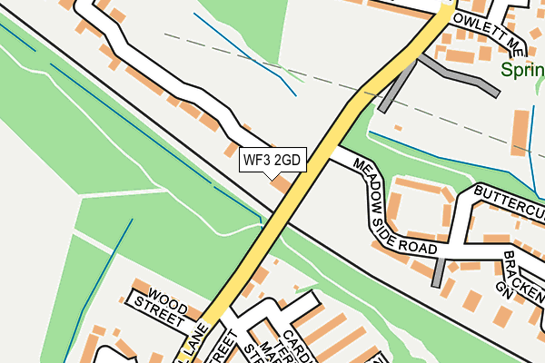
WF3 2GD is located in the Ardsley & Robin Hood electoral ward, within the metropolitan district of Leeds and the English Parliamentary constituency of Morley and Outwood. The Sub Integrated Care Board (ICB) Location is NHS West Yorkshire ICB - 15F and the police force is West Yorkshire. This postcode has been in use since February 2017.


GetTheData
Source: OS OpenMap – Local (Ordnance Survey)
Source: OS VectorMap District (Ordnance Survey)
Licence: Open Government Licence (requires attribution)
| Easting | 431048 |
| Northing | 426029 |
| Latitude | 53.729756 |
| Longitude | -1.530880 |
GetTheData
Source: Open Postcode Geo
Licence: Open Government Licence
| Country | England |
| Postcode District | WF3 |
➜ See where WF3 is on a map | |
GetTheData
Source: Land Registry Price Paid Data
Licence: Open Government Licence
| Ward | Ardsley & Robin Hood |
| Constituency | Morley And Outwood |
GetTheData
Source: ONS Postcode Database
Licence: Open Government Licence
| Mary St Cross Street (Mary Street) | East Ardsley | 159m |
| Fall Lane Queen St (Fall Lane) | East Ardsley | 329m |
| Fall Lane Queen St (Fall Lane) | East Ardsley | 329m |
| Gascoigne Road Springwood Close (Gascoigne Road) | Thorpe | 445m |
| Station Lane | Thorpe | 449m |
| Outwood Station | 2.1km |
| Morley Station | 4.6km |
| Cottingley Station | 5.7km |
GetTheData
Source: NaPTAN
Licence: Open Government Licence
| Percentage of properties with Next Generation Access | 100.0% |
| Percentage of properties with Superfast Broadband | 100.0% |
| Percentage of properties with Ultrafast Broadband | 0.0% |
| Percentage of properties with Full Fibre Broadband | 0.0% |
Superfast Broadband is between 30Mbps and 300Mbps
Ultrafast Broadband is > 300Mbps
| Median download speed | 36.7Mbps |
| Average download speed | 35.4Mbps |
| Maximum download speed | 44.55Mbps |
| Median upload speed | 6.5Mbps |
| Average upload speed | 6.5Mbps |
| Maximum upload speed | 7.74Mbps |
| Percentage of properties unable to receive 2Mbps | 0.0% |
| Percentage of properties unable to receive 5Mbps | 0.0% |
| Percentage of properties unable to receive 10Mbps | 0.0% |
| Percentage of properties unable to receive 30Mbps | 0.0% |
GetTheData
Source: Ofcom
Licence: Ofcom Terms of Use (requires attribution)
GetTheData
Source: ONS Postcode Database
Licence: Open Government Licence


➜ Get more ratings from the Food Standards Agency
GetTheData
Source: Food Standards Agency
Licence: FSA terms & conditions
| Last Collection | |||
|---|---|---|---|
| Location | Mon-Fri | Sat | Distance |
| The Fall | 17:00 | 11:15 | 166m |
| Thorpe P.o. | 17:00 | 11:15 | 455m |
| Pit Lane | 16:45 | 11:15 | 616m |
GetTheData
Source: Dracos
Licence: Creative Commons Attribution-ShareAlike
The below table lists the International Territorial Level (ITL) codes (formerly Nomenclature of Territorial Units for Statistics (NUTS) codes) and Local Administrative Units (LAU) codes for WF3 2GD:
| ITL 1 Code | Name |
|---|---|
| TLE | Yorkshire and The Humber |
| ITL 2 Code | Name |
| TLE4 | West Yorkshire |
| ITL 3 Code | Name |
| TLE42 | Leeds |
| LAU 1 Code | Name |
| E08000035 | Leeds |
GetTheData
Source: ONS Postcode Directory
Licence: Open Government Licence
The below table lists the Census Output Area (OA), Lower Layer Super Output Area (LSOA), and Middle Layer Super Output Area (MSOA) for WF3 2GD:
| Code | Name | |
|---|---|---|
| OA | E00170572 | |
| LSOA | E01011499 | Leeds 105C |
| MSOA | E02002434 | Leeds 105 |
GetTheData
Source: ONS Postcode Directory
Licence: Open Government Licence
| WF3 2BX | Fall Lane | 108m |
| WF3 2BU | Pawson Street | 153m |
| WF3 2BY | Wood Street | 177m |
| WF3 2FQ | Scampston Drive | 183m |
| WF3 2BP | Cardigan Terrace | 190m |
| WF3 2BT | Oxford Street | 197m |
| WF3 2BW | Mary Street | 205m |
| WF3 2BJ | Sarah Street | 207m |
| WF3 2LZ | Meadow Side Road | 217m |
| WF3 2BS | Simpson Street | 218m |
GetTheData
Source: Open Postcode Geo; Land Registry Price Paid Data
Licence: Open Government Licence