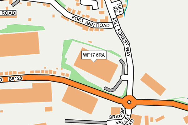
WF17 6RA lies on Mill Forest Way in Batley. WF17 6RA is located in the Batley East electoral ward, within the metropolitan district of Kirklees and the English Parliamentary constituency of Batley and Spen. The Sub Integrated Care Board (ICB) Location is NHS West Yorkshire ICB - X2C4Y and the police force is West Yorkshire. This postcode has been in use since December 1995.


GetTheData
Source: OS OpenMap – Local (Ordnance Survey)
Source: OS VectorMap District (Ordnance Survey)
Licence: Open Government Licence (requires attribution)
| Easting | 425663 |
| Northing | 423744 |
| Latitude | 53.709494 |
| Longitude | -1.612685 |
GetTheData
Source: Open Postcode Geo
Licence: Open Government Licence
| Street | Mill Forest Way |
| Town/City | Batley |
| Country | England |
| Postcode District | WF17 |
➜ See where WF17 is on a map ➜ Where is Batley? | |
GetTheData
Source: Land Registry Price Paid Data
Licence: Open Government Licence
Elevation or altitude of WF17 6RA as distance above sea level:
| Metres | Feet | |
|---|---|---|
| Elevation | 80m | 262ft |
Elevation is measured from the approximate centre of the postcode, to the nearest point on an OS contour line from OS Terrain 50, which has contour spacing of ten vertical metres.
➜ How high above sea level am I? Find the elevation of your current position using your device's GPS.
GetTheData
Source: Open Postcode Elevation
Licence: Open Government Licence
| Ward | Batley East |
| Constituency | Batley And Spen |
GetTheData
Source: ONS Postcode Database
Licence: Open Government Licence
REST ASSURED LTD, MILL FOREST WAY, BATLEY, WF17 6RA 2003 5 DEC £144,000 |
GetTheData
Source: HM Land Registry Price Paid Data
Licence: Contains HM Land Registry data © Crown copyright and database right 2025. This data is licensed under the Open Government Licence v3.0.
| Soothill Lane Laith Croft Rd (Soothill Lane) | Soothill | 469m |
| Soothill Lane Oakwood Rd (Soothill Lane) | Soothill | 484m |
| Soothill Lane Solway Rd (Soothill Lane) | Soothill | 488m |
| Grace Leather Lane Soothill Ln (Grace Leather Lane) | Soothill | 504m |
| Soothill Lane Solway Rd (Soothill Lane) | Soothill | 510m |
| Batley Station | 0.7km |
| Dewsbury Station | 2.4km |
| Morley Station | 4.7km |
GetTheData
Source: NaPTAN
Licence: Open Government Licence
GetTheData
Source: ONS Postcode Database
Licence: Open Government Licence


➜ Get more ratings from the Food Standards Agency
GetTheData
Source: Food Standards Agency
Licence: FSA terms & conditions
| Last Collection | |||
|---|---|---|---|
| Location | Mon-Fri | Sat | Distance |
| Mill Forest Way | 17:45 | 11:00 | 192m |
| Follingworth | 18:00 | 11:45 | 508m |
| 87/89 High St | 17:30 | 11:00 | 520m |
GetTheData
Source: Dracos
Licence: Creative Commons Attribution-ShareAlike
The below table lists the International Territorial Level (ITL) codes (formerly Nomenclature of Territorial Units for Statistics (NUTS) codes) and Local Administrative Units (LAU) codes for WF17 6RA:
| ITL 1 Code | Name |
|---|---|
| TLE | Yorkshire and The Humber |
| ITL 2 Code | Name |
| TLE4 | West Yorkshire |
| ITL 3 Code | Name |
| TLE44 | Calderdale and Kirklees |
| LAU 1 Code | Name |
| E08000034 | Kirklees |
GetTheData
Source: ONS Postcode Directory
Licence: Open Government Licence
The below table lists the Census Output Area (OA), Lower Layer Super Output Area (LSOA), and Middle Layer Super Output Area (MSOA) for WF17 6RA:
| Code | Name | |
|---|---|---|
| OA | E00055538 | |
| LSOA | E01011014 | Kirklees 007B |
| MSOA | E02002277 | Kirklees 007 |
GetTheData
Source: ONS Postcode Directory
Licence: Open Government Licence
| WF17 6LS | Fort Ann Road | 124m |
| WF17 6RJ | Hill Rise | 169m |
| WF17 6RB | Regent Mews | 186m |
| WF17 6LW | Grange Road | 227m |
| WF17 6RE | Heath Grove | 276m |
| WF17 6RH | Phoenix Court | 312m |
| WF17 6LQ | Willow Terrace | 327m |
| WF17 6LT | Oaks Road | 335m |
| WF17 6RD | Oaklands Drive | 341m |
| WF17 6LU | Bridle Street | 378m |
GetTheData
Source: Open Postcode Geo; Land Registry Price Paid Data
Licence: Open Government Licence