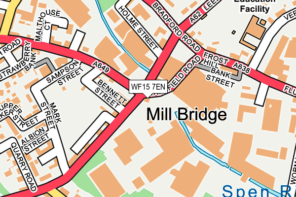
WF15 7EN lies on Huddersfield Road in Liversedge. WF15 7EN is located in the Heckmondwike electoral ward, within the metropolitan district of Kirklees and the English Parliamentary constituency of Batley and Spen. The Sub Integrated Care Board (ICB) Location is NHS West Yorkshire ICB - X2C4Y and the police force is West Yorkshire. This postcode has been in use since May 2002.


GetTheData
Source: OS OpenMap – Local (Ordnance Survey)
Source: OS VectorMap District (Ordnance Survey)
Licence: Open Government Licence (requires attribution)
| Easting | 420734 |
| Northing | 423666 |
| Latitude | 53.709026 |
| Longitude | -1.687365 |
GetTheData
Source: Open Postcode Geo
Licence: Open Government Licence
| Street | Huddersfield Road |
| Town/City | Liversedge |
| Country | England |
| Postcode District | WF15 |
➜ See where WF15 is on a map ➜ Where is Liversedge? | |
GetTheData
Source: Land Registry Price Paid Data
Licence: Open Government Licence
Elevation or altitude of WF15 7EN as distance above sea level:
| Metres | Feet | |
|---|---|---|
| Elevation | 60m | 197ft |
Elevation is measured from the approximate centre of the postcode, to the nearest point on an OS contour line from OS Terrain 50, which has contour spacing of ten vertical metres.
➜ How high above sea level am I? Find the elevation of your current position using your device's GPS.
GetTheData
Source: Open Postcode Elevation
Licence: Open Government Licence
| Ward | Heckmondwike |
| Constituency | Batley And Spen |
GetTheData
Source: ONS Postcode Database
Licence: Open Government Licence
| Halifax Rd Huddersfield Road (Halifax Road) | Liversedge | 55m |
| Halifax Road Bennett St (Halifax Road) | Liversedge | 86m |
| The Swan Ph (Bradford Road) | Liversedge | 185m |
| Sampson Street | Liversedge | 191m |
| Leeds Road Frost Hill (Leeds Road) | Liversedge | 201m |
| Dewsbury Station | 4km |
| Mirfield Station | 4.2km |
| Batley Station | 4.3km |
GetTheData
Source: NaPTAN
Licence: Open Government Licence
| Percentage of properties with Next Generation Access | 100.0% |
| Percentage of properties with Superfast Broadband | 100.0% |
| Percentage of properties with Ultrafast Broadband | 0.0% |
| Percentage of properties with Full Fibre Broadband | 0.0% |
Superfast Broadband is between 30Mbps and 300Mbps
Ultrafast Broadband is > 300Mbps
| Percentage of properties unable to receive 2Mbps | 0.0% |
| Percentage of properties unable to receive 5Mbps | 0.0% |
| Percentage of properties unable to receive 10Mbps | 0.0% |
| Percentage of properties unable to receive 30Mbps | 0.0% |
GetTheData
Source: Ofcom
Licence: Ofcom Terms of Use (requires attribution)
GetTheData
Source: ONS Postcode Database
Licence: Open Government Licence


➜ Get more ratings from the Food Standards Agency
GetTheData
Source: Food Standards Agency
Licence: FSA terms & conditions
| Last Collection | |||
|---|---|---|---|
| Location | Mon-Fri | Sat | Distance |
| The Swan | 17:30 | 11:45 | 248m |
| Union Road / Sydney St | 16:00 | 12:15 | 271m |
| 62/64 Halifax Road | 16:15 | 11:45 | 361m |
GetTheData
Source: Dracos
Licence: Creative Commons Attribution-ShareAlike
| Risk of WF15 7EN flooding from rivers and sea | Medium |
| ➜ WF15 7EN flood map | |
GetTheData
Source: Open Flood Risk by Postcode
Licence: Open Government Licence
The below table lists the International Territorial Level (ITL) codes (formerly Nomenclature of Territorial Units for Statistics (NUTS) codes) and Local Administrative Units (LAU) codes for WF15 7EN:
| ITL 1 Code | Name |
|---|---|
| TLE | Yorkshire and The Humber |
| ITL 2 Code | Name |
| TLE4 | West Yorkshire |
| ITL 3 Code | Name |
| TLE44 | Calderdale and Kirklees |
| LAU 1 Code | Name |
| E08000034 | Kirklees |
GetTheData
Source: ONS Postcode Directory
Licence: Open Government Licence
The below table lists the Census Output Area (OA), Lower Layer Super Output Area (LSOA), and Middle Layer Super Output Area (MSOA) for WF15 7EN:
| Code | Name | |
|---|---|---|
| OA | E00056669 | |
| LSOA | E01011250 | Kirklees 009D |
| MSOA | E02002279 | Kirklees 009 |
GetTheData
Source: ONS Postcode Directory
Licence: Open Government Licence
| WF15 7ET | Wharton Street | 90m |
| WF15 7ES | Bennett Street | 101m |
| WF15 6JQ | Halifax Road | 107m |
| WF15 6JN | Barker Street | 116m |
| WF15 7ER | Huddersfield Road | 148m |
| WF15 6BT | Bradford Road | 153m |
| WF15 6BJ | Bank Street | 179m |
| WF15 6JS | Spring Street | 180m |
| WF15 6JF | Holme Street | 188m |
| WF15 6BL | Wakefield Road | 194m |
GetTheData
Source: Open Postcode Geo; Land Registry Price Paid Data
Licence: Open Government Licence