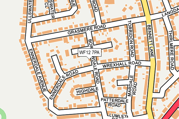
WF12 7PA lies on Borrowdale Road in Dewsbury. WF12 7PA is located in the Dewsbury East electoral ward, within the metropolitan district of Kirklees and the English Parliamentary constituency of Dewsbury. The Sub Integrated Care Board (ICB) Location is NHS West Yorkshire ICB - X2C4Y and the police force is West Yorkshire. This postcode has been in use since January 1980.


GetTheData
Source: OS OpenMap – Local (Ordnance Survey)
Source: OS VectorMap District (Ordnance Survey)
Licence: Open Government Licence (requires attribution)
| Easting | 425327 |
| Northing | 422762 |
| Latitude | 53.700684 |
| Longitude | -1.617855 |
GetTheData
Source: Open Postcode Geo
Licence: Open Government Licence
| Street | Borrowdale Road |
| Town/City | Dewsbury |
| Country | England |
| Postcode District | WF12 |
➜ See where WF12 is on a map ➜ Where is Dewsbury? | |
GetTheData
Source: Land Registry Price Paid Data
Licence: Open Government Licence
Elevation or altitude of WF12 7PA as distance above sea level:
| Metres | Feet | |
|---|---|---|
| Elevation | 130m | 427ft |
Elevation is measured from the approximate centre of the postcode, to the nearest point on an OS contour line from OS Terrain 50, which has contour spacing of ten vertical metres.
➜ How high above sea level am I? Find the elevation of your current position using your device's GPS.
GetTheData
Source: Open Postcode Elevation
Licence: Open Government Licence
| Ward | Dewsbury East |
| Constituency | Dewsbury |
GetTheData
Source: ONS Postcode Database
Licence: Open Government Licence
8, BORROWDALE ROAD, DEWSBURY, WF12 7PA 1999 21 MAY £63,000 |
GetTheData
Source: HM Land Registry Price Paid Data
Licence: Contains HM Land Registry data © Crown copyright and database right 2025. This data is licensed under the Open Government Licence v3.0.
| Bennett Lane | Hanging Heaton | 208m |
| Bennett Lane Langdale Rd (Bennett Lane) | Hanging Heaton | 226m |
| Bennett Lane Langdale Rd (Bennett Lane) | Hanging Heaton | 235m |
| Fox & Hounds Ph (Bennett Lane) | Hanging Heaton | 324m |
| Leeds Rd Bywell Road (Leeds Road) | Dewsbury | 332m |
| Batley Station | 1.1km |
| Dewsbury Station | 1.4km |
| Ravensthorpe Station | 3.7km |
GetTheData
Source: NaPTAN
Licence: Open Government Licence
| Percentage of properties with Next Generation Access | 100.0% |
| Percentage of properties with Superfast Broadband | 100.0% |
| Percentage of properties with Ultrafast Broadband | 0.0% |
| Percentage of properties with Full Fibre Broadband | 0.0% |
Superfast Broadband is between 30Mbps and 300Mbps
Ultrafast Broadband is > 300Mbps
| Percentage of properties unable to receive 2Mbps | 0.0% |
| Percentage of properties unable to receive 5Mbps | 0.0% |
| Percentage of properties unable to receive 10Mbps | 0.0% |
| Percentage of properties unable to receive 30Mbps | 0.0% |
GetTheData
Source: Ofcom
Licence: Ofcom Terms of Use (requires attribution)
GetTheData
Source: ONS Postcode Database
Licence: Open Government Licence


➜ Get more ratings from the Food Standards Agency
GetTheData
Source: Food Standards Agency
Licence: FSA terms & conditions
| Last Collection | |||
|---|---|---|---|
| Location | Mon-Fri | Sat | Distance |
| 1 Langdale Road | 17:45 | 11:00 | 276m |
| Bennett Lane | 17:30 | 12:00 | 334m |
| 87/89 High St | 17:30 | 11:00 | 534m |
GetTheData
Source: Dracos
Licence: Creative Commons Attribution-ShareAlike
The below table lists the International Territorial Level (ITL) codes (formerly Nomenclature of Territorial Units for Statistics (NUTS) codes) and Local Administrative Units (LAU) codes for WF12 7PA:
| ITL 1 Code | Name |
|---|---|
| TLE | Yorkshire and The Humber |
| ITL 2 Code | Name |
| TLE4 | West Yorkshire |
| ITL 3 Code | Name |
| TLE44 | Calderdale and Kirklees |
| LAU 1 Code | Name |
| E08000034 | Kirklees |
GetTheData
Source: ONS Postcode Directory
Licence: Open Government Licence
The below table lists the Census Output Area (OA), Lower Layer Super Output Area (LSOA), and Middle Layer Super Output Area (MSOA) for WF12 7PA:
| Code | Name | |
|---|---|---|
| OA | E00055561 | |
| LSOA | E01011022 | Kirklees 014B |
| MSOA | E02002284 | Kirklees 014 |
GetTheData
Source: ONS Postcode Directory
Licence: Open Government Licence
| WF12 7PB | Matterdale Close | 60m |
| WF12 7NQ | Ennerdale Road | 71m |
| WF12 7PF | Borrowdale Road | 72m |
| WF12 7NL | Borrowdale Road | 77m |
| WF12 7PE | Matterdale Road | 80m |
| WF12 7NY | Wrexhall Road | 92m |
| WF12 7NN | Highdale | 126m |
| WF12 7NJ | Ennerdale Crescent | 133m |
| WF12 7NX | Torridon Road | 137m |
| WF12 7NT | Lowdale | 138m |
GetTheData
Source: Open Postcode Geo; Land Registry Price Paid Data
Licence: Open Government Licence