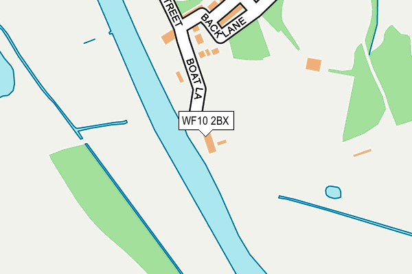
WF10 2BX lies on Main Street in Allerton Bywater, Castleford. WF10 2BX is located in the Kippax & Methley electoral ward, within the metropolitan district of Leeds and the English Parliamentary constituency of Elmet and Rothwell. The Sub Integrated Care Board (ICB) Location is NHS West Yorkshire ICB - 15F and the police force is West Yorkshire. This postcode has been in use since January 1980.


GetTheData
Source: OS OpenMap – Local (Ordnance Survey)
Source: OS VectorMap District (Ordnance Survey)
Licence: Open Government Licence (requires attribution)
| Easting | 441825 |
| Northing | 427327 |
| Latitude | 53.740655 |
| Longitude | -1.367362 |
GetTheData
Source: Open Postcode Geo
Licence: Open Government Licence
| Street | Main Street |
| Locality | Allerton Bywater |
| Town/City | Castleford |
| Country | England |
| Postcode District | WF10 |
➜ See where WF10 is on a map ➜ Where is Allerton Bywater? | |
GetTheData
Source: Land Registry Price Paid Data
Licence: Open Government Licence
Elevation or altitude of WF10 2BX as distance above sea level:
| Metres | Feet | |
|---|---|---|
| Elevation | 10m | 33ft |
Elevation is measured from the approximate centre of the postcode, to the nearest point on an OS contour line from OS Terrain 50, which has contour spacing of ten vertical metres.
➜ How high above sea level am I? Find the elevation of your current position using your device's GPS.
GetTheData
Source: Open Postcode Elevation
Licence: Open Government Licence
| Ward | Kippax & Methley |
| Constituency | Elmet And Rothwell |
GetTheData
Source: ONS Postcode Database
Licence: Open Government Licence
BOAT INN, MAIN STREET, ALLERTON BYWATER, CASTLEFORD, WF10 2BX 2007 11 MAY £52,875 |
➜ Allerton Bywater house prices
GetTheData
Source: HM Land Registry Price Paid Data
Licence: Contains HM Land Registry data © Crown copyright and database right 2025. This data is licensed under the Open Government Licence v3.0.
| Station Road Robinson St (Station Road) | Allerton Bywater | 347m |
| Station Road Robinson St (Station Road) | Allerton Bywater | 396m |
| Leeds Rd Main Street (Leeds Road) | Allerton Bywater | 549m |
| Church (Leeds Road) | Allerton Bywater | 556m |
| Station Rd Shaws Terrace (Station Road) | Allerton Bywater | 558m |
| Castleford Station | 2km |
| Glasshoughton Station | 3.9km |
| Woodlesford Station | 5.3km |
GetTheData
Source: NaPTAN
Licence: Open Government Licence
GetTheData
Source: ONS Postcode Database
Licence: Open Government Licence


➜ Get more ratings from the Food Standards Agency
GetTheData
Source: Food Standards Agency
Licence: FSA terms & conditions
| Last Collection | |||
|---|---|---|---|
| Location | Mon-Fri | Sat | Distance |
| In Wall Of 22 Main Street | 16:15 | 11:15 | 522m |
| Barnsdale Road / Park Lane | 16:15 | 11:15 | 978m |
| Wilson Row/Lower Mickletown | 16:30 | 11:00 | 1,127m |
GetTheData
Source: Dracos
Licence: Creative Commons Attribution-ShareAlike
| Risk of WF10 2BX flooding from rivers and sea | Low |
| ➜ WF10 2BX flood map | |
GetTheData
Source: Open Flood Risk by Postcode
Licence: Open Government Licence
The below table lists the International Territorial Level (ITL) codes (formerly Nomenclature of Territorial Units for Statistics (NUTS) codes) and Local Administrative Units (LAU) codes for WF10 2BX:
| ITL 1 Code | Name |
|---|---|
| TLE | Yorkshire and The Humber |
| ITL 2 Code | Name |
| TLE4 | West Yorkshire |
| ITL 3 Code | Name |
| TLE42 | Leeds |
| LAU 1 Code | Name |
| E08000035 | Leeds |
GetTheData
Source: ONS Postcode Directory
Licence: Open Government Licence
The below table lists the Census Output Area (OA), Lower Layer Super Output Area (LSOA), and Middle Layer Super Output Area (MSOA) for WF10 2BX:
| Code | Name | |
|---|---|---|
| OA | E00170568 | |
| LSOA | E01011299 | Leeds 088B |
| MSOA | E02002417 | Leeds 088 |
GetTheData
Source: ONS Postcode Directory
Licence: Open Government Licence
| WF10 2PG | Back Lane | 139m |
| WF10 2BY | Providence Place | 157m |
| WF10 2BU | Robinson Street | 210m |
| WF10 2DA | Main Street | 229m |
| WF10 2DF | Victoria Street | 265m |
| WF10 2BT | Robinson Street | 298m |
| WF10 2BN | Back Lane | 306m |
| WF10 2DG | Victoria Close | 309m |
| WF10 2BP | Station Road | 367m |
| WF10 2DQ | Whitley Place | 375m |
GetTheData
Source: Open Postcode Geo; Land Registry Price Paid Data
Licence: Open Government Licence