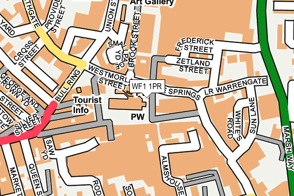
WF1 1PR is located in the Wakefield North electoral ward, within the metropolitan district of Wakefield and the English Parliamentary constituency of Wakefield. The Sub Integrated Care Board (ICB) Location is NHS West Yorkshire ICB - 03R and the police force is West Yorkshire. This postcode has been in use since January 1980.


GetTheData
Source: OS OpenMap – Local (Ordnance Survey)
Source: OS VectorMap District (Ordnance Survey)
Licence: Open Government Licence (requires attribution)
| Easting | 433373 |
| Northing | 420852 |
| Latitude | 53.683083 |
| Longitude | -1.496196 |
GetTheData
Source: Open Postcode Geo
Licence: Open Government Licence
| Country | England |
| Postcode District | WF1 |
➜ See where WF1 is on a map ➜ Where is Wakefield? | |
GetTheData
Source: Land Registry Price Paid Data
Licence: Open Government Licence
Elevation or altitude of WF1 1PR as distance above sea level:
| Metres | Feet | |
|---|---|---|
| Elevation | 40m | 131ft |
Elevation is measured from the approximate centre of the postcode, to the nearest point on an OS contour line from OS Terrain 50, which has contour spacing of ten vertical metres.
➜ How high above sea level am I? Find the elevation of your current position using your device's GPS.
GetTheData
Source: Open Postcode Elevation
Licence: Open Government Licence
| Ward | Wakefield North |
| Constituency | Wakefield |
GetTheData
Source: ONS Postcode Database
Licence: Open Government Licence
| The Springs | Wakefield City Centre | 31m |
| Westmorland Street | Wakefield City Centre | 47m |
| The Springs | Wakefield City Centre | 52m |
| Kirkgate | Wakefield City Centre | 125m |
| Almshouse Lane Ridings (Almshouse Lane) | Wakefield City Centre | 132m |
| Wakefield Westgate Station | 0.7km |
| Wakefield Kirkgate Station | 0.7km |
| Sandal & Agbrigg Station | 2.4km |
GetTheData
Source: NaPTAN
Licence: Open Government Licence
| Percentage of properties with Next Generation Access | 100.0% |
| Percentage of properties with Superfast Broadband | 100.0% |
| Percentage of properties with Ultrafast Broadband | 100.0% |
| Percentage of properties with Full Fibre Broadband | 0.0% |
Superfast Broadband is between 30Mbps and 300Mbps
Ultrafast Broadband is > 300Mbps
| Percentage of properties unable to receive 2Mbps | 0.0% |
| Percentage of properties unable to receive 5Mbps | 0.0% |
| Percentage of properties unable to receive 10Mbps | 0.0% |
| Percentage of properties unable to receive 30Mbps | 0.0% |
GetTheData
Source: Ofcom
Licence: Ofcom Terms of Use (requires attribution)
GetTheData
Source: ONS Postcode Database
Licence: Open Government Licence


➜ Get more ratings from the Food Standards Agency
GetTheData
Source: Food Standards Agency
Licence: FSA terms & conditions
| Last Collection | |||
|---|---|---|---|
| Location | Mon-Fri | Sat | Distance |
| By Cathedral Exit In Precinct | 18:30 | 12:30 | 110m |
| Kirkgate | 18:30 | 12:00 | 194m |
| Wakefield P.o. | 19:00 | 12:15 | 263m |
GetTheData
Source: Dracos
Licence: Creative Commons Attribution-ShareAlike
The below table lists the International Territorial Level (ITL) codes (formerly Nomenclature of Territorial Units for Statistics (NUTS) codes) and Local Administrative Units (LAU) codes for WF1 1PR:
| ITL 1 Code | Name |
|---|---|
| TLE | Yorkshire and The Humber |
| ITL 2 Code | Name |
| TLE4 | West Yorkshire |
| ITL 3 Code | Name |
| TLE45 | Wakefield |
| LAU 1 Code | Name |
| E08000036 | Wakefield |
GetTheData
Source: ONS Postcode Directory
Licence: Open Government Licence
The below table lists the Census Output Area (OA), Lower Layer Super Output Area (LSOA), and Middle Layer Super Output Area (MSOA) for WF1 1PR:
| Code | Name | |
|---|---|---|
| OA | E00060067 | |
| LSOA | E01011916 | Wakefield 017D |
| MSOA | E02002454 | Wakefield 017 |
GetTheData
Source: ONS Postcode Directory
Licence: Open Government Licence
| WF1 1PJ | Westmorland Street | 42m |
| WF1 1QF | Teall Street | 57m |
| WF1 1PU | The Springs | 63m |
| WF1 1HS | Kirkgate | 67m |
| WF1 1SP | Kirkgate | 69m |
| WF1 1QE | The Springs | 74m |
| WF1 1TQ | Kirkgate | 95m |
| WF1 1QA | The Springs | 106m |
| WF1 1QW | Brook Street | 107m |
| WF1 1QB | The Springs | 112m |
GetTheData
Source: Open Postcode Geo; Land Registry Price Paid Data
Licence: Open Government Licence