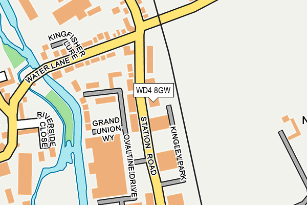
WD4 8GW is located in the Gade Valley electoral ward, within the local authority district of Three Rivers and the English Parliamentary constituency of St Albans. The Sub Integrated Care Board (ICB) Location is NHS Hertfordshire and West Essex ICB - 06N and the police force is Hertfordshire. This postcode has been in use since July 2006.


GetTheData
Source: OS OpenMap – Local (Ordnance Survey)
Source: OS VectorMap District (Ordnance Survey)
Licence: Open Government Licence (requires attribution)
| Easting | 507836 |
| Northing | 202672 |
| Latitude | 51.712432 |
| Longitude | -0.440565 |
GetTheData
Source: Open Postcode Geo
Licence: Open Government Licence
| Country | England |
| Postcode District | WD4 |
➜ See where WD4 is on a map ➜ Where is Kings Langley? | |
GetTheData
Source: Land Registry Price Paid Data
Licence: Open Government Licence
Elevation or altitude of WD4 8GW as distance above sea level:
| Metres | Feet | |
|---|---|---|
| Elevation | 80m | 262ft |
Elevation is measured from the approximate centre of the postcode, to the nearest point on an OS contour line from OS Terrain 50, which has contour spacing of ten vertical metres.
➜ How high above sea level am I? Find the elevation of your current position using your device's GPS.
GetTheData
Source: Open Postcode Elevation
Licence: Open Government Licence
| Ward | Gade Valley |
| Constituency | St Albans |
GetTheData
Source: ONS Postcode Database
Licence: Open Government Licence
UNIT 3, KINGLEY PARK, KINGS LANGLEY, WD4 8GW 2022 23 DEC £4,980,000 |
GetTheData
Source: HM Land Registry Price Paid Data
Licence: Contains HM Land Registry data © Crown copyright and database right 2025. This data is licensed under the Open Government Licence v3.0.
| Ovaltine Drive (Station Road) | Kings Langley | 26m |
| Ovaltine Drive (Station Road) | Kings Langley | 59m |
| Kingfisher Lure (Water Lane) | Kings Langley | 180m |
| Kingfisher Lure (Water Lane) | Kings Langley | 189m |
| Riverside Close (Church Lane) | Kings Langley | 285m |
| Kings Langley Station | 0.7km |
| Apsley Station | 2.7km |
| Hemel Hempstead Station | 4.8km |
GetTheData
Source: NaPTAN
Licence: Open Government Licence
GetTheData
Source: ONS Postcode Database
Licence: Open Government Licence


➜ Get more ratings from the Food Standards Agency
GetTheData
Source: Food Standards Agency
Licence: FSA terms & conditions
| Last Collection | |||
|---|---|---|---|
| Location | Mon-Fri | Sat | Distance |
| Primrose Hill | 18:30 | 338m | |
| Primrose Hill | 17:30 | 12:00 | 371m |
| Blackwell Road | 17:30 | 08:00 | 380m |
GetTheData
Source: Dracos
Licence: Creative Commons Attribution-ShareAlike
The below table lists the International Territorial Level (ITL) codes (formerly Nomenclature of Territorial Units for Statistics (NUTS) codes) and Local Administrative Units (LAU) codes for WD4 8GW:
| ITL 1 Code | Name |
|---|---|
| TLH | East |
| ITL 2 Code | Name |
| TLH2 | Bedfordshire and Hertfordshire |
| ITL 3 Code | Name |
| TLH23 | Hertfordshire CC |
| LAU 1 Code | Name |
| E07000102 | Three Rivers |
GetTheData
Source: ONS Postcode Directory
Licence: Open Government Licence
The below table lists the Census Output Area (OA), Lower Layer Super Output Area (LSOA), and Middle Layer Super Output Area (MSOA) for WD4 8GW:
| Code | Name | |
|---|---|---|
| OA | E00120900 | |
| LSOA | E01023808 | Three Rivers 001E |
| MSOA | E02004956 | Three Rivers 001 |
GetTheData
Source: ONS Postcode Directory
Licence: Open Government Licence
| WD4 8SG | Ovaltine Drive | 54m |
| WD4 8GZ | Ovaltine Drive | 115m |
| WD4 8SS | Grand Union Way | 118m |
| WD4 8GY | Ovaltine Drive | 131m |
| WD4 8GU | Ovaltine Drive | 144m |
| WD4 8TD | Hemsley Road | 151m |
| WD4 8GX | Ovaltine Drive | 157m |
| WD4 8HB | Water Lane | 159m |
| WD4 8SL | Wander Wharf | 207m |
| WD4 8HN | Water Lane | 209m |
GetTheData
Source: Open Postcode Geo; Land Registry Price Paid Data
Licence: Open Government Licence