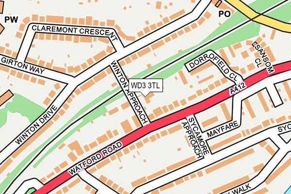
WD3 3TL is located in the Dickinsons electoral ward, within the local authority district of Three Rivers and the English Parliamentary constituency of South West Hertfordshire. The Sub Integrated Care Board (ICB) Location is NHS Hertfordshire and West Essex ICB - 06N and the police force is Hertfordshire. This postcode has been in use since January 1993.


GetTheData
Source: OS OpenMap – Local (Ordnance Survey)
Source: OS VectorMap District (Ordnance Survey)
Licence: Open Government Licence (requires attribution)
| Easting | 508360 |
| Northing | 195804 |
| Latitude | 51.650596 |
| Longitude | -0.435135 |
GetTheData
Source: Open Postcode Geo
Licence: Open Government Licence
| Country | England |
| Postcode District | WD3 |
➜ See where WD3 is on a map ➜ Where is Rickmansworth? | |
GetTheData
Source: Land Registry Price Paid Data
Licence: Open Government Licence
Elevation or altitude of WD3 3TL as distance above sea level:
| Metres | Feet | |
|---|---|---|
| Elevation | 60m | 197ft |
Elevation is measured from the approximate centre of the postcode, to the nearest point on an OS contour line from OS Terrain 50, which has contour spacing of ten vertical metres.
➜ How high above sea level am I? Find the elevation of your current position using your device's GPS.
GetTheData
Source: Open Postcode Elevation
Licence: Open Government Licence
| Ward | Dickinsons |
| Constituency | South West Hertfordshire |
GetTheData
Source: ONS Postcode Database
Licence: Open Government Licence
WINTON HOUSE, 2, WINTON APPROACH, CROXLEY GREEN, RICKMANSWORTH, WD3 3TL 2019 26 JUN £585,000 |
GetTheData
Source: HM Land Registry Price Paid Data
Licence: Contains HM Land Registry data © Crown copyright and database right 2025. This data is licensed under the Open Government Licence v3.0.
| Winton Approach (Watford Road) | Croxley Green | 55m |
| Winton Approach (Watford Road) | Croxley Green | 113m |
| Winton Drive (Baldwins Lane) | Croxley Green | 250m |
| Durrants Drive (Baldwins Lane) | Croxley Green | 269m |
| Winton Drive (Baldwins Lane) | Croxley Green | 269m |
| Croxley Underground Station | Croxley Green | 603m |
| Watford Underground Station | Watford | 1,446m |
| Rickmansworth Station | 2.9km |
| Watford High Street Station | 3km |
| Watford Junction Station | 3km |
GetTheData
Source: NaPTAN
Licence: Open Government Licence
GetTheData
Source: ONS Postcode Database
Licence: Open Government Licence


➜ Get more ratings from the Food Standards Agency
GetTheData
Source: Food Standards Agency
Licence: FSA terms & conditions
| Last Collection | |||
|---|---|---|---|
| Location | Mon-Fri | Sat | Distance |
| Links Way Croxley Green | 17:30 | 11:30 | 528m |
| Watford Road Croxley Green | 17:30 | 12:00 | 664m |
| Barton Way Croxley Green | 17:00 | 12:00 | 717m |
GetTheData
Source: Dracos
Licence: Creative Commons Attribution-ShareAlike
The below table lists the International Territorial Level (ITL) codes (formerly Nomenclature of Territorial Units for Statistics (NUTS) codes) and Local Administrative Units (LAU) codes for WD3 3TL:
| ITL 1 Code | Name |
|---|---|
| TLH | East |
| ITL 2 Code | Name |
| TLH2 | Bedfordshire and Hertfordshire |
| ITL 3 Code | Name |
| TLH23 | Hertfordshire CC |
| LAU 1 Code | Name |
| E07000102 | Three Rivers |
GetTheData
Source: ONS Postcode Directory
Licence: Open Government Licence
The below table lists the Census Output Area (OA), Lower Layer Super Output Area (LSOA), and Middle Layer Super Output Area (MSOA) for WD3 3TL:
| Code | Name | |
|---|---|---|
| OA | E00120989 | |
| LSOA | E01023825 | Three Rivers 006E |
| MSOA | E02004961 | Three Rivers 006 |
GetTheData
Source: ONS Postcode Directory
Licence: Open Government Licence
| WD3 3RY | Watford Road | 97m |
| WD3 3DE | Watford Road | 100m |
| WD3 3RF | Winton Drive | 118m |
| WD3 3TN | Sycamore Approach | 125m |
| WD3 3RB | Winton Drive | 129m |
| WD3 3RZ | Dorrofield Close | 135m |
| WD3 3RD | Winton Drive | 138m |
| WD3 3RE | Winton Drive | 149m |
| WD3 3DQ | Dorchester Court | 152m |
| WD3 3TB | Sycamore Road | 153m |
GetTheData
Source: Open Postcode Geo; Land Registry Price Paid Data
Licence: Open Government Licence