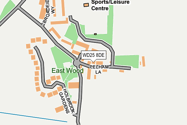
WD25 8DE lies on Pelham Lane in Aldenham, Watford. WD25 8DE is located in the Aldenham West electoral ward, within the local authority district of Hertsmere and the English Parliamentary constituency of Hertsmere. The Sub Integrated Care Board (ICB) Location is NHS Hertfordshire and West Essex ICB - 06N and the police force is Hertfordshire. This postcode has been in use since November 2005.


GetTheData
Source: OS OpenMap – Local (Ordnance Survey)
Source: OS VectorMap District (Ordnance Survey)
Licence: Open Government Licence (requires attribution)
| Easting | 513850 |
| Northing | 199225 |
| Latitude | 51.680259 |
| Longitude | -0.354702 |
GetTheData
Source: Open Postcode Geo
Licence: Open Government Licence
| Street | Pelham Lane |
| Locality | Aldenham |
| Town/City | Watford |
| Country | England |
| Postcode District | WD25 |
➜ See where WD25 is on a map ➜ Where is Aldenham? | |
GetTheData
Source: Land Registry Price Paid Data
Licence: Open Government Licence
Elevation or altitude of WD25 8DE as distance above sea level:
| Metres | Feet | |
|---|---|---|
| Elevation | 80m | 262ft |
Elevation is measured from the approximate centre of the postcode, to the nearest point on an OS contour line from OS Terrain 50, which has contour spacing of ten vertical metres.
➜ How high above sea level am I? Find the elevation of your current position using your device's GPS.
GetTheData
Source: Open Postcode Elevation
Licence: Open Government Licence
| Ward | Aldenham West |
| Constituency | Hertsmere |
GetTheData
Source: ONS Postcode Database
Licence: Open Government Licence
| St John's Church (Church Lane) | Aldenham | 691m |
| St John's Church (Church Lane) | Aldenham | 712m |
| Morgan Gardens (Church Lane) | Aldenham | 849m |
| Morgan Gardens (Church Lane) | Aldenham | 867m |
| Roundbush Lane (Radlett Road) | Round Bush | 1,008m |
| Garston (Herts) Station | 2km |
| Watford North Station | 2.5km |
| Radlett Station | 2.6km |
GetTheData
Source: NaPTAN
Licence: Open Government Licence
| Percentage of properties with Next Generation Access | 100.0% |
| Percentage of properties with Superfast Broadband | 100.0% |
| Percentage of properties with Ultrafast Broadband | 0.0% |
| Percentage of properties with Full Fibre Broadband | 0.0% |
Superfast Broadband is between 30Mbps and 300Mbps
Ultrafast Broadband is > 300Mbps
| Percentage of properties unable to receive 2Mbps | 0.0% |
| Percentage of properties unable to receive 5Mbps | 0.0% |
| Percentage of properties unable to receive 10Mbps | 0.0% |
| Percentage of properties unable to receive 30Mbps | 0.0% |
GetTheData
Source: Ofcom
Licence: Ofcom Terms of Use (requires attribution)
GetTheData
Source: ONS Postcode Database
Licence: Open Government Licence


➜ Get more ratings from the Food Standards Agency
GetTheData
Source: Food Standards Agency
Licence: FSA terms & conditions
| Last Collection | |||
|---|---|---|---|
| Location | Mon-Fri | Sat | Distance |
| Battlers Green P.o | 17:15 | 11:45 | 1,634m |
| Hanstead House Drop Lane | 17:30 | 12:00 | 1,641m |
| Gills Hill | 17:15 | 11:45 | 2,125m |
GetTheData
Source: Dracos
Licence: Creative Commons Attribution-ShareAlike
The below table lists the International Territorial Level (ITL) codes (formerly Nomenclature of Territorial Units for Statistics (NUTS) codes) and Local Administrative Units (LAU) codes for WD25 8DE:
| ITL 1 Code | Name |
|---|---|
| TLH | East |
| ITL 2 Code | Name |
| TLH2 | Bedfordshire and Hertfordshire |
| ITL 3 Code | Name |
| TLH23 | Hertfordshire CC |
| LAU 1 Code | Name |
| E07000098 | Hertsmere |
GetTheData
Source: ONS Postcode Directory
Licence: Open Government Licence
The below table lists the Census Output Area (OA), Lower Layer Super Output Area (LSOA), and Middle Layer Super Output Area (MSOA) for WD25 8DE:
| Code | Name | |
|---|---|---|
| OA | E00169757 | |
| LSOA | E01023528 | Hertsmere 010A |
| MSOA | E02004905 | Hertsmere 010 |
GetTheData
Source: ONS Postcode Directory
Licence: Open Government Licence
| WD25 8BW | Middle Down | 46m |
| WD25 8AS | Wall Hall | 88m |
| WD25 8BX | Wall Hall Drive | 94m |
| WD25 8BY | Wall Hall Drive | 123m |
| WD25 8AU | Holbrook Gardens | 182m |
| WD25 8AB | Holbrook Gardens | 187m |
| WD25 8DG | Broadfield Way | 207m |
| WD25 8DF | Broadfield Way | 242m |
| WD25 8DZ | Broadfield Way | 272m |
| WD25 8BZ | Wall Hall Drive | 312m |
GetTheData
Source: Open Postcode Geo; Land Registry Price Paid Data
Licence: Open Government Licence