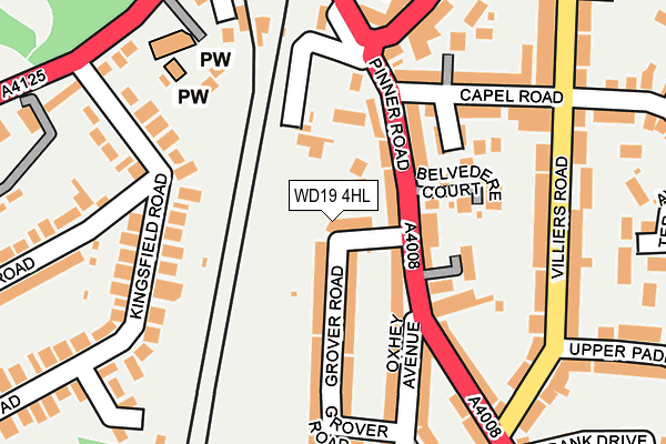
WD19 4HL lies on Grover Road in Watford. WD19 4HL is located in the Oxhey electoral ward, within the local authority district of Watford and the English Parliamentary constituency of Watford. The Sub Integrated Care Board (ICB) Location is NHS Hertfordshire and West Essex ICB - 06N and the police force is Hertfordshire. This postcode has been in use since October 2000.


GetTheData
Source: OS OpenMap – Local (Ordnance Survey)
Source: OS VectorMap District (Ordnance Survey)
Licence: Open Government Licence (requires attribution)
| Easting | 511900 |
| Northing | 195153 |
| Latitude | 51.644057 |
| Longitude | -0.384173 |
GetTheData
Source: Open Postcode Geo
Licence: Open Government Licence
| Street | Grover Road |
| Town/City | Watford |
| Country | England |
| Postcode District | WD19 |
➜ See where WD19 is on a map ➜ Where is Watford? | |
GetTheData
Source: Land Registry Price Paid Data
Licence: Open Government Licence
Elevation or altitude of WD19 4HL as distance above sea level:
| Metres | Feet | |
|---|---|---|
| Elevation | 70m | 230ft |
Elevation is measured from the approximate centre of the postcode, to the nearest point on an OS contour line from OS Terrain 50, which has contour spacing of ten vertical metres.
➜ How high above sea level am I? Find the elevation of your current position using your device's GPS.
GetTheData
Source: Open Postcode Elevation
Licence: Open Government Licence
| Ward | Oxhey |
| Constituency | Watford |
GetTheData
Source: ONS Postcode Database
Licence: Open Government Licence
| Oxhey Avenue (Pinner Road) | Bushey | 79m |
| Bushey Railway Station East (Bushey Station) | Bushey | 141m |
| Bushey Railway Station East (Pinner Road) | Bushey | 182m |
| Bushey Railway Station East (Pinner Road) | Bushey | 215m |
| Bushey Railway Station West (Eastbury Road) | Bushey | 253m |
| Bushey Station | 0.2km |
| Watford High Street Station | 1.1km |
| Carpenders Park Station | 1.8km |
GetTheData
Source: NaPTAN
Licence: Open Government Licence
| Percentage of properties with Next Generation Access | 100.0% |
| Percentage of properties with Superfast Broadband | 100.0% |
| Percentage of properties with Ultrafast Broadband | 100.0% |
| Percentage of properties with Full Fibre Broadband | 0.0% |
Superfast Broadband is between 30Mbps and 300Mbps
Ultrafast Broadband is > 300Mbps
| Percentage of properties unable to receive 2Mbps | 0.0% |
| Percentage of properties unable to receive 5Mbps | 0.0% |
| Percentage of properties unable to receive 10Mbps | 0.0% |
| Percentage of properties unable to receive 30Mbps | 0.0% |
GetTheData
Source: Ofcom
Licence: Ofcom Terms of Use (requires attribution)
GetTheData
Source: ONS Postcode Database
Licence: Open Government Licence


➜ Get more ratings from the Food Standards Agency
GetTheData
Source: Food Standards Agency
Licence: FSA terms & conditions
| Last Collection | |||
|---|---|---|---|
| Location | Mon-Fri | Sat | Distance |
| Oxhey P.o. Villiers Road | 18:30 | 12:00 | 270m |
| Bucks Avenue | 18:30 | 11:45 | 411m |
| Aldenham Road P.o | 18:30 | 12:00 | 578m |
GetTheData
Source: Dracos
Licence: Creative Commons Attribution-ShareAlike
The below table lists the International Territorial Level (ITL) codes (formerly Nomenclature of Territorial Units for Statistics (NUTS) codes) and Local Administrative Units (LAU) codes for WD19 4HL:
| ITL 1 Code | Name |
|---|---|
| TLH | East |
| ITL 2 Code | Name |
| TLH2 | Bedfordshire and Hertfordshire |
| ITL 3 Code | Name |
| TLH23 | Hertfordshire CC |
| LAU 1 Code | Name |
| E07000103 | Watford |
GetTheData
Source: ONS Postcode Directory
Licence: Open Government Licence
The below table lists the Census Output Area (OA), Lower Layer Super Output Area (LSOA), and Middle Layer Super Output Area (MSOA) for WD19 4HL:
| Code | Name | |
|---|---|---|
| OA | E00121284 | |
| LSOA | E01023882 | Watford 012A |
| MSOA | E02004979 | Watford 012 |
GetTheData
Source: ONS Postcode Directory
Licence: Open Government Licence
| WD19 4EF | Pinner Road | 59m |
| WD19 4EG | Pinner Road | 71m |
| WD19 4ED | Pinner Road | 94m |
| WD19 4HJ | Grover Road | 99m |
| WD19 4HH | Grover Road | 102m |
| WD19 4AF | Caroline Place | 126m |
| WD19 4EQ | Hillside Crescent | 127m |
| WD19 4PP | Kingsfield Road | 143m |
| WD19 4FB | Pinner Road | 144m |
| WD19 4HG | Oxhey Avenue | 145m |
GetTheData
Source: Open Postcode Geo; Land Registry Price Paid Data
Licence: Open Government Licence