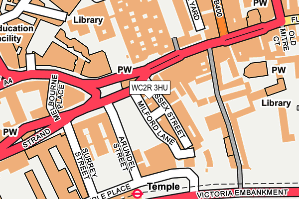
WC2R 3HU is located in the St James's electoral ward, within the London borough of Westminster and the English Parliamentary constituency of Cities of London and Westminster. The Sub Integrated Care Board (ICB) Location is NHS North West London ICB - W2U3Z and the police force is Metropolitan Police. This postcode has been in use since January 1980.


GetTheData
Source: OS OpenMap – Local (Ordnance Survey)
Source: OS VectorMap District (Ordnance Survey)
Licence: Open Government Licence (requires attribution)
| Easting | 531019 |
| Northing | 181004 |
| Latitude | 51.512778 |
| Longitude | -0.113308 |
GetTheData
Source: Open Postcode Geo
Licence: Open Government Licence
| Country | England |
| Postcode District | WC2R |
➜ See where WC2R is on a map ➜ Where is City of Westminster? | |
GetTheData
Source: Land Registry Price Paid Data
Licence: Open Government Licence
Elevation or altitude of WC2R 3HU as distance above sea level:
| Metres | Feet | |
|---|---|---|
| Elevation | 10m | 33ft |
Elevation is measured from the approximate centre of the postcode, to the nearest point on an OS contour line from OS Terrain 50, which has contour spacing of ten vertical metres.
➜ How high above sea level am I? Find the elevation of your current position using your device's GPS.
GetTheData
Source: Open Postcode Elevation
Licence: Open Government Licence
| Ward | St James's |
| Constituency | Cities Of London And Westminster |
GetTheData
Source: ONS Postcode Database
Licence: Open Government Licence
| The Royal Courts Of Justice (Strand) | Temple | 26m |
| The Royal Courts Of Justice | Temple | 84m |
| The Royal Courts Of Justice (Strand) | Temple | 101m |
| Temple | Temple | 200m |
| Aldwych Royal Cts Of Justice | Temple | 211m |
| Temple Underground Station | Temple | 208m |
| Chancery Lane Underground Station | Chancery Lane | 620m |
| Blackfriars Underground Station | Blackfriars | 683m |
| Holborn Underground Station | Holborn | 730m |
| Covent Garden Underground Station | Covent Garden | 773m |
| City Thameslink Station | 0.7km |
| London Blackfriars Station | 0.7km |
| London Charing Cross Station | 1km |
GetTheData
Source: NaPTAN
Licence: Open Government Licence
| Percentage of properties with Next Generation Access | 100.0% |
| Percentage of properties with Superfast Broadband | 100.0% |
| Percentage of properties with Ultrafast Broadband | 100.0% |
| Percentage of properties with Full Fibre Broadband | 100.0% |
Superfast Broadband is between 30Mbps and 300Mbps
Ultrafast Broadband is > 300Mbps
| Percentage of properties unable to receive 2Mbps | 0.0% |
| Percentage of properties unable to receive 5Mbps | 0.0% |
| Percentage of properties unable to receive 10Mbps | 0.0% |
| Percentage of properties unable to receive 30Mbps | 0.0% |
GetTheData
Source: Ofcom
Licence: Ofcom Terms of Use (requires attribution)
GetTheData
Source: ONS Postcode Database
Licence: Open Government Licence


➜ Get more ratings from the Food Standards Agency
GetTheData
Source: Food Standards Agency
Licence: FSA terms & conditions
| Last Collection | |||
|---|---|---|---|
| Location | Mon-Fri | Sat | Distance |
| Temple (Essex Court) | 18:30 | 12:00 | 116m |
| Aldwych (O/S 95) | 18:30 | 12:00 | 152m |
| Temple Place (Arundel St) | 18:30 | 12:00 | 160m |
GetTheData
Source: Dracos
Licence: Creative Commons Attribution-ShareAlike
The below table lists the International Territorial Level (ITL) codes (formerly Nomenclature of Territorial Units for Statistics (NUTS) codes) and Local Administrative Units (LAU) codes for WC2R 3HU:
| ITL 1 Code | Name |
|---|---|
| TLI | London |
| ITL 2 Code | Name |
| TLI3 | Inner London - West |
| ITL 3 Code | Name |
| TLI32 | Westminster |
| LAU 1 Code | Name |
| E09000033 | Westminster |
GetTheData
Source: ONS Postcode Directory
Licence: Open Government Licence
The below table lists the Census Output Area (OA), Lower Layer Super Output Area (LSOA), and Middle Layer Super Output Area (MSOA) for WC2R 3HU:
| Code | Name | |
|---|---|---|
| OA | E00023930 | |
| LSOA | E01004735 | Westminster 018B |
| MSOA | E02000977 | Westminster 018 |
GetTheData
Source: ONS Postcode Directory
Licence: Open Government Licence
| WC2R 3LL | Milford Lane | 17m |
| WC2R 3JF | Essex Street | 31m |
| WC2R 1AP | Strand | 41m |
| WC2B 4LL | Aldwych | 213m |
| WC2A 2JR | Bell Yard | 214m |
| EC4Y 1AA | Fleet Street | 223m |
| WC2A 3QS | New Square | 253m |
| EC4A 2HG | Fleet Street | 299m |
| EC4A 1BX | Fetter Lane | 316m |
| EC4A 1BY | Fetter Lane | 316m |
GetTheData
Source: Open Postcode Geo; Land Registry Price Paid Data
Licence: Open Government Licence