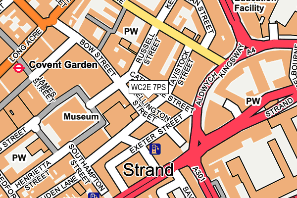
WC2E 7PS lies on Tavistock Street in London. WC2E 7PS is located in the St James's electoral ward, within the London borough of Westminster and the English Parliamentary constituency of Cities of London and Westminster. The Sub Integrated Care Board (ICB) Location is NHS North West London ICB - W2U3Z and the police force is Metropolitan Police. This postcode has been in use since June 2000.


GetTheData
Source: OS OpenMap – Local (Ordnance Survey)
Source: OS VectorMap District (Ordnance Survey)
Licence: Open Government Licence (requires attribution)
| Easting | 530528 |
| Northing | 180943 |
| Latitude | 51.512344 |
| Longitude | -0.120402 |
GetTheData
Source: Open Postcode Geo
Licence: Open Government Licence
| Street | Tavistock Street |
| Town/City | London |
| Country | England |
| Postcode District | WC2E |
➜ See where WC2E is on a map ➜ Where is City of Westminster? | |
GetTheData
Source: Land Registry Price Paid Data
Licence: Open Government Licence
Elevation or altitude of WC2E 7PS as distance above sea level:
| Metres | Feet | |
|---|---|---|
| Elevation | 20m | 66ft |
Elevation is measured from the approximate centre of the postcode, to the nearest point on an OS contour line from OS Terrain 50, which has contour spacing of ten vertical metres.
➜ How high above sea level am I? Find the elevation of your current position using your device's GPS.
GetTheData
Source: Open Postcode Elevation
Licence: Open Government Licence
| Ward | St James's |
| Constituency | Cities Of London And Westminster |
GetTheData
Source: ONS Postcode Database
Licence: Open Government Licence
| Covent Garden Russell Street | Covent Garden | 64m |
| Covent Garden Catherine Street (Catherine Street) | Covent Garden | 71m |
| Aldwych | Temple | 97m |
| Aldwych | Temple | 101m |
| Aldwych Drury Lane | Temple | 135m |
| Covent Garden Underground Station | Covent Garden | 292m |
| Temple Underground Station | Temple | 452m |
| Leicester Square Underground Station | Leicester Square | 567m |
| Holborn Underground Station | Holborn | 582m |
| Embankment Underground Station | Embankment | 609m |
| London Charing Cross Station | 0.6km |
| London Waterloo Station | 1.1km |
| City Thameslink Station | 1.2km |
GetTheData
Source: NaPTAN
Licence: Open Government Licence
| Percentage of properties with Next Generation Access | 100.0% |
| Percentage of properties with Superfast Broadband | 100.0% |
| Percentage of properties with Ultrafast Broadband | 100.0% |
| Percentage of properties with Full Fibre Broadband | 100.0% |
Superfast Broadband is between 30Mbps and 300Mbps
Ultrafast Broadband is > 300Mbps
| Percentage of properties unable to receive 2Mbps | 0.0% |
| Percentage of properties unable to receive 5Mbps | 0.0% |
| Percentage of properties unable to receive 10Mbps | 0.0% |
| Percentage of properties unable to receive 30Mbps | 0.0% |
GetTheData
Source: Ofcom
Licence: Ofcom Terms of Use (requires attribution)
Estimated total energy consumption in WC2E 7PS by fuel type, 2015.
| Consumption (kWh) | 23,657 |
|---|---|
| Meter count | 6 |
| Mean (kWh/meter) | 3,943 |
| Median (kWh/meter) | 2,052 |
GetTheData
Source: Postcode level gas estimates: 2015 (experimental)
Source: Postcode level electricity estimates: 2015 (experimental)
Licence: Open Government Licence
GetTheData
Source: ONS Postcode Database
Licence: Open Government Licence


➜ Get more ratings from the Food Standards Agency
GetTheData
Source: Food Standards Agency
Licence: FSA terms & conditions
| Last Collection | |||
|---|---|---|---|
| Location | Mon-Fri | Sat | Distance |
| Russell Street (Bow St) | 18:30 | 12:00 | 67m |
| So'ton Street (Tavistock St) | 18:30 | 12:00 | 179m |
| Savoy Street (Savoy Hill) | 18:30 | 12:00 | 196m |
GetTheData
Source: Dracos
Licence: Creative Commons Attribution-ShareAlike
The below table lists the International Territorial Level (ITL) codes (formerly Nomenclature of Territorial Units for Statistics (NUTS) codes) and Local Administrative Units (LAU) codes for WC2E 7PS:
| ITL 1 Code | Name |
|---|---|
| TLI | London |
| ITL 2 Code | Name |
| TLI3 | Inner London - West |
| ITL 3 Code | Name |
| TLI32 | Westminster |
| LAU 1 Code | Name |
| E09000033 | Westminster |
GetTheData
Source: ONS Postcode Directory
Licence: Open Government Licence
The below table lists the Census Output Area (OA), Lower Layer Super Output Area (LSOA), and Middle Layer Super Output Area (MSOA) for WC2E 7PS:
| Code | Name | |
|---|---|---|
| OA | E00023930 | |
| LSOA | E01004735 | Westminster 018B |
| MSOA | E02000977 | Westminster 018 |
GetTheData
Source: ONS Postcode Directory
Licence: Open Government Licence
| WC2B 5JS | Catherine Street | 15m |
| WC2E 7BD | Wellington Street | 21m |
| WC2E 7PB | Tavistock Street | 30m |
| WC2E 7DD | Wellington Street | 37m |
| WC2E 7NX | Tavistock Street | 50m |
| WC2E 7BN | Wellington Street | 55m |
| WC2E 7DT | Exeter Street | 67m |
| WC2E 7PZ | Burleigh Street | 76m |
| WC2B 5HZ | Russell Street | 80m |
| WC2E 7NU | Tavistock Street | 84m |
GetTheData
Source: Open Postcode Geo; Land Registry Price Paid Data
Licence: Open Government Licence