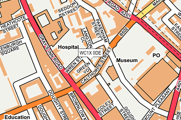
WC1X 0DE is located in the King's Cross electoral ward, within the London borough of Camden and the English Parliamentary constituency of Holborn and St Pancras. The Sub Integrated Care Board (ICB) Location is NHS North Central London ICB - 93C and the police force is Metropolitan Police. This postcode has been in use since January 1980.


GetTheData
Source: OS OpenMap – Local (Ordnance Survey)
Source: OS VectorMap District (Ordnance Survey)
Licence: Open Government Licence (requires attribution)
| Easting | 530859 |
| Northing | 182375 |
| Latitude | 51.525138 |
| Longitude | -0.115078 |
GetTheData
Source: Open Postcode Geo
Licence: Open Government Licence
| Country | England |
| Postcode District | WC1X |
➜ See where WC1X is on a map ➜ Where is London? | |
GetTheData
Source: Land Registry Price Paid Data
Licence: Open Government Licence
Elevation or altitude of WC1X 0DE as distance above sea level:
| Metres | Feet | |
|---|---|---|
| Elevation | 20m | 66ft |
Elevation is measured from the approximate centre of the postcode, to the nearest point on an OS contour line from OS Terrain 50, which has contour spacing of ten vertical metres.
➜ How high above sea level am I? Find the elevation of your current position using your device's GPS.
GetTheData
Source: Open Postcode Elevation
Licence: Open Government Licence
| Ward | King's Cross |
| Constituency | Holborn And St Pancras |
GetTheData
Source: ONS Postcode Database
Licence: Open Government Licence
| Guilford Street (Gray's Inn Road) | Bloomsbury | 89m |
| Guilford Street (Gray's Inn Road) | Bloomsbury | 134m |
| Eastman Dental Hospital (Gray's Inn Road) | Russell Square | 184m |
| Calthorpe Street (Farringdon Road) | Clerkenwell | 208m |
| Eastman Dental Hospital | Russell Square | 244m |
| Russell Square Underground Station | Russell Square | 677m |
| Chancery Lane Underground Station | Chancery Lane | 805m |
| King's Cross St. Pancras Underground Station | King's Cross | 832m |
| Farringdon Underground Station | Farringdon | 892m |
| Holborn Underground Station | Holborn | 920m |
| London Kings Cross Station | 0.8km |
| Farringdon (London) Station | 0.9km |
| London St Pancras International LL Station | 1.2km |
GetTheData
Source: NaPTAN
Licence: Open Government Licence
| Percentage of properties with Next Generation Access | 100.0% |
| Percentage of properties with Superfast Broadband | 100.0% |
| Percentage of properties with Ultrafast Broadband | 100.0% |
| Percentage of properties with Full Fibre Broadband | 0.0% |
Superfast Broadband is between 30Mbps and 300Mbps
Ultrafast Broadband is > 300Mbps
| Percentage of properties unable to receive 2Mbps | 0.0% |
| Percentage of properties unable to receive 5Mbps | 0.0% |
| Percentage of properties unable to receive 10Mbps | 0.0% |
| Percentage of properties unable to receive 30Mbps | 0.0% |
GetTheData
Source: Ofcom
Licence: Ofcom Terms of Use (requires attribution)
GetTheData
Source: ONS Postcode Database
Licence: Open Government Licence


➜ Get more ratings from the Food Standards Agency
GetTheData
Source: Food Standards Agency
Licence: FSA terms & conditions
| Last Collection | |||
|---|---|---|---|
| Location | Mon-Fri | Sat | Distance |
| Guilford Street (Doughty St) | 18:30 | 12:00 | 162m |
| Grays Inn Road (Elm St) | 18:30 | 12:00 | 265m |
| Mount Pleasant Mail Centre | 19:30 | 12:30 | 297m |
GetTheData
Source: Dracos
Licence: Creative Commons Attribution-ShareAlike
The below table lists the International Territorial Level (ITL) codes (formerly Nomenclature of Territorial Units for Statistics (NUTS) codes) and Local Administrative Units (LAU) codes for WC1X 0DE:
| ITL 1 Code | Name |
|---|---|
| TLI | London |
| ITL 2 Code | Name |
| TLI3 | Inner London - West |
| ITL 3 Code | Name |
| TLI31 | Camden and City of London |
| LAU 1 Code | Name |
| E09000007 | Camden |
GetTheData
Source: ONS Postcode Directory
Licence: Open Government Licence
The below table lists the Census Output Area (OA), Lower Layer Super Output Area (LSOA), and Middle Layer Super Output Area (MSOA) for WC1X 0DE:
| Code | Name | |
|---|---|---|
| OA | E00174661 | |
| LSOA | E01000936 | Camden 024A |
| MSOA | E02000189 | Camden 024 |
GetTheData
Source: ONS Postcode Directory
Licence: Open Government Licence
| WC1X 0JX | Calthorpe Street | 24m |
| WC1X 0JZ | Calthorpe Street | 43m |
| WC1X 0HA | Wren Street | 47m |
| WC1X 0JP | Calthorpe Street | 53m |
| WC1X 0LA | Pakenham Street | 62m |
| WC1X 8JR | Grays Inn Road | 80m |
| WC1X 0JS | Calthorpe Street | 82m |
| WC1X 0HG | Calthorpe Street | 105m |
| WC1X 8JT | Grays Inn Road | 112m |
| WC1X 8UB | Grays Inn Road | 115m |
GetTheData
Source: Open Postcode Geo; Land Registry Price Paid Data
Licence: Open Government Licence