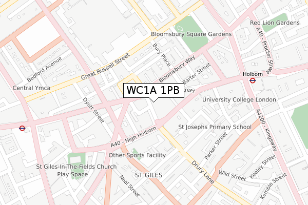
WC1A 1PB is located in the Holborn & Covent Garden electoral ward, within the London borough of Camden and the English Parliamentary constituency of Holborn and St Pancras. The Sub Integrated Care Board (ICB) Location is NHS North Central London ICB - 93C and the police force is Metropolitan Police. This postcode has been in use since July 2019.


GetTheData
Source: OS Open Zoomstack (Ordnance Survey)
Licence: Open Government Licence (requires attribution)
Attribution: Contains OS data © Crown copyright and database right 2025
Source: Open Postcode Geo
Licence: Open Government Licence (requires attribution)
Attribution: Contains OS data © Crown copyright and database right 2025; Contains Royal Mail data © Royal Mail copyright and database right 2025; Source: Office for National Statistics licensed under the Open Government Licence v.3.0
| Easting | 530218 |
| Northing | 181446 |
| Latitude | 51.516937 |
| Longitude | -0.124656 |
GetTheData
Source: Open Postcode Geo
Licence: Open Government Licence
| Country | England |
| Postcode District | WC1A |
➜ See where WC1A is on a map ➜ Where is London? | |
GetTheData
Source: Land Registry Price Paid Data
Licence: Open Government Licence
| Ward | Holborn & Covent Garden |
| Constituency | Holborn And St Pancras |
GetTheData
Source: ONS Postcode Database
Licence: Open Government Licence
| Museum Street | Holborn | 53m |
| Museum Street (Bloomsbury Way) | Holborn | 75m |
| New Oxford Street High Holborn | Holborn | 84m |
| Drury Lane (High Holborn) | Holborn | 86m |
| New Oxford Street | Tottenham Court Road | 137m |
| Holborn Underground Station | Holborn | 301m |
| Tottenham Court Road Underground Station | Tottenham Court Road | 402m |
| Covent Garden Underground Station | Covent Garden | 428m |
| Leicester Square Underground Station | Leicester Square | 670m |
| Russell Square Underground Station | Russell Square | 683m |
| London Charing Cross Station | 1km |
| Farringdon (London) Station | 1.4km |
| London Euston Station | 1.4km |
GetTheData
Source: NaPTAN
Licence: Open Government Licence
GetTheData
Source: ONS Postcode Database
Licence: Open Government Licence


➜ Get more ratings from the Food Standards Agency
GetTheData
Source: Food Standards Agency
Licence: FSA terms & conditions
| Last Collection | |||
|---|---|---|---|
| Location | Mon-Fri | Sat | Distance |
| Woburn Place (Russell Sq) | 18:30 | 12:00 | 125m |
| Bloomsbury St (New Oxford St) | 18:30 | 12:00 | 162m |
| Shaftesbury Avenue (Neal St) | 18:30 | 12:00 | 220m |
GetTheData
Source: Dracos
Licence: Creative Commons Attribution-ShareAlike
The below table lists the International Territorial Level (ITL) codes (formerly Nomenclature of Territorial Units for Statistics (NUTS) codes) and Local Administrative Units (LAU) codes for WC1A 1PB:
| ITL 1 Code | Name |
|---|---|
| TLI | London |
| ITL 2 Code | Name |
| TLI3 | Inner London - West |
| ITL 3 Code | Name |
| TLI31 | Camden and City of London |
| LAU 1 Code | Name |
| E09000007 | Camden |
GetTheData
Source: ONS Postcode Directory
Licence: Open Government Licence
The below table lists the Census Output Area (OA), Lower Layer Super Output Area (LSOA), and Middle Layer Super Output Area (MSOA) for WC1A 1PB:
| Code | Name | |
|---|---|---|
| OA | E00004560 | |
| LSOA | E01000918 | Camden 028C |
| MSOA | E02000193 | Camden 028 |
GetTheData
Source: ONS Postcode Directory
Licence: Open Government Licence
| WC1A 1BH | New Oxford Street | 37m |
| WC1A 2SE | Bloomsbury Way | 61m |
| WC1A 1JN | Museum Street | 69m |
| WC1A 1EP | New Oxford Street | 78m |
| WC1A 1JH | West Central Street | 80m |
| WC1V 7AP | High Holborn | 81m |
| WC1A 1LY | Museum Street | 88m |
| WC2H 8DX | Grape Street | 91m |
| WC1A 1NT | Coptic Street | 95m |
| WC2H 8DY | Grape Street | 105m |
GetTheData
Source: Open Postcode Geo; Land Registry Price Paid Data
Licence: Open Government Licence