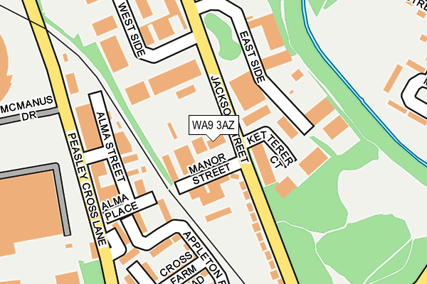
WA9 3AZ is located in the Peasley Cross & Fingerpost electoral ward, within the metropolitan district of St. Helens and the English Parliamentary constituency of St Helens South and Whiston. The Sub Integrated Care Board (ICB) Location is NHS Cheshire and Merseyside ICB - 01X and the police force is Merseyside. This postcode has been in use since August 2012.


GetTheData
Source: OS OpenMap – Local (Ordnance Survey)
Source: OS VectorMap District (Ordnance Survey)
Licence: Open Government Licence (requires attribution)
| Easting | 352253 |
| Northing | 394664 |
| Latitude | 53.446566 |
| Longitude | -2.720360 |
GetTheData
Source: Open Postcode Geo
Licence: Open Government Licence
| Country | England |
| Postcode District | WA9 |
➜ See where WA9 is on a map ➜ Where is St Helens? | |
GetTheData
Source: Land Registry Price Paid Data
Licence: Open Government Licence
Elevation or altitude of WA9 3AZ as distance above sea level:
| Metres | Feet | |
|---|---|---|
| Elevation | 30m | 98ft |
Elevation is measured from the approximate centre of the postcode, to the nearest point on an OS contour line from OS Terrain 50, which has contour spacing of ten vertical metres.
➜ How high above sea level am I? Find the elevation of your current position using your device's GPS.
GetTheData
Source: Open Postcode Elevation
Licence: Open Government Licence
| Ward | Peasley Cross & Fingerpost |
| Constituency | St Helens South And Whiston |
GetTheData
Source: ONS Postcode Database
Licence: Open Government Licence
| Manor Street (Jackson Street) | Sutton | 70m |
| Manor Street (Jackson Street) | Sutton | 113m |
| Hunter Street (Peasley Cross Lane) | Peasley Cross | 186m |
| Hunter Street (Peasley Cross Lane) | Peasley Cross | 198m |
| Beaufort Street (Sutton Road) | Peasley Cross | 280m |
| St Helens Central Station | 1km |
| St Helens Junction Station | 2km |
| Lea Green Station | 2.2km |
GetTheData
Source: NaPTAN
Licence: Open Government Licence
GetTheData
Source: ONS Postcode Database
Licence: Open Government Licence

➜ Get more ratings from the Food Standards Agency
GetTheData
Source: Food Standards Agency
Licence: FSA terms & conditions
| Last Collection | |||
|---|---|---|---|
| Location | Mon-Fri | Sat | Distance |
| Peasley Cross Post Office | 17:00 | 11:00 | 449m |
| Sorogold Street | 17:00 | 11:00 | 597m |
| Marshalls Cross | 17:30 | 11:00 | 754m |
GetTheData
Source: Dracos
Licence: Creative Commons Attribution-ShareAlike
The below table lists the International Territorial Level (ITL) codes (formerly Nomenclature of Territorial Units for Statistics (NUTS) codes) and Local Administrative Units (LAU) codes for WA9 3AZ:
| ITL 1 Code | Name |
|---|---|
| TLD | North West (England) |
| ITL 2 Code | Name |
| TLD7 | Merseyside |
| ITL 3 Code | Name |
| TLD71 | East Merseyside |
| LAU 1 Code | Name |
| E08000013 | St. Helens |
GetTheData
Source: ONS Postcode Directory
Licence: Open Government Licence
The below table lists the Census Output Area (OA), Lower Layer Super Output Area (LSOA), and Middle Layer Super Output Area (MSOA) for WA9 3AZ:
| Code | Name | |
|---|---|---|
| OA | E00035033 | |
| LSOA | E01006912 | St. Helens 019G |
| MSOA | E02001424 | St. Helens 019 |
GetTheData
Source: ONS Postcode Directory
Licence: Open Government Licence
| WA9 3BD | Jackson Street | 150m |
| WA9 3AT | Westside Industrial Estate | 218m |
| WA9 3BP | Peasley Cross Lane | 247m |
| WA9 3BN | Sutton Road | 257m |
| WA9 1QD | Monmouth Grove | 301m |
| WA9 3BE | Beaufort Street | 310m |
| WA9 1QB | Monmouth Grove | 318m |
| WA9 3BQ | Beaufort Street | 330m |
| WA9 3BL | Cleveland Street | 371m |
| WA9 1QA | Monmouth Grove | 379m |
GetTheData
Source: Open Postcode Geo; Land Registry Price Paid Data
Licence: Open Government Licence