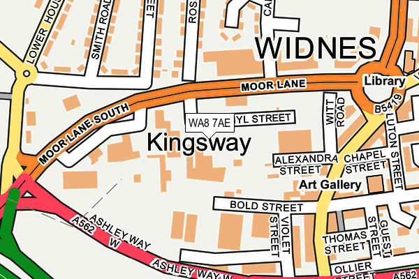
WA8 7AE is located in the Central & West Bank electoral ward, within the unitary authority of Halton and the English Parliamentary constituency of Halton. The Sub Integrated Care Board (ICB) Location is NHS Cheshire and Merseyside ICB - 01F and the police force is Cheshire. This postcode has been in use since April 1987.


GetTheData
Source: OS OpenMap – Local (Ordnance Survey)
Source: OS VectorMap District (Ordnance Survey)
Licence: Open Government Licence (requires attribution)
| Easting | 351007 |
| Northing | 385138 |
| Latitude | 53.360850 |
| Longitude | -2.737637 |
GetTheData
Source: Open Postcode Geo
Licence: Open Government Licence
| Country | England |
| Postcode District | WA8 |
➜ See where WA8 is on a map ➜ Where is Widnes? | |
GetTheData
Source: Land Registry Price Paid Data
Licence: Open Government Licence
Elevation or altitude of WA8 7AE as distance above sea level:
| Metres | Feet | |
|---|---|---|
| Elevation | 10m | 33ft |
Elevation is measured from the approximate centre of the postcode, to the nearest point on an OS contour line from OS Terrain 50, which has contour spacing of ten vertical metres.
➜ How high above sea level am I? Find the elevation of your current position using your device's GPS.
GetTheData
Source: Open Postcode Elevation
Licence: Open Government Licence
| Ward | Central & West Bank |
| Constituency | Halton |
GetTheData
Source: ONS Postcode Database
Licence: Open Government Licence
| Doctors Pub (Victoria Road) | Widnes | 197m |
| Ashley Way (Victoria Road) | Widnes | 200m |
| Kingsway Hotel (Victoria Road) | Widnes | 219m |
| Ashley Way (Victoria Road) | Widnes | 306m |
| Milton Road (Caldwell Road) | Widnes | 311m |
| Widnes Station | 2km |
| Runcorn Station | 2.5km |
| Hough Green Station | 2.8km |
GetTheData
Source: NaPTAN
Licence: Open Government Licence
GetTheData
Source: ONS Postcode Database
Licence: Open Government Licence


➜ Get more ratings from the Food Standards Agency
GetTheData
Source: Food Standards Agency
Licence: FSA terms & conditions
| Last Collection | |||
|---|---|---|---|
| Location | Mon-Fri | Sat | Distance |
| Waterloo Road | 17:30 | 11:00 | 100m |
| Head Office | 18:30 | 12:30 | 500m |
| Elliott Street | 17:30 | 11:00 | 906m |
GetTheData
Source: Dracos
Licence: Creative Commons Attribution-ShareAlike
| Risk of WA8 7AE flooding from rivers and sea | Low |
| ➜ WA8 7AE flood map | |
GetTheData
Source: Open Flood Risk by Postcode
Licence: Open Government Licence
The below table lists the International Territorial Level (ITL) codes (formerly Nomenclature of Territorial Units for Statistics (NUTS) codes) and Local Administrative Units (LAU) codes for WA8 7AE:
| ITL 1 Code | Name |
|---|---|
| TLD | North West (England) |
| ITL 2 Code | Name |
| TLD7 | Merseyside |
| ITL 3 Code | Name |
| TLD71 | East Merseyside |
| LAU 1 Code | Name |
| E06000006 | Halton |
GetTheData
Source: ONS Postcode Directory
Licence: Open Government Licence
The below table lists the Census Output Area (OA), Lower Layer Super Output Area (LSOA), and Middle Layer Super Output Area (MSOA) for WA8 7AE:
| Code | Name | |
|---|---|---|
| OA | E00062752 | |
| LSOA | E01012441 | Halton 007D |
| MSOA | E02002580 | Halton 007 |
GetTheData
Source: ONS Postcode Directory
Licence: Open Government Licence
| WA8 7AH | Alexandra Industrial Estate | 49m |
| WA8 7RY | Bold Street | 125m |
| WA8 7RU | Witt Road | 145m |
| WA8 7RP | Victoria Road | 171m |
| WA8 7RJ | Victoria Road | 200m |
| WA8 7RS | Victoria Road | 209m |
| WA8 7RA | Victoria Road | 210m |
| WA8 7JX | Millar Crescent | 211m |
| WA8 7AP | Moor Lane | 215m |
| WA8 7AT | Egypt Street | 236m |
GetTheData
Source: Open Postcode Geo; Land Registry Price Paid Data
Licence: Open Government Licence