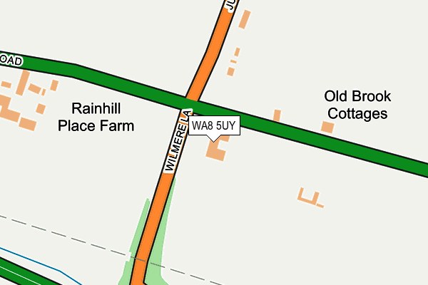
WA8 5UY lies on Wilmere Lane in Widnes. WA8 5UY is located in the Birchfield electoral ward, within the unitary authority of Halton and the English Parliamentary constituency of Halton. The Sub Integrated Care Board (ICB) Location is NHS Cheshire and Merseyside ICB - 01F and the police force is Cheshire. This postcode has been in use since October 2009.


GetTheData
Source: OS OpenMap – Local (Ordnance Survey)
Source: OS VectorMap District (Ordnance Survey)
Licence: Open Government Licence (requires attribution)
| Easting | 351305 |
| Northing | 389506 |
| Latitude | 53.400120 |
| Longitude | -2.733833 |
GetTheData
Source: Open Postcode Geo
Licence: Open Government Licence
| Street | Wilmere Lane |
| Town/City | Widnes |
| Country | England |
| Postcode District | WA8 |
➜ See where WA8 is on a map | |
GetTheData
Source: Land Registry Price Paid Data
Licence: Open Government Licence
Elevation or altitude of WA8 5UY as distance above sea level:
| Metres | Feet | |
|---|---|---|
| Elevation | 50m | 164ft |
Elevation is measured from the approximate centre of the postcode, to the nearest point on an OS contour line from OS Terrain 50, which has contour spacing of ten vertical metres.
➜ How high above sea level am I? Find the elevation of your current position using your device's GPS.
GetTheData
Source: Open Postcode Elevation
Licence: Open Government Licence
| Ward | Birchfield |
| Constituency | Halton |
GetTheData
Source: ONS Postcode Database
Licence: Open Government Licence
| County Boundary (Wilmere Lane) | Bold Heath | 60m |
| County Boundary (Wilmere Lane) | Bold Heath | 66m |
| Wilmere House (Wilmere Lane) | Barrows Green | 75m |
| Warrington Road (Jubits Lane) | Bold Heath | 98m |
| Wilmere House (Wilmere Lane) | Upton Rocks | 105m |
| Widnes Station | 2.4km |
| Rainhill Station | 2.9km |
| Lea Green Station | 3km |
GetTheData
Source: NaPTAN
Licence: Open Government Licence
| Percentage of properties with Next Generation Access | 100.0% |
| Percentage of properties with Superfast Broadband | 0.0% |
| Percentage of properties with Ultrafast Broadband | 0.0% |
| Percentage of properties with Full Fibre Broadband | 0.0% |
Superfast Broadband is between 30Mbps and 300Mbps
Ultrafast Broadband is > 300Mbps
| Percentage of properties unable to receive 2Mbps | 0.0% |
| Percentage of properties unable to receive 5Mbps | 0.0% |
| Percentage of properties unable to receive 10Mbps | 0.0% |
| Percentage of properties unable to receive 30Mbps | 100.0% |
GetTheData
Source: Ofcom
Licence: Ofcom Terms of Use (requires attribution)
GetTheData
Source: ONS Postcode Database
Licence: Open Government Licence


➜ Get more ratings from the Food Standards Agency
GetTheData
Source: Food Standards Agency
Licence: FSA terms & conditions
| Last Collection | |||
|---|---|---|---|
| Location | Mon-Fri | Sat | Distance |
| Blackhorse Post Office | 18:00 | 12:00 | 1,353m |
| Beaconsfield | 17:15 | 11:00 | 2,146m |
| Farnworth S.o. | 17:15 | 12:00 | 2,169m |
GetTheData
Source: Dracos
Licence: Creative Commons Attribution-ShareAlike
The below table lists the International Territorial Level (ITL) codes (formerly Nomenclature of Territorial Units for Statistics (NUTS) codes) and Local Administrative Units (LAU) codes for WA8 5UY:
| ITL 1 Code | Name |
|---|---|
| TLD | North West (England) |
| ITL 2 Code | Name |
| TLD7 | Merseyside |
| ITL 3 Code | Name |
| TLD71 | East Merseyside |
| LAU 1 Code | Name |
| E06000006 | Halton |
GetTheData
Source: ONS Postcode Directory
Licence: Open Government Licence
The below table lists the Census Output Area (OA), Lower Layer Super Output Area (LSOA), and Middle Layer Super Output Area (MSOA) for WA8 5UY:
| Code | Name | |
|---|---|---|
| OA | E00062526 | |
| LSOA | E01012393 | Halton 001B |
| MSOA | E02002574 | Halton 001 |
GetTheData
Source: ONS Postcode Directory
Licence: Open Government Licence
| WA8 5UX | Warrington Road | 164m |
| WA8 5UZ | Jubits Lane | 259m |
| WA8 5UP | Wilmere Lane | 481m |
| L35 6PG | Warrington Road | 540m |
| WA8 5AE | Connaught Crescent | 740m |
| WA8 5UR | Wilmere Lane | 795m |
| WA8 5AB | King Oswald Crescent | 821m |
| WA8 5AL | Nickleford Hall Drive | 849m |
| WA8 5BN | Stromford Close | 849m |
| WA8 5AH | Lindisfarne Court | 856m |
GetTheData
Source: Open Postcode Geo; Land Registry Price Paid Data
Licence: Open Government Licence