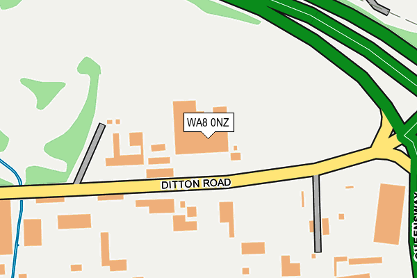
WA8 0NZ is located in the Central & West Bank electoral ward, within the unitary authority of Halton and the English Parliamentary constituency of Halton. The Sub Integrated Care Board (ICB) Location is NHS Cheshire and Merseyside ICB - 01F and the police force is Cheshire. This postcode has been in use since February 1990.


GetTheData
Source: OS OpenMap – Local (Ordnance Survey)
Source: OS VectorMap District (Ordnance Survey)
Licence: Open Government Licence (requires attribution)
| Easting | 350325 |
| Northing | 384961 |
| Latitude | 53.359195 |
| Longitude | -2.747856 |
GetTheData
Source: Open Postcode Geo
Licence: Open Government Licence
| Country | England |
| Postcode District | WA8 |
➜ See where WA8 is on a map ➜ Where is Widnes? | |
GetTheData
Source: Land Registry Price Paid Data
Licence: Open Government Licence
Elevation or altitude of WA8 0NZ as distance above sea level:
| Metres | Feet | |
|---|---|---|
| Elevation | 10m | 33ft |
Elevation is measured from the approximate centre of the postcode, to the nearest point on an OS contour line from OS Terrain 50, which has contour spacing of ten vertical metres.
➜ How high above sea level am I? Find the elevation of your current position using your device's GPS.
GetTheData
Source: Open Postcode Elevation
Licence: Open Government Licence
| Ward | Central & West Bank |
| Constituency | Halton |
GetTheData
Source: ONS Postcode Database
Licence: Open Government Licence
| Mckechnies (Ditton Road) | Ditton Marsh | 101m |
| Mckechnies (Ditton Road) | Ditton Marsh | 137m |
| Alcan (Ditton Road) | Ditton Marsh | 371m |
| Alcan (Ditton Road) | Ditton Marsh | 373m |
| Lower House Lane (Dundalk Road) | Widnes | 508m |
| Hough Green Station | 2.3km |
| Runcorn Station | 2.4km |
| Widnes Station | 2.4km |
GetTheData
Source: NaPTAN
Licence: Open Government Licence
GetTheData
Source: ONS Postcode Database
Licence: Open Government Licence


➜ Get more ratings from the Food Standards Agency
GetTheData
Source: Food Standards Agency
Licence: FSA terms & conditions
| Last Collection | |||
|---|---|---|---|
| Location | Mon-Fri | Sat | Distance |
| Waterloo Road | 17:30 | 11:00 | 756m |
| Head Office | 18:30 | 12:30 | 1,194m |
| Elliott Street | 17:30 | 11:00 | 1,550m |
GetTheData
Source: Dracos
Licence: Creative Commons Attribution-ShareAlike
The below table lists the International Territorial Level (ITL) codes (formerly Nomenclature of Territorial Units for Statistics (NUTS) codes) and Local Administrative Units (LAU) codes for WA8 0NZ:
| ITL 1 Code | Name |
|---|---|
| TLD | North West (England) |
| ITL 2 Code | Name |
| TLD7 | Merseyside |
| ITL 3 Code | Name |
| TLD71 | East Merseyside |
| LAU 1 Code | Name |
| E06000006 | Halton |
GetTheData
Source: ONS Postcode Directory
Licence: Open Government Licence
The below table lists the Census Output Area (OA), Lower Layer Super Output Area (LSOA), and Middle Layer Super Output Area (MSOA) for WA8 0NZ:
| Code | Name | |
|---|---|---|
| OA | E00170533 | |
| LSOA | E01012443 | Halton 008D |
| MSOA | E02002581 | Halton 008 |
GetTheData
Source: ONS Postcode Directory
Licence: Open Government Licence
| WA8 7AP | Moor Lane | 551m |
| WA8 7BD | Lower House Lane | 650m |
| WA8 8BS | Dundalk Road | 654m |
| WA8 7AU | Smith Road | 657m |
| WA8 8LG | Laleston Close | 659m |
| WA8 8EF | Rowthorn Close | 678m |
| WA8 7AT | Egypt Street | 706m |
| WA8 8DR | Alverton Close | 707m |
| WA8 8BT | Thornton | 711m |
| WA8 7BQ | Milton Avenue | 713m |
GetTheData
Source: Open Postcode Geo; Land Registry Price Paid Data
Licence: Open Government Licence