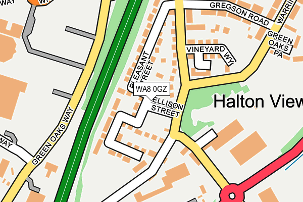
WA8 0GZ is located in the Halton View electoral ward, within the unitary authority of Halton and the English Parliamentary constituency of Halton. The Sub Integrated Care Board (ICB) Location is NHS Cheshire and Merseyside ICB - 01F and the police force is Cheshire. This postcode has been in use since April 2017.


GetTheData
Source: OS OpenMap – Local (Ordnance Survey)
Source: OS VectorMap District (Ordnance Survey)
Licence: Open Government Licence (requires attribution)
| Easting | 352243 |
| Northing | 385874 |
| Latitude | 53.367578 |
| Longitude | -2.719177 |
GetTheData
Source: Open Postcode Geo
Licence: Open Government Licence
| Country | England |
| Postcode District | WA8 |
➜ See where WA8 is on a map ➜ Where is Widnes? | |
GetTheData
Source: Land Registry Price Paid Data
Licence: Open Government Licence
| Ward | Halton View |
| Constituency | Halton |
GetTheData
Source: ONS Postcode Database
Licence: Open Government Licence
| Green Oaks (Town Centre) | Widnes | 225m |
| Green Oaks (Town Centre) | Widnes | 225m |
| Green Oaks | Widnes | 251m |
| Green Oaks Path (Warrington Road) | Widnes | 288m |
| St Ambrose Road (Frank Street) | Widnes | 353m |
| Widnes Station | 1.5km |
| Runcorn Station | 3.5km |
| Hough Green Station | 3.8km |
GetTheData
Source: NaPTAN
Licence: Open Government Licence
| Percentage of properties with Next Generation Access | 100.0% |
| Percentage of properties with Superfast Broadband | 100.0% |
| Percentage of properties with Ultrafast Broadband | 0.0% |
| Percentage of properties with Full Fibre Broadband | 0.0% |
Superfast Broadband is between 30Mbps and 300Mbps
Ultrafast Broadband is > 300Mbps
| Median download speed | 24.6Mbps |
| Average download speed | 23.7Mbps |
| Maximum download speed | 55.00Mbps |
| Median upload speed | 1.6Mbps |
| Average upload speed | 4.3Mbps |
| Maximum upload speed | 10.00Mbps |
| Percentage of properties unable to receive 2Mbps | 0.0% |
| Percentage of properties unable to receive 5Mbps | 0.0% |
| Percentage of properties unable to receive 10Mbps | 0.0% |
| Percentage of properties unable to receive 30Mbps | 0.0% |
GetTheData
Source: Ofcom
Licence: Ofcom Terms of Use (requires attribution)
GetTheData
Source: ONS Postcode Database
Licence: Open Government Licence


➜ Get more ratings from the Food Standards Agency
GetTheData
Source: Food Standards Agency
Licence: FSA terms & conditions
| Last Collection | |||
|---|---|---|---|
| Location | Mon-Fri | Sat | Distance |
| Elliott Street | 17:30 | 11:00 | 615m |
| Greenway Road | 17:30 | 11:00 | 935m |
| Head Office | 18:30 | 12:30 | 938m |
GetTheData
Source: Dracos
Licence: Creative Commons Attribution-ShareAlike
The below table lists the International Territorial Level (ITL) codes (formerly Nomenclature of Territorial Units for Statistics (NUTS) codes) and Local Administrative Units (LAU) codes for WA8 0GZ:
| ITL 1 Code | Name |
|---|---|
| TLD | North West (England) |
| ITL 2 Code | Name |
| TLD7 | Merseyside |
| ITL 3 Code | Name |
| TLD71 | East Merseyside |
| LAU 1 Code | Name |
| E06000006 | Halton |
GetTheData
Source: ONS Postcode Directory
Licence: Open Government Licence
The below table lists the Census Output Area (OA), Lower Layer Super Output Area (LSOA), and Middle Layer Super Output Area (MSOA) for WA8 0GZ:
| Code | Name | |
|---|---|---|
| OA | E00062403 | |
| LSOA | E01012367 | Halton 007A |
| MSOA | E02002580 | Halton 007 |
GetTheData
Source: ONS Postcode Directory
Licence: Open Government Licence
| WA8 0AP | Warrington Road | 179m |
| WA8 0AB | Page Lane | 219m |
| WA8 0BX | Gregson Road | 231m |
| WA8 0AD | Bellhouse Road | 285m |
| WA8 0BA | Warrington Road | 305m |
| WA8 0BU | Green Oaks Path | 322m |
| WA8 0AQ | Frank Street | 337m |
| WA8 0AW | Black Dentons Place | 337m |
| WA8 6LR | Denton Street | 367m |
| WA8 6LP | Bower Street | 367m |
GetTheData
Source: Open Postcode Geo; Land Registry Price Paid Data
Licence: Open Government Licence