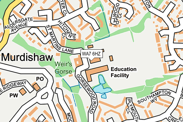
WA7 6HZ is located in the Norton North electoral ward, within the unitary authority of Halton and the English Parliamentary constituency of Weaver Vale. The Sub Integrated Care Board (ICB) Location is NHS Cheshire and Merseyside ICB - 01F and the police force is Cheshire. This postcode has been in use since January 1980.


GetTheData
Source: OS OpenMap – Local (Ordnance Survey)
Source: OS VectorMap District (Ordnance Survey)
Licence: Open Government Licence (requires attribution)
| Easting | 355998 |
| Northing | 381027 |
| Latitude | 53.324324 |
| Longitude | -2.662074 |
GetTheData
Source: Open Postcode Geo
Licence: Open Government Licence
| Country | England |
| Postcode District | WA7 |
➜ See where WA7 is on a map ➜ Where is Runcorn? | |
GetTheData
Source: Land Registry Price Paid Data
Licence: Open Government Licence
Elevation or altitude of WA7 6HZ as distance above sea level:
| Metres | Feet | |
|---|---|---|
| Elevation | 40m | 131ft |
Elevation is measured from the approximate centre of the postcode, to the nearest point on an OS contour line from OS Terrain 50, which has contour spacing of ten vertical metres.
➜ How high above sea level am I? Find the elevation of your current position using your device's GPS.
GetTheData
Source: Open Postcode Elevation
Licence: Open Government Licence
| Ward | Norton North |
| Constituency | Weaver Vale |
GetTheData
Source: ONS Postcode Database
Licence: Open Government Licence
| Murdishaw Cen. (Busway (Murdishaw)) | Murdishaw | 179m |
| Murdishaw Cen. (Busway (Murdishaw)) | Murdishaw | 200m |
| Murdishaw Avenue | Murdishaw | 261m |
| Littlebourne Park (Littlebourne) | Murdishaw | 290m |
| Murdishaw Avenue (Busway (Murdishaw)) | Murdishaw | 314m |
| Runcorn East Station | 0.4km |
| Frodsham Station | 5.2km |
GetTheData
Source: NaPTAN
Licence: Open Government Licence
GetTheData
Source: ONS Postcode Database
Licence: Open Government Licence


➜ Get more ratings from the Food Standards Agency
GetTheData
Source: Food Standards Agency
Licence: FSA terms & conditions
| Last Collection | |||
|---|---|---|---|
| Location | Mon-Fri | Sat | Distance |
| Bristol Avenue | 17:30 | 11:00 | 310m |
| Chichester Close | 17:15 | 11:00 | 515m |
| Preston Brook S.o. | 16:00 | 12:00 | 827m |
GetTheData
Source: Dracos
Licence: Creative Commons Attribution-ShareAlike
The below table lists the International Territorial Level (ITL) codes (formerly Nomenclature of Territorial Units for Statistics (NUTS) codes) and Local Administrative Units (LAU) codes for WA7 6HZ:
| ITL 1 Code | Name |
|---|---|
| TLD | North West (England) |
| ITL 2 Code | Name |
| TLD7 | Merseyside |
| ITL 3 Code | Name |
| TLD71 | East Merseyside |
| LAU 1 Code | Name |
| E06000006 | Halton |
GetTheData
Source: ONS Postcode Directory
Licence: Open Government Licence
The below table lists the Census Output Area (OA), Lower Layer Super Output Area (LSOA), and Middle Layer Super Output Area (MSOA) for WA7 6HZ:
| Code | Name | |
|---|---|---|
| OA | E00062719 | |
| LSOA | E01012433 | Halton 014B |
| MSOA | E02002587 | Halton 014 |
GetTheData
Source: ONS Postcode Directory
Licence: Open Government Licence
| WA7 6HT | Micklegate | 126m |
| WA7 6HY | Hitchens Close | 129m |
| WA7 6JL | Dalwood Close | 168m |
| WA7 6JA | Dover Close | 175m |
| WA7 6HQ | Chiswick Close | 189m |
| WA7 6DA | Mooring Close | 199m |
| WA7 6HU | Baxter Close | 221m |
| WA7 6HL | Moorland Drive | 241m |
| WA7 6JB | Plymouth Close | 245m |
| WA7 6EY | Littlebourne | 252m |
GetTheData
Source: Open Postcode Geo; Land Registry Price Paid Data
Licence: Open Government Licence