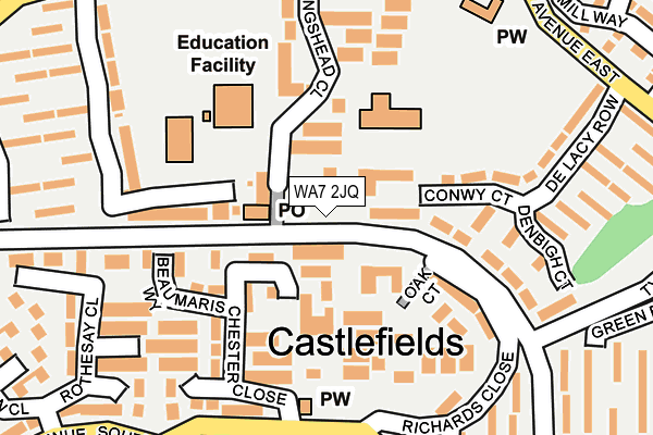
WA7 2JQ lies on Kingshead Close in Castlefields, Runcorn. WA7 2JQ is located in the Halton Castle electoral ward, within the unitary authority of Halton and the English Parliamentary constituency of Halton. The Sub Integrated Care Board (ICB) Location is NHS Cheshire and Merseyside ICB - 01F and the police force is Cheshire. This postcode has been in use since January 1980.


GetTheData
Source: OS OpenMap – Local (Ordnance Survey)
Source: OS VectorMap District (Ordnance Survey)
Licence: Open Government Licence (requires attribution)
| Easting | 354031 |
| Northing | 382649 |
| Latitude | 53.338750 |
| Longitude | -2.691839 |
GetTheData
Source: Open Postcode Geo
Licence: Open Government Licence
| Street | Kingshead Close |
| Locality | Castlefields |
| Town/City | Runcorn |
| Country | England |
| Postcode District | WA7 |
➜ See where WA7 is on a map ➜ Where is Runcorn? | |
GetTheData
Source: Land Registry Price Paid Data
Licence: Open Government Licence
Elevation or altitude of WA7 2JQ as distance above sea level:
| Metres | Feet | |
|---|---|---|
| Elevation | 50m | 164ft |
Elevation is measured from the approximate centre of the postcode, to the nearest point on an OS contour line from OS Terrain 50, which has contour spacing of ten vertical metres.
➜ How high above sea level am I? Find the elevation of your current position using your device's GPS.
GetTheData
Source: Open Postcode Elevation
Licence: Open Government Licence
| Ward | Halton Castle |
| Constituency | Halton |
GetTheData
Source: ONS Postcode Database
Licence: Open Government Licence
| Castlefields Ctr. (Busway (Castlefields)) | Halton Village | 49m |
| Castlefields Ctr. (Busway (Castlefields)) | Halton Village | 56m |
| Castlefields Avenue North | Castlefields | 298m |
| Castlefields Avenue North (Hail And Ride) (Castlefields Avenue North) | Castlefields | 315m |
| The Barge (Castlefields Avenue East) | Castlefields | 320m |
| Runcorn East Station | 2.1km |
| Runcorn Station | 3.2km |
| Widnes Station | 5.2km |
GetTheData
Source: NaPTAN
Licence: Open Government Licence
GetTheData
Source: ONS Postcode Database
Licence: Open Government Licence


➜ Get more ratings from the Food Standards Agency
GetTheData
Source: Food Standards Agency
Licence: FSA terms & conditions
| Last Collection | |||
|---|---|---|---|
| Location | Mon-Fri | Sat | Distance |
| Plantation Close | 17:00 | 11:00 | 392m |
| Astmoor Ind Estate | 18:15 | 12:00 | 642m |
| Halton Brow | 17:30 | 11:30 | 657m |
GetTheData
Source: Dracos
Licence: Creative Commons Attribution-ShareAlike
The below table lists the International Territorial Level (ITL) codes (formerly Nomenclature of Territorial Units for Statistics (NUTS) codes) and Local Administrative Units (LAU) codes for WA7 2JQ:
| ITL 1 Code | Name |
|---|---|
| TLD | North West (England) |
| ITL 2 Code | Name |
| TLD7 | Merseyside |
| ITL 3 Code | Name |
| TLD71 | East Merseyside |
| LAU 1 Code | Name |
| E06000006 | Halton |
GetTheData
Source: ONS Postcode Directory
Licence: Open Government Licence
The below table lists the Census Output Area (OA), Lower Layer Super Output Area (LSOA), and Middle Layer Super Output Area (MSOA) for WA7 2JQ:
| Code | Name | |
|---|---|---|
| OA | E00062470 | |
| LSOA | E01012382 | Halton 010B |
| MSOA | E02002583 | Halton 010 |
GetTheData
Source: ONS Postcode Directory
Licence: Open Government Licence
| WA7 2HY | Chester Close | 116m |
| WA7 2SD | Conwy Court | 139m |
| WA7 2HZ | Rothesay Close | 159m |
| WA7 2JH | Keepers Walk | 165m |
| WA7 2JF | Kingshead Close | 203m |
| WA7 2HR | Richard Close | 204m |
| WA7 2JG | Kingshead Close | 207m |
| WA7 2LG | Shepherds Row | 234m |
| WA7 2NP | Denbigh Court | 253m |
| WA7 2NX | Canalside Cottage | 268m |
GetTheData
Source: Open Postcode Geo; Land Registry Price Paid Data
Licence: Open Government Licence