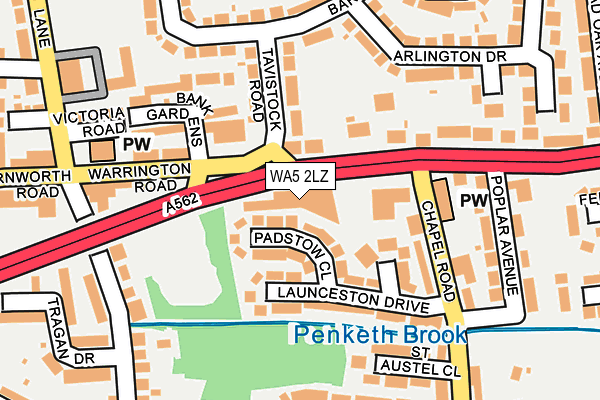
WA5 2LZ is located in the Penketh and Cuerdley electoral ward, within the unitary authority of Warrington and the English Parliamentary constituency of Warrington South. The Sub Integrated Care Board (ICB) Location is NHS Cheshire and Merseyside ICB - 02E and the police force is Cheshire. This postcode has been in use since January 1980.


GetTheData
Source: OS OpenMap – Local (Ordnance Survey)
Source: OS VectorMap District (Ordnance Survey)
Licence: Open Government Licence (requires attribution)
| Easting | 356192 |
| Northing | 387536 |
| Latitude | 53.382843 |
| Longitude | -2.660065 |
GetTheData
Source: Open Postcode Geo
Licence: Open Government Licence
| Country | England |
| Postcode District | WA5 |
➜ See where WA5 is on a map ➜ Where is Warrington? | |
GetTheData
Source: Land Registry Price Paid Data
Licence: Open Government Licence
Elevation or altitude of WA5 2LZ as distance above sea level:
| Metres | Feet | |
|---|---|---|
| Elevation | 10m | 33ft |
Elevation is measured from the approximate centre of the postcode, to the nearest point on an OS contour line from OS Terrain 50, which has contour spacing of ten vertical metres.
➜ How high above sea level am I? Find the elevation of your current position using your device's GPS.
GetTheData
Source: Open Postcode Elevation
Licence: Open Government Licence
| Ward | Penketh And Cuerdley |
| Constituency | Warrington South |
GetTheData
Source: ONS Postcode Database
Licence: Open Government Licence
| Red Lion (Warrington Road) | Penketh | 45m |
| Barnstaple Way (Tavistock Road) | Penketh | 109m |
| Barnstaple Way (Tavistock Road) | Penketh | 114m |
| Bank Gardens (Widnes Road) | Doe Green | 156m |
| Post Office (Warrington Road) | Penketh | 196m |
| Sankey for Penketh Station | 1.2km |
| Warrington Bank Quay Station | 3.9km |
| Warrington Central Station | 4.6km |
GetTheData
Source: NaPTAN
Licence: Open Government Licence
GetTheData
Source: ONS Postcode Database
Licence: Open Government Licence


➜ Get more ratings from the Food Standards Agency
GetTheData
Source: Food Standards Agency
Licence: FSA terms & conditions
| Last Collection | |||
|---|---|---|---|
| Location | Mon-Fri | Sat | Distance |
| Crown & Cushion | 17:15 | 11:00 | 217m |
| Maple Crescent | 16:00 | 11:00 | 265m |
| Great Sankey S.o. | 17:30 | 12:00 | 1,142m |
GetTheData
Source: Dracos
Licence: Creative Commons Attribution-ShareAlike
The below table lists the International Territorial Level (ITL) codes (formerly Nomenclature of Territorial Units for Statistics (NUTS) codes) and Local Administrative Units (LAU) codes for WA5 2LZ:
| ITL 1 Code | Name |
|---|---|
| TLD | North West (England) |
| ITL 2 Code | Name |
| TLD6 | Cheshire |
| ITL 3 Code | Name |
| TLD61 | Warrington |
| LAU 1 Code | Name |
| E06000007 | Warrington |
GetTheData
Source: ONS Postcode Directory
Licence: Open Government Licence
The below table lists the Census Output Area (OA), Lower Layer Super Output Area (LSOA), and Middle Layer Super Output Area (MSOA) for WA5 2LZ:
| Code | Name | |
|---|---|---|
| OA | E00063208 | |
| LSOA | E01012529 | Warrington 019C |
| MSOA | E02002608 | Warrington 019 |
GetTheData
Source: ONS Postcode Directory
Licence: Open Government Licence
| WA5 2NF | Padstow Close | 54m |
| WA5 2NE | Penryn Close | 98m |
| WA5 2ND | Launceston Drive | 111m |
| WA5 2QN | Tavistock Road | 117m |
| WA5 2NA | Chapel Road | 133m |
| WA5 2RU | Bank Gardens | 137m |
| WA5 2EN | Warrington Road | 155m |
| WA5 2RX | Warrington Road | 166m |
| WA5 2NB | Chapel Road | 172m |
| WA5 2QH | Withycombe Road | 195m |
GetTheData
Source: Open Postcode Geo; Land Registry Price Paid Data
Licence: Open Government Licence