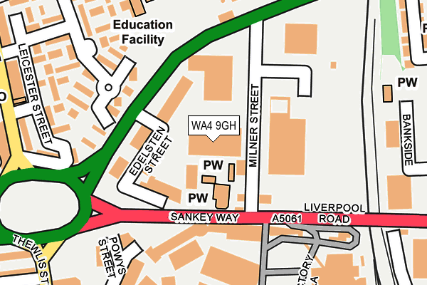
WA4 9GH is located in the Bewsey and Whitecross electoral ward, within the unitary authority of Warrington and the English Parliamentary constituency of Warrington South. The Sub Integrated Care Board (ICB) Location is NHS Cheshire and Merseyside ICB - 02E and the police force is Cheshire. This postcode has been in use since August 2009.


GetTheData
Source: OS OpenMap – Local (Ordnance Survey)
Source: OS VectorMap District (Ordnance Survey)
Licence: Open Government Licence (requires attribution)
| Easting | 359712 |
| Northing | 388260 |
| Latitude | 53.389631 |
| Longitude | -2.607242 |
GetTheData
Source: Open Postcode Geo
Licence: Open Government Licence
| Country | England |
| Postcode District | WA4 |
➜ See where WA4 is on a map ➜ Where is Warrington? | |
GetTheData
Source: Land Registry Price Paid Data
Licence: Open Government Licence
Elevation or altitude of WA4 9GH as distance above sea level:
| Metres | Feet | |
|---|---|---|
| Elevation | 10m | 33ft |
Elevation is measured from the approximate centre of the postcode, to the nearest point on an OS contour line from OS Terrain 50, which has contour spacing of ten vertical metres.
➜ How high above sea level am I? Find the elevation of your current position using your device's GPS.
GetTheData
Source: Open Postcode Elevation
Licence: Open Government Licence
| Ward | Bewsey And Whitecross |
| Constituency | Warrington South |
GetTheData
Source: ONS Postcode Database
Licence: Open Government Licence
| Crosfields (Liverpool Road) | Bank Quay | 119m |
| Crosfields (Liverpool Road) | Bank Quay | 131m |
| Guardian Medical Centre (Priestley Street) | Bank Quay | 169m |
| The Hatter (Lovely Lane) | Bewsey | 278m |
| The Hatter (Lovely Lane) | Bewsey | 330m |
| Warrington Bank Quay Station | 0.5km |
| Warrington Central Station | 1km |
| Sankey for Penketh Station | 2.9km |
GetTheData
Source: NaPTAN
Licence: Open Government Licence
GetTheData
Source: ONS Postcode Database
Licence: Open Government Licence


➜ Get more ratings from the Food Standards Agency
GetTheData
Source: Food Standards Agency
Licence: FSA terms & conditions
| Last Collection | |||
|---|---|---|---|
| Location | Mon-Fri | Sat | Distance |
| Milner Street Business Box | 18:30 | 21m | |
| Milner Street D O | 18:30 | 13:45 | 40m |
| Bank Quay Station | 17:30 | 11:00 | 503m |
GetTheData
Source: Dracos
Licence: Creative Commons Attribution-ShareAlike
The below table lists the International Territorial Level (ITL) codes (formerly Nomenclature of Territorial Units for Statistics (NUTS) codes) and Local Administrative Units (LAU) codes for WA4 9GH:
| ITL 1 Code | Name |
|---|---|
| TLD | North West (England) |
| ITL 2 Code | Name |
| TLD6 | Cheshire |
| ITL 3 Code | Name |
| TLD61 | Warrington |
| LAU 1 Code | Name |
| E06000007 | Warrington |
GetTheData
Source: ONS Postcode Directory
Licence: Open Government Licence
The below table lists the Census Output Area (OA), Lower Layer Super Output Area (LSOA), and Middle Layer Super Output Area (MSOA) for WA4 9GH:
| Code | Name | |
|---|---|---|
| OA | E00062812 | |
| LSOA | E01033302 | Warrington 018G |
| MSOA | E02002607 | Warrington 018 |
GetTheData
Source: ONS Postcode Directory
Licence: Open Government Licence
| WA5 1WA | Milner Street | 0m |
| WA5 1TW | Green Street | 105m |
| WA5 1TA | Leicester Street | 214m |
| WA5 1SZ | Leicester Street | 223m |
| WA5 1TR | Green Street | 231m |
| WA5 1LX | Lovely Lane | 265m |
| WA5 1TB | Leicester Street | 273m |
| WA5 1TG | Collin Street | 282m |
| WA5 1LZ | Lovely Lane | 296m |
| WA5 1NF | Lovely Lane | 311m |
GetTheData
Source: Open Postcode Geo; Land Registry Price Paid Data
Licence: Open Government Licence