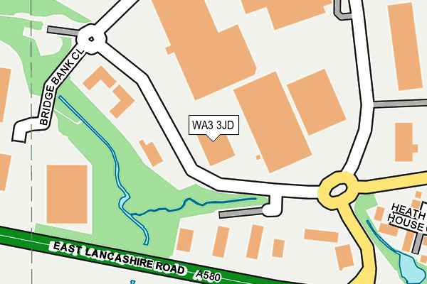
WA3 3JD lies on Yew Tree Way in Golborne, Warrington. WA3 3JD is located in the Golborne & Lowton West electoral ward, within the metropolitan district of Wigan and the English Parliamentary constituency of Leigh. The Sub Integrated Care Board (ICB) Location is NHS Greater Manchester ICB - 02H and the police force is Greater Manchester. This postcode has been in use since December 1998.


GetTheData
Source: OS OpenMap – Local (Ordnance Survey)
Source: OS VectorMap District (Ordnance Survey)
Licence: Open Government Licence (requires attribution)
| Easting | 360862 |
| Northing | 397172 |
| Latitude | 53.469835 |
| Longitude | -2.591061 |
GetTheData
Source: Open Postcode Geo
Licence: Open Government Licence
| Street | Yew Tree Way |
| Locality | Golborne |
| Town/City | Warrington |
| Country | England |
| Postcode District | WA3 |
➜ See where WA3 is on a map ➜ Where is Golborne? | |
GetTheData
Source: Land Registry Price Paid Data
Licence: Open Government Licence
Elevation or altitude of WA3 3JD as distance above sea level:
| Metres | Feet | |
|---|---|---|
| Elevation | 30m | 98ft |
Elevation is measured from the approximate centre of the postcode, to the nearest point on an OS contour line from OS Terrain 50, which has contour spacing of ten vertical metres.
➜ How high above sea level am I? Find the elevation of your current position using your device's GPS.
GetTheData
Source: Open Postcode Elevation
Licence: Open Government Licence
| Ward | Golborne & Lowton West |
| Constituency | Leigh |
GetTheData
Source: ONS Postcode Database
Licence: Open Government Licence
| Nook Ln/Derby Rd (Nook Ln) | Golborne | 448m |
| Nook Ln/Derby Rd (Nook Ln) | Golborne | 457m |
| Bridge St/Queen Anne (Bridge St) | Golborne | 531m |
| Nook Ln/Barrowdale Rd (Nook Ln) | Golborne | 537m |
| Bridge St/Park Rd (Bridge St) | Golborne | 540m |
| Newton-le-Willows Station | 2.4km |
| Earlestown Station | 3.7km |
| Bryn Station | 5km |
GetTheData
Source: NaPTAN
Licence: Open Government Licence
| Median download speed | 35.0Mbps |
| Average download speed | 31.5Mbps |
| Maximum download speed | 47.53Mbps |
| Median upload speed | 5.6Mbps |
| Average upload speed | 5.4Mbps |
| Maximum upload speed | 9.09Mbps |
GetTheData
Source: Ofcom
Licence: Ofcom Terms of Use (requires attribution)
Estimated total energy consumption in WA3 3JD by fuel type, 2015.
| Consumption (kWh) | 142,278 |
|---|---|
| Meter count | 9 |
| Mean (kWh/meter) | 15,809 |
| Median (kWh/meter) | 16,391 |
GetTheData
Source: Postcode level gas estimates: 2015 (experimental)
Source: Postcode level electricity estimates: 2015 (experimental)
Licence: Open Government Licence
GetTheData
Source: ONS Postcode Database
Licence: Open Government Licence


➜ Get more ratings from the Food Standards Agency
GetTheData
Source: Food Standards Agency
Licence: FSA terms & conditions
| Last Collection | |||
|---|---|---|---|
| Location | Mon-Fri | Sat | Distance |
| Kings Road | 16:00 | 11:00 | 566m |
| Derby Road | 16:30 | 11:00 | 739m |
| St.lukes Old S.o. | 17:15 | 12:00 | 832m |
GetTheData
Source: Dracos
Licence: Creative Commons Attribution-ShareAlike
The below table lists the International Territorial Level (ITL) codes (formerly Nomenclature of Territorial Units for Statistics (NUTS) codes) and Local Administrative Units (LAU) codes for WA3 3JD:
| ITL 1 Code | Name |
|---|---|
| TLD | North West (England) |
| ITL 2 Code | Name |
| TLD3 | Greater Manchester |
| ITL 3 Code | Name |
| TLD36 | Greater Manchester North West |
| LAU 1 Code | Name |
| E08000010 | Wigan |
GetTheData
Source: ONS Postcode Directory
Licence: Open Government Licence
The below table lists the Census Output Area (OA), Lower Layer Super Output Area (LSOA), and Middle Layer Super Output Area (MSOA) for WA3 3JD:
| Code | Name | |
|---|---|---|
| OA | E00032136 | |
| LSOA | E01006346 | Wigan 038E |
| MSOA | E02001324 | Wigan 038 |
GetTheData
Source: ONS Postcode Directory
Licence: Open Government Licence
| WA3 3GT | Bridge Bank Close | 137m |
| WA3 2SN | Heath House Close | 300m |
| WA3 2SH | Stone Cross Lane North | 316m |
| WA3 2BU | Heath Field Close | 334m |
| WA3 2SQ | Stone Cross Lane North | 396m |
| WA3 2SG | Stone Cross Lane North | 398m |
| WA3 3JW | Nook Lane | 415m |
| WA3 3JP | Holcombe Avenue | 420m |
| WA3 3WN | Belton Close | 431m |
| WA3 3JS | Queens Drive | 441m |
GetTheData
Source: Open Postcode Geo; Land Registry Price Paid Data
Licence: Open Government Licence