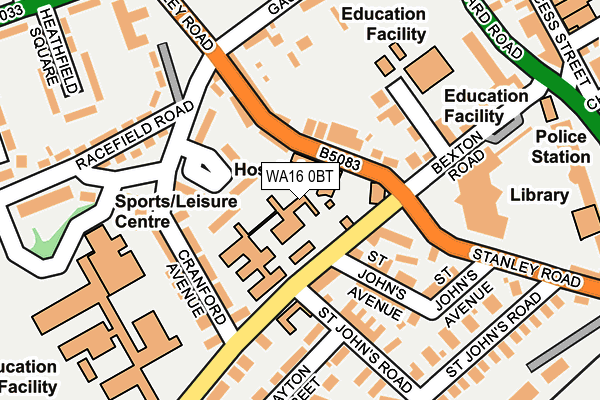
WA16 0BT is located in the Knutsford electoral ward, within the unitary authority of Cheshire East and the English Parliamentary constituency of Tatton. The Sub Integrated Care Board (ICB) Location is NHS Cheshire and Merseyside ICB - 27D and the police force is Cheshire. This postcode has been in use since February 1990.


GetTheData
Source: OS OpenMap – Local (Ordnance Survey)
Source: OS VectorMap District (Ordnance Survey)
Licence: Open Government Licence (requires attribution)
| Easting | 374866 |
| Northing | 378406 |
| Latitude | 53.302017 |
| Longitude | -2.378603 |
GetTheData
Source: Open Postcode Geo
Licence: Open Government Licence
| Country | England |
| Postcode District | WA16 |
➜ See where WA16 is on a map ➜ Where is Knutsford? | |
GetTheData
Source: Land Registry Price Paid Data
Licence: Open Government Licence
Elevation or altitude of WA16 0BT as distance above sea level:
| Metres | Feet | |
|---|---|---|
| Elevation | 60m | 197ft |
Elevation is measured from the approximate centre of the postcode, to the nearest point on an OS contour line from OS Terrain 50, which has contour spacing of ten vertical metres.
➜ How high above sea level am I? Find the elevation of your current position using your device's GPS.
GetTheData
Source: Open Postcode Elevation
Licence: Open Government Licence
| Ward | Knutsford |
| Constituency | Tatton |
GetTheData
Source: ONS Postcode Database
Licence: Open Government Licence
| St John's Avenue (Stanley Road) | Knutsford | 168m |
| Leisure Centre (Cranford Avenue) | Knutsford | 172m |
| Church Hill (King Edward Road) | Knutsford | 324m |
| Heathfield Square (Northwich Road) | Knutsford | 347m |
| Heathfield Square (Northwich Road) | Knutsford | 356m |
| Knutsford Station | 0.5km |
| Plumley Station | 4.1km |
| Mobberley Station | 4.3km |
GetTheData
Source: NaPTAN
Licence: Open Government Licence
GetTheData
Source: ONS Postcode Database
Licence: Open Government Licence


➜ Get more ratings from the Food Standards Agency
GetTheData
Source: Food Standards Agency
Licence: FSA terms & conditions
| Last Collection | |||
|---|---|---|---|
| Location | Mon-Fri | Sat | Distance |
| Bexton Road | 17:30 | 11:00 | 82m |
| Knutsford T.b.o. | 18:30 | 12:00 | 306m |
| Toft Road | 18:30 | 309m | |
GetTheData
Source: Dracos
Licence: Creative Commons Attribution-ShareAlike
The below table lists the International Territorial Level (ITL) codes (formerly Nomenclature of Territorial Units for Statistics (NUTS) codes) and Local Administrative Units (LAU) codes for WA16 0BT:
| ITL 1 Code | Name |
|---|---|
| TLD | North West (England) |
| ITL 2 Code | Name |
| TLD6 | Cheshire |
| ITL 3 Code | Name |
| TLD62 | Cheshire East |
| LAU 1 Code | Name |
| E06000049 | Cheshire East |
GetTheData
Source: ONS Postcode Directory
Licence: Open Government Licence
The below table lists the Census Output Area (OA), Lower Layer Super Output Area (LSOA), and Middle Layer Super Output Area (MSOA) for WA16 0BT:
| Code | Name | |
|---|---|---|
| OA | E00093887 | |
| LSOA | E01018604 | Cheshire East 010B |
| MSOA | E02003863 | Cheshire East 010 |
GetTheData
Source: ONS Postcode Directory
Licence: Open Government Licence
| WA16 0BF | Masters Court | 50m |
| WA16 0EL | Cranford Square | 63m |
| WA16 0DQ | Bexton Road | 81m |
| WA16 0DE | Stanley Road | 90m |
| WA16 0EB | Cranford Avenue | 110m |
| WA16 0DG | County Terrace | 116m |
| WA16 0DH | St Johns Avenue | 130m |
| WA16 0DP | St Johns Road | 145m |
| WA16 0EE | Bexton Road | 165m |
| WA16 0BW | Racefield Road | 168m |
GetTheData
Source: Open Postcode Geo; Land Registry Price Paid Data
Licence: Open Government Licence