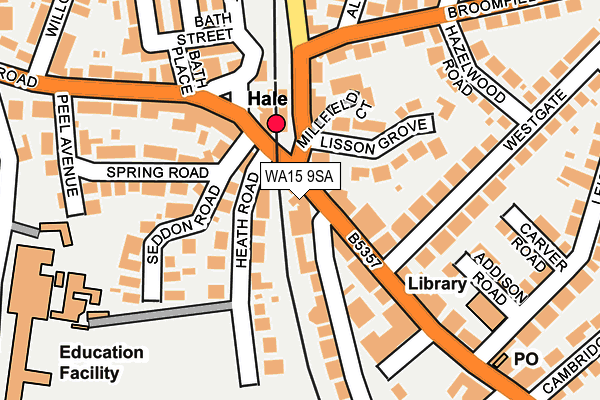
WA15 9SA lies on Ashley Road in Hale, Altrincham. WA15 9SA is located in the Hale electoral ward, within the metropolitan district of Trafford and the English Parliamentary constituency of Altrincham and Sale West. The Sub Integrated Care Board (ICB) Location is NHS Greater Manchester ICB - 02A and the police force is Greater Manchester. This postcode has been in use since January 1980.


GetTheData
Source: OS OpenMap – Local (Ordnance Survey)
Source: OS VectorMap District (Ordnance Survey)
Licence: Open Government Licence (requires attribution)
| Easting | 377006 |
| Northing | 386818 |
| Latitude | 53.377710 |
| Longitude | -2.347108 |
GetTheData
Source: Open Postcode Geo
Licence: Open Government Licence
| Street | Ashley Road |
| Locality | Hale |
| Town/City | Altrincham |
| Country | England |
| Postcode District | WA15 |
➜ See where WA15 is on a map ➜ Where is Hale? | |
GetTheData
Source: Land Registry Price Paid Data
Licence: Open Government Licence
Elevation or altitude of WA15 9SA as distance above sea level:
| Metres | Feet | |
|---|---|---|
| Elevation | 40m | 131ft |
Elevation is measured from the approximate centre of the postcode, to the nearest point on an OS contour line from OS Terrain 50, which has contour spacing of ten vertical metres.
➜ How high above sea level am I? Find the elevation of your current position using your device's GPS.
GetTheData
Source: Open Postcode Elevation
Licence: Open Government Licence
| Ward | Hale |
| Constituency | Altrincham And Sale West |
GetTheData
Source: ONS Postcode Database
Licence: Open Government Licence
| Ashley Rd/Hale Station (Ashley Road) | Hale | 17m |
| Ashley Road/Hale Station (Ashley Road) | Hale | 21m |
| Ashley Road/Hale Village (Ashley Road) | Hale | 182m |
| Ashley Road/Hale Village (Ashley Road) | Hale | 206m |
| Altrincham Grammar School For Boys (Marlborough Rd) | Rosehill | 320m |
| Altrincham (Manchester Metrolink) (Stamford New Road) | Altrincham | 1,142m |
| Hale Station | 0.1km |
| Altrincham Station | 1.1km |
| Navigation Road Station | 2km |
GetTheData
Source: NaPTAN
Licence: Open Government Licence
Estimated total energy consumption in WA15 9SA by fuel type, 2015.
| Consumption (kWh) | 80,334 |
|---|---|
| Meter count | 6 |
| Mean (kWh/meter) | 13,389 |
| Median (kWh/meter) | 14,485 |
GetTheData
Source: Postcode level gas estimates: 2015 (experimental)
Source: Postcode level electricity estimates: 2015 (experimental)
Licence: Open Government Licence
GetTheData
Source: ONS Postcode Database
Licence: Open Government Licence


➜ Get more ratings from the Food Standards Agency
GetTheData
Source: Food Standards Agency
Licence: FSA terms & conditions
| Last Collection | |||
|---|---|---|---|
| Location | Mon-Fri | Sat | Distance |
| Hale Station | 18:30 | 11:00 | 84m |
| Hale Station | 18:30 | 113m | |
| Broomfield Lane | 17:30 | 11:00 | 175m |
GetTheData
Source: Dracos
Licence: Creative Commons Attribution-ShareAlike
The below table lists the International Territorial Level (ITL) codes (formerly Nomenclature of Territorial Units for Statistics (NUTS) codes) and Local Administrative Units (LAU) codes for WA15 9SA:
| ITL 1 Code | Name |
|---|---|
| TLD | North West (England) |
| ITL 2 Code | Name |
| TLD3 | Greater Manchester |
| ITL 3 Code | Name |
| TLD34 | Greater Manchester South West |
| LAU 1 Code | Name |
| E08000009 | Trafford |
GetTheData
Source: ONS Postcode Directory
Licence: Open Government Licence
The below table lists the Census Output Area (OA), Lower Layer Super Output Area (LSOA), and Middle Layer Super Output Area (MSOA) for WA15 9SA:
| Code | Name | |
|---|---|---|
| OA | E00030826 | |
| LSOA | E01006082 | Trafford 027C |
| MSOA | E02001285 | Trafford 027 |
GetTheData
Source: ONS Postcode Directory
Licence: Open Government Licence
| WA15 9AF | Victoria Road | 41m |
| WA14 2XQ | Heath Road | 42m |
| WA15 9SD | Ashley Road | 50m |
| WA15 9PA | Cecil Road | 64m |
| WA15 9SF | Ashley Road | 103m |
| WA15 9AE | Lisson Grove | 110m |
| WA14 2UJ | Heath Road | 114m |
| WA15 9BF | Millfield Court | 118m |
| WA15 9AD | Victoria Road | 121m |
| WA14 2UH | Seddon Road | 144m |
GetTheData
Source: Open Postcode Geo; Land Registry Price Paid Data
Licence: Open Government Licence