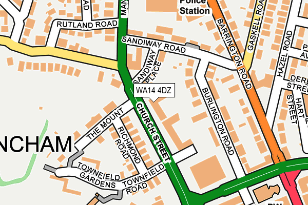
WA14 4DZ is located in the Altrincham electoral ward, within the metropolitan district of Trafford and the English Parliamentary constituency of Altrincham and Sale West. The Sub Integrated Care Board (ICB) Location is NHS Greater Manchester ICB - 02A and the police force is Greater Manchester. This postcode has been in use since January 1980.


GetTheData
Source: OS OpenMap – Local (Ordnance Survey)
Source: OS VectorMap District (Ordnance Survey)
Licence: Open Government Licence (requires attribution)
| Easting | 376766 |
| Northing | 388365 |
| Latitude | 53.391621 |
| Longitude | -2.350829 |
GetTheData
Source: Open Postcode Geo
Licence: Open Government Licence
| Country | England |
| Postcode District | WA14 |
➜ See where WA14 is on a map ➜ Where is Altrincham? | |
GetTheData
Source: Land Registry Price Paid Data
Licence: Open Government Licence
Elevation or altitude of WA14 4DZ as distance above sea level:
| Metres | Feet | |
|---|---|---|
| Elevation | 40m | 131ft |
Elevation is measured from the approximate centre of the postcode, to the nearest point on an OS contour line from OS Terrain 50, which has contour spacing of ten vertical metres.
➜ How high above sea level am I? Find the elevation of your current position using your device's GPS.
GetTheData
Source: Open Postcode Elevation
Licence: Open Government Licence
| Ward | Altrincham |
| Constituency | Altrincham And Sale West |
GetTheData
Source: ONS Postcode Database
Licence: Open Government Licence
| Church Street/The Wheatsheaf (Church Street) | Altrincham | 129m |
| Woodlands Road/Cresta Court Hotel (Woodlands Road) | Altrincham | 139m |
| Woodlands Road/Cresta Court Hotel (Woodlands Road) | Altrincham | 153m |
| Barrington Road/Hazel Road (Barrington Road) | Altrincham | 170m |
| Barrington Road/Hazel Road (Barrington Road) | Altrincham | 179m |
| Altrincham (Manchester Metrolink) (Stamford New Road) | Altrincham | 479m |
| Navigation Road (Manchester Metrolink) (Navigation Road) | Navigation Road | 640m |
| Timperley (Manchester Metrolink) (Park Road) | Timperley | 1,595m |
| Altrincham Station | 0.5km |
| Navigation Road Station | 0.6km |
| Hale Station | 1.5km |
GetTheData
Source: NaPTAN
Licence: Open Government Licence
GetTheData
Source: ONS Postcode Database
Licence: Open Government Licence


➜ Get more ratings from the Food Standards Agency
GetTheData
Source: Food Standards Agency
Licence: FSA terms & conditions
| Last Collection | |||
|---|---|---|---|
| Location | Mon-Fri | Sat | Distance |
| Sandiwayplace | 16:00 | 11:00 | 120m |
| Gaskell Road | 17:30 | 11:00 | 218m |
| Springfield Road | 17:30 | 11:00 | 307m |
GetTheData
Source: Dracos
Licence: Creative Commons Attribution-ShareAlike
The below table lists the International Territorial Level (ITL) codes (formerly Nomenclature of Territorial Units for Statistics (NUTS) codes) and Local Administrative Units (LAU) codes for WA14 4DZ:
| ITL 1 Code | Name |
|---|---|
| TLD | North West (England) |
| ITL 2 Code | Name |
| TLD3 | Greater Manchester |
| ITL 3 Code | Name |
| TLD34 | Greater Manchester South West |
| LAU 1 Code | Name |
| E08000009 | Trafford |
GetTheData
Source: ONS Postcode Directory
Licence: Open Government Licence
The below table lists the Census Output Area (OA), Lower Layer Super Output Area (LSOA), and Middle Layer Super Output Area (MSOA) for WA14 4DZ:
| Code | Name | |
|---|---|---|
| OA | E00030808 | |
| LSOA | E01006075 | Trafford 025B |
| MSOA | E02001283 | Trafford 025 |
GetTheData
Source: ONS Postcode Directory
Licence: Open Government Licence
| WA14 4DU | Richmond Road | 73m |
| WA14 1JT | Burlington Road | 76m |
| WA14 1HR | Burlington Road | 112m |
| WA14 1HT | Sandiway Place | 126m |
| WA14 4DS | Townfield Road | 137m |
| WA14 1HS | Sandiway Road | 151m |
| WA14 1HP | Barrington Road | 153m |
| WA14 4DX | The Mount | 163m |
| WA14 4TT | Church Walk | 171m |
| WA14 1HX | Sandiway Road | 183m |
GetTheData
Source: Open Postcode Geo; Land Registry Price Paid Data
Licence: Open Government Licence