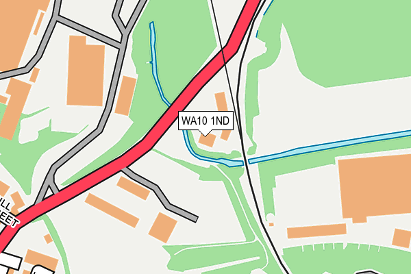
WA10 1ND is located in the Moss Bank electoral ward, within the metropolitan district of St. Helens and the English Parliamentary constituency of St Helens North. The Sub Integrated Care Board (ICB) Location is NHS Cheshire and Merseyside ICB - 01X and the police force is Merseyside. This postcode has been in use since January 1980.


GetTheData
Source: OS OpenMap – Local (Ordnance Survey)
Source: OS VectorMap District (Ordnance Survey)
Licence: Open Government Licence (requires attribution)
| Easting | 351575 |
| Northing | 396262 |
| Latitude | 53.460883 |
| Longitude | -2.730813 |
GetTheData
Source: Open Postcode Geo
Licence: Open Government Licence
| Country | England |
| Postcode District | WA10 |
➜ See where WA10 is on a map ➜ Where is St Helens? | |
GetTheData
Source: Land Registry Price Paid Data
Licence: Open Government Licence
Elevation or altitude of WA10 1ND as distance above sea level:
| Metres | Feet | |
|---|---|---|
| Elevation | 30m | 98ft |
Elevation is measured from the approximate centre of the postcode, to the nearest point on an OS contour line from OS Terrain 50, which has contour spacing of ten vertical metres.
➜ How high above sea level am I? Find the elevation of your current position using your device's GPS.
GetTheData
Source: Open Postcode Elevation
Licence: Open Government Licence
| Ward | Moss Bank |
| Constituency | St Helens North |
GetTheData
Source: ONS Postcode Database
Licence: Open Government Licence
| Hill Street (College Street) | Gerards Bridge | 293m |
| Swift Street (College Street) | St Helens | 359m |
| Ewart Road (Haresfinch Road) | Haresfinch | 389m |
| Birchley Street (Standish Street) | St Helens | 404m |
| Alfred Street (Standish Street) | St Helens | 432m |
| St Helens Central Station | 0.9km |
| Thatto Heath Station | 3.3km |
| St Helens Junction Station | 3.6km |
GetTheData
Source: NaPTAN
Licence: Open Government Licence
GetTheData
Source: ONS Postcode Database
Licence: Open Government Licence


➜ Get more ratings from the Food Standards Agency
GetTheData
Source: Food Standards Agency
Licence: FSA terms & conditions
| Last Collection | |||
|---|---|---|---|
| Location | Mon-Fri | Sat | Distance |
| College Street Post Office | 18:15 | 12:00 | 514m |
| College Street So | 18:15 | 526m | |
| North Road | 17:30 | 11:00 | 632m |
GetTheData
Source: Dracos
Licence: Creative Commons Attribution-ShareAlike
The below table lists the International Territorial Level (ITL) codes (formerly Nomenclature of Territorial Units for Statistics (NUTS) codes) and Local Administrative Units (LAU) codes for WA10 1ND:
| ITL 1 Code | Name |
|---|---|
| TLD | North West (England) |
| ITL 2 Code | Name |
| TLD7 | Merseyside |
| ITL 3 Code | Name |
| TLD71 | East Merseyside |
| LAU 1 Code | Name |
| E08000013 | St. Helens |
GetTheData
Source: ONS Postcode Directory
Licence: Open Government Licence
The below table lists the Census Output Area (OA), Lower Layer Super Output Area (LSOA), and Middle Layer Super Output Area (MSOA) for WA10 1ND:
| Code | Name | |
|---|---|---|
| OA | E00034742 | |
| LSOA | E01006854 | St. Helens 004F |
| MSOA | E02001409 | St. Helens 004 |
GetTheData
Source: ONS Postcode Directory
Licence: Open Government Licence
| WA10 1LS | Strickland Street | 287m |
| WA10 1HX | Brynn Street | 337m |
| WA10 1JU | Hardshaw Street | 337m |
| WA10 2SS | Hill Street | 338m |
| WA11 9NS | Haresfinch Road | 349m |
| WA10 1LA | Vincent Street | 358m |
| WA10 1UA | Gleave Street | 359m |
| WA10 1LR | Alfred Street | 365m |
| WA10 2SR | Cowley Street | 367m |
| WA10 1LP | Charles Street | 376m |
GetTheData
Source: Open Postcode Geo; Land Registry Price Paid Data
Licence: Open Government Licence