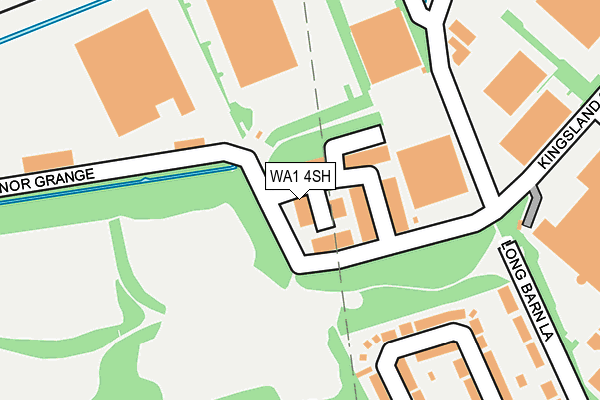
WA1 4SH is located in the Rixton and Woolston electoral ward, within the unitary authority of Warrington and the English Parliamentary constituency of Warrington North. The Sub Integrated Care Board (ICB) Location is NHS Cheshire and Merseyside ICB - 02E and the police force is Cheshire. This postcode has been in use since March 1982.


GetTheData
Source: OS OpenMap – Local (Ordnance Survey)
Source: OS VectorMap District (Ordnance Survey)
Licence: Open Government Licence (requires attribution)
| Easting | 364350 |
| Northing | 390140 |
| Latitude | 53.406880 |
| Longitude | -2.537721 |
GetTheData
Source: Open Postcode Geo
Licence: Open Government Licence
| Country | England |
| Postcode District | WA1 |
➜ See where WA1 is on a map ➜ Where is Warrington? | |
GetTheData
Source: Land Registry Price Paid Data
Licence: Open Government Licence
Elevation or altitude of WA1 4SH as distance above sea level:
| Metres | Feet | |
|---|---|---|
| Elevation | 10m | 33ft |
Elevation is measured from the approximate centre of the postcode, to the nearest point on an OS contour line from OS Terrain 50, which has contour spacing of ten vertical metres.
➜ How high above sea level am I? Find the elevation of your current position using your device's GPS.
GetTheData
Source: Open Postcode Elevation
Licence: Open Government Licence
| Ward | Rixton And Woolston |
| Constituency | Warrington North |
GetTheData
Source: ONS Postcode Database
Licence: Open Government Licence
| Epping Drive (Poulton Crescent) | Woolston | 402m |
| Blackburne Close (Harpers Road) | Longbarn | 497m |
| Blackburne Close (Harpers Road) | Longbarn | 524m |
| Olympic Park (Olympic Way) | Warrington | 541m |
| Olympic Park (Olympic Way) | Warrington | 564m |
| Birchwood Station | 1.1km |
| Padgate Station | 1.3km |
| Warrington Central Station | 4km |
GetTheData
Source: NaPTAN
Licence: Open Government Licence
| Median download speed | 40.0Mbps |
| Average download speed | 42.3Mbps |
| Maximum download speed | 80.00Mbps |
| Median upload speed | 10.0Mbps |
| Average upload speed | 10.3Mbps |
| Maximum upload speed | 20.00Mbps |
GetTheData
Source: Ofcom
Licence: Ofcom Terms of Use (requires attribution)
Estimated total energy consumption in WA1 4SH by fuel type, 2015.
| Consumption (kWh) | 7,146 |
|---|---|
| Meter count | 7 |
| Mean (kWh/meter) | 1,021 |
| Median (kWh/meter) | 163 |
GetTheData
Source: Postcode level gas estimates: 2015 (experimental)
Source: Postcode level electricity estimates: 2015 (experimental)
Licence: Open Government Licence
GetTheData
Source: ONS Postcode Database
Licence: Open Government Licence


➜ Get more ratings from the Food Standards Agency
GetTheData
Source: Food Standards Agency
Licence: FSA terms & conditions
| Last Collection | |||
|---|---|---|---|
| Location | Mon-Fri | Sat | Distance |
| Kingland Grange | 18:30 | 236m | |
| Harpers Road | 16:00 | 11:00 | 501m |
| Gig Lane | 17:30 | 11:00 | 710m |
GetTheData
Source: Dracos
Licence: Creative Commons Attribution-ShareAlike
The below table lists the International Territorial Level (ITL) codes (formerly Nomenclature of Territorial Units for Statistics (NUTS) codes) and Local Administrative Units (LAU) codes for WA1 4SH:
| ITL 1 Code | Name |
|---|---|
| TLD | North West (England) |
| ITL 2 Code | Name |
| TLD6 | Cheshire |
| ITL 3 Code | Name |
| TLD61 | Warrington |
| LAU 1 Code | Name |
| E06000007 | Warrington |
GetTheData
Source: ONS Postcode Directory
Licence: Open Government Licence
The below table lists the Census Output Area (OA), Lower Layer Super Output Area (LSOA), and Middle Layer Super Output Area (MSOA) for WA1 4SH:
| Code | Name | |
|---|---|---|
| OA | E00063327 | |
| LSOA | E01012555 | Warrington 014D |
| MSOA | E02002603 | Warrington 014 |
GetTheData
Source: ONS Postcode Directory
Licence: Open Government Licence
| WA1 4QW | Poulton Crescent | 262m |
| WA1 4QP | Poulton Crescent | 286m |
| WA1 4QR | Longbarn Lane | 298m |
| WA1 4RR | Tatton Court | 311m |
| WA1 4RW | Kingsland Grange | 314m |
| WA2 0UE | Freshfields Drive | 381m |
| WA2 0UG | Sage Close | 382m |
| WA2 0UH | Burnet Close | 436m |
| WA1 4QL | Epping Drive | 454m |
| WA2 0UQ | Lovage Close | 458m |
GetTheData
Source: Open Postcode Geo; Land Registry Price Paid Data
Licence: Open Government Licence