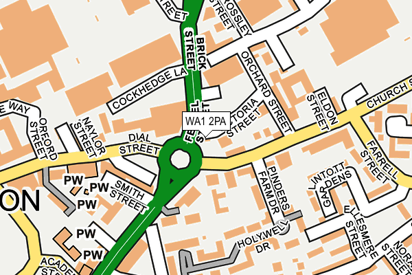
WA1 2PA lies on Fennel Street in Warrington. WA1 2PA is located in the Fairfield and Howley electoral ward, within the unitary authority of Warrington and the English Parliamentary constituency of Warrington North. The Sub Integrated Care Board (ICB) Location is NHS Cheshire and Merseyside ICB - 02E and the police force is Cheshire. This postcode has been in use since January 1980.


GetTheData
Source: OS OpenMap – Local (Ordnance Survey)
Source: OS VectorMap District (Ordnance Survey)
Licence: Open Government Licence (requires attribution)
| Easting | 361114 |
| Northing | 388307 |
| Latitude | 53.390159 |
| Longitude | -2.586168 |
GetTheData
Source: Open Postcode Geo
Licence: Open Government Licence
| Street | Fennel Street |
| Town/City | Warrington |
| Country | England |
| Postcode District | WA1 |
➜ See where WA1 is on a map ➜ Where is Warrington? | |
GetTheData
Source: Land Registry Price Paid Data
Licence: Open Government Licence
Elevation or altitude of WA1 2PA as distance above sea level:
| Metres | Feet | |
|---|---|---|
| Elevation | 10m | 33ft |
Elevation is measured from the approximate centre of the postcode, to the nearest point on an OS contour line from OS Terrain 50, which has contour spacing of ten vertical metres.
➜ How high above sea level am I? Find the elevation of your current position using your device's GPS.
GetTheData
Source: Open Postcode Elevation
Licence: Open Government Licence
| Ward | Fairfield And Howley |
| Constituency | Warrington North |
GetTheData
Source: ONS Postcode Database
Licence: Open Government Licence
| Orchard Street (Church Street) | Howley | 66m |
| Orchard Street (Church Street) | Howley | 72m |
| Cockhedge Lane (Fennel Street) | Howley | 91m |
| Cockhedge Lane (Fennel Street) | Howley | 124m |
| Sainsburys (Church Street) | Howley | 308m |
| Warrington Central Station | 0.5km |
| Warrington Bank Quay Station | 1.2km |
| Padgate Station | 2.6km |
GetTheData
Source: NaPTAN
Licence: Open Government Licence
GetTheData
Source: ONS Postcode Database
Licence: Open Government Licence


➜ Get more ratings from the Food Standards Agency
GetTheData
Source: Food Standards Agency
Licence: FSA terms & conditions
| Last Collection | |||
|---|---|---|---|
| Location | Mon-Fri | Sat | Distance |
| Church Street | 16:45 | 11:00 | 66m |
| Parr Street | 16:45 | 11:00 | 362m |
| Howley Lane | 16:45 | 11:00 | 392m |
GetTheData
Source: Dracos
Licence: Creative Commons Attribution-ShareAlike
| Risk of WA1 2PA flooding from rivers and sea | Low |
| ➜ WA1 2PA flood map | |
GetTheData
Source: Open Flood Risk by Postcode
Licence: Open Government Licence
The below table lists the International Territorial Level (ITL) codes (formerly Nomenclature of Territorial Units for Statistics (NUTS) codes) and Local Administrative Units (LAU) codes for WA1 2PA:
| ITL 1 Code | Name |
|---|---|
| TLD | North West (England) |
| ITL 2 Code | Name |
| TLD6 | Cheshire |
| ITL 3 Code | Name |
| TLD61 | Warrington |
| LAU 1 Code | Name |
| E06000007 | Warrington |
GetTheData
Source: ONS Postcode Directory
Licence: Open Government Licence
The below table lists the Census Output Area (OA), Lower Layer Super Output Area (LSOA), and Middle Layer Super Output Area (MSOA) for WA1 2PA:
| Code | Name | |
|---|---|---|
| OA | E00173157 | |
| LSOA | E01012480 | Warrington 017B |
| MSOA | E02002606 | Warrington 017 |
GetTheData
Source: ONS Postcode Directory
Licence: Open Government Licence
| WA1 2TD | Victoria Street | 52m |
| WA1 2TE | Orchard Street | 74m |
| WA1 2SY | Church Street | 89m |
| WA1 2BE | Dutton Court | 90m |
| WA1 2GF | Pinders Farm Drive | 100m |
| WA1 2NX | Dial Street | 110m |
| WA1 2SZ | Church Street | 121m |
| WA1 2NZ | Buttermarket Street | 127m |
| WA1 2GG | Holywell Drive | 153m |
| WA1 2GE | Holywell Drive | 174m |
GetTheData
Source: Open Postcode Geo; Land Registry Price Paid Data
Licence: Open Government Licence