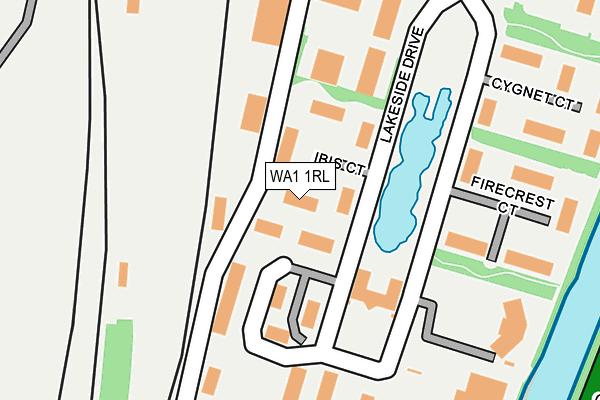
WA1 1RL lies on Ibis Court in Warrington. WA1 1RL is located in the Bewsey and Whitecross electoral ward, within the unitary authority of Warrington and the English Parliamentary constituency of Warrington South. The Sub Integrated Care Board (ICB) Location is NHS Cheshire and Merseyside ICB - 02E and the police force is Cheshire. This postcode has been in use since December 2000.


GetTheData
Source: OS OpenMap – Local (Ordnance Survey)
Source: OS VectorMap District (Ordnance Survey)
Licence: Open Government Licence (requires attribution)
| Easting | 360273 |
| Northing | 387274 |
| Latitude | 53.380828 |
| Longitude | -2.598682 |
GetTheData
Source: Open Postcode Geo
Licence: Open Government Licence
| Street | Ibis Court |
| Town/City | Warrington |
| Country | England |
| Postcode District | WA1 |
➜ See where WA1 is on a map ➜ Where is Warrington? | |
GetTheData
Source: Land Registry Price Paid Data
Licence: Open Government Licence
Elevation or altitude of WA1 1RL as distance above sea level:
| Metres | Feet | |
|---|---|---|
| Elevation | 10m | 33ft |
Elevation is measured from the approximate centre of the postcode, to the nearest point on an OS contour line from OS Terrain 50, which has contour spacing of ten vertical metres.
➜ How high above sea level am I? Find the elevation of your current position using your device's GPS.
GetTheData
Source: Open Postcode Elevation
Licence: Open Government Licence
| Ward | Bewsey And Whitecross |
| Constituency | Warrington South |
GetTheData
Source: ONS Postcode Database
Licence: Open Government Licence
| Ibis Court (Lakeside Drive) | Centre Park | 20m |
| Firecrest Court (Lakeside Drive) | Centre Park | 100m |
| Arpley Meadows (Lakeside Drive) | Centre Park | 160m |
| Bank (Lakeside Drive) | Centre Park | 179m |
| Cygnet Court (Lakeside Drive) | Centre Park | 199m |
| Warrington Bank Quay Station | 0.6km |
| Warrington Central Station | 1.3km |
| Sankey for Penketh Station | 3.7km |
GetTheData
Source: NaPTAN
Licence: Open Government Licence
Estimated total energy consumption in WA1 1RL by fuel type, 2015.
| Consumption (kWh) | 163,119 |
|---|---|
| Meter count | 7 |
| Mean (kWh/meter) | 23,303 |
| Median (kWh/meter) | 20,226 |
GetTheData
Source: Postcode level gas estimates: 2015 (experimental)
Source: Postcode level electricity estimates: 2015 (experimental)
Licence: Open Government Licence
GetTheData
Source: ONS Postcode Database
Licence: Open Government Licence


➜ Get more ratings from the Food Standards Agency
GetTheData
Source: Food Standards Agency
Licence: FSA terms & conditions
| Last Collection | |||
|---|---|---|---|
| Location | Mon-Fri | Sat | Distance |
| Adamson Street | 17:00 | 11:00 | 352m |
| Centre Park | 17:30 | 11:00 | 370m |
| Irwell Road S.o. | 17:30 | 12:00 | 521m |
GetTheData
Source: Dracos
Licence: Creative Commons Attribution-ShareAlike
The below table lists the International Territorial Level (ITL) codes (formerly Nomenclature of Territorial Units for Statistics (NUTS) codes) and Local Administrative Units (LAU) codes for WA1 1RL:
| ITL 1 Code | Name |
|---|---|
| TLD | North West (England) |
| ITL 2 Code | Name |
| TLD6 | Cheshire |
| ITL 3 Code | Name |
| TLD61 | Warrington |
| LAU 1 Code | Name |
| E06000007 | Warrington |
GetTheData
Source: ONS Postcode Directory
Licence: Open Government Licence
The below table lists the Census Output Area (OA), Lower Layer Super Output Area (LSOA), and Middle Layer Super Output Area (MSOA) for WA1 1RL:
| Code | Name | |
|---|---|---|
| OA | E00173146 | |
| LSOA | E01033300 | Warrington 018F |
| MSOA | E02002607 | Warrington 018 |
GetTheData
Source: ONS Postcode Directory
Licence: Open Government Licence
| WA1 1GG | Mandarin Court | 117m |
| WA1 1QL | Slutchers Lane | 127m |
| WA1 1RG | Firecrest Court | 193m |
| WA1 1RX | Lakeside Drive | 210m |
| WA1 1PP | Cygnet Court | 210m |
| WA4 6AQ | Chester Road | 317m |
| WA4 6AG | Wallis Street | 321m |
| WA4 6AH | Sulby Avenue | 363m |
| WA4 6AD | Chester Road | 367m |
| WA4 6AP | Greeba Avenue | 370m |
GetTheData
Source: Open Postcode Geo; Land Registry Price Paid Data
Licence: Open Government Licence