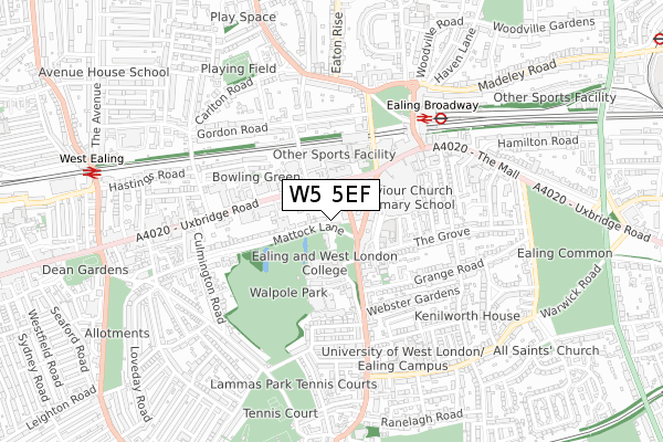
W5 5EF is located in the Ealing Broadway electoral ward, within the London borough of Ealing and the English Parliamentary constituency of Ealing Central and Acton. The Sub Integrated Care Board (ICB) Location is NHS North West London ICB - W2U3Z and the police force is Metropolitan Police. This postcode has been in use since January 2020.


GetTheData
Source: OS Open Zoomstack (Ordnance Survey)
Licence: Open Government Licence (requires attribution)
Attribution: Contains OS data © Crown copyright and database right 2025
Source: Open Postcode Geo
Licence: Open Government Licence (requires attribution)
Attribution: Contains OS data © Crown copyright and database right 2025; Contains Royal Mail data © Royal Mail copyright and database right 2025; Source: Office for National Statistics licensed under the Open Government Licence v.3.0
| Easting | 517591 |
| Northing | 180547 |
| Latitude | 51.511623 |
| Longitude | -0.306850 |
GetTheData
Source: Open Postcode Geo
Licence: Open Government Licence
| Country | England |
| Postcode District | W5 |
➜ See where W5 is on a map ➜ Where is Ealing? | |
GetTheData
Source: Land Registry Price Paid Data
Licence: Open Government Licence
| Ward | Ealing Broadway |
| Constituency | Ealing Central And Acton |
GetTheData
Source: ONS Postcode Database
Licence: Open Government Licence
| Bond Street | Ealing | 88m |
| Ealing Town Hall (Uxbridge Road) | Ealing | 133m |
| Bond Street | Ealing | 156m |
| Longfield Avenue Ealing | Ealing | 176m |
| Christchurch (W5) (New Broadway) | Ealing | 180m |
| Ealing Broadway Underground Station | Ealing Broadway | 533m |
| South Ealing Underground Station | South Ealing | 1,182m |
| Ealing Common Underground Station | Ealing Common | 1,302m |
| North Ealing Underground Station | North Ealing | 1,410m |
| Northfields Underground Station | Northfields | 1,473m |
| Ealing Broadway Station | 0.5km |
| West Ealing Station | 0.9km |
| Drayton Green Station | 1.7km |
GetTheData
Source: NaPTAN
Licence: Open Government Licence
GetTheData
Source: ONS Postcode Database
Licence: Open Government Licence


➜ Get more ratings from the Food Standards Agency
GetTheData
Source: Food Standards Agency
Licence: FSA terms & conditions
| Last Collection | |||
|---|---|---|---|
| Location | Mon-Fri | Sat | Distance |
| The Grove | 17:30 | 12:00 | 164m |
| Questor's Theatre | 17:30 | 12:00 | 176m |
| Ealing Delivery Office | 18:30 | 12:00 | 185m |
GetTheData
Source: Dracos
Licence: Creative Commons Attribution-ShareAlike
The below table lists the International Territorial Level (ITL) codes (formerly Nomenclature of Territorial Units for Statistics (NUTS) codes) and Local Administrative Units (LAU) codes for W5 5EF:
| ITL 1 Code | Name |
|---|---|
| TLI | London |
| ITL 2 Code | Name |
| TLI7 | Outer London - West and North West |
| ITL 3 Code | Name |
| TLI73 | Ealing |
| LAU 1 Code | Name |
| E09000009 | Ealing |
GetTheData
Source: ONS Postcode Directory
Licence: Open Government Licence
The below table lists the Census Output Area (OA), Lower Layer Super Output Area (LSOA), and Middle Layer Super Output Area (MSOA) for W5 5EF:
| Code | Name | |
|---|---|---|
| OA | E00006126 | |
| LSOA | E01001221 | Ealing 020A |
| MSOA | E02000257 | Ealing 020 |
GetTheData
Source: ONS Postcode Directory
Licence: Open Government Licence
| W5 5AS | Bond Street | 90m |
| W5 5AA | Bond Street | 91m |
| W5 5AH | New Broadway | 107m |
| W5 5AP | Bond Street | 117m |
| W5 5AL | New Broadway | 128m |
| W5 5DA | The Green | 136m |
| W5 5BG | Mattock Lane | 147m |
| W5 5AW | New Broadway | 166m |
| W5 5DB | High Street | 177m |
| W5 5BL | The Grove | 181m |
GetTheData
Source: Open Postcode Geo; Land Registry Price Paid Data
Licence: Open Government Licence