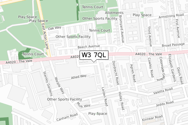
W3 7QL is located in the Southfield electoral ward, within the London borough of Ealing and the English Parliamentary constituency of Ealing Central and Acton. The Sub Integrated Care Board (ICB) Location is NHS North West London ICB - W2U3Z and the police force is Metropolitan Police. This postcode has been in use since June 2019.


GetTheData
Source: OS Open Zoomstack (Ordnance Survey)
Licence: Open Government Licence (requires attribution)
Attribution: Contains OS data © Crown copyright and database right 2025
Source: Open Postcode Geo
Licence: Open Government Licence (requires attribution)
Attribution: Contains OS data © Crown copyright and database right 2025; Contains Royal Mail data © Royal Mail copyright and database right 2025; Source: Office for National Statistics licensed under the Open Government Licence v.3.0
| Easting | 521311 |
| Northing | 180045 |
| Latitude | 51.506326 |
| Longitude | -0.253442 |
GetTheData
Source: Open Postcode Geo
Licence: Open Government Licence
| Country | England |
| Postcode District | W3 |
➜ See where W3 is on a map ➜ Where is Acton? | |
GetTheData
Source: Land Registry Price Paid Data
Licence: Open Government Licence
| Ward | Southfield |
| Constituency | Ealing Central And Acton |
GetTheData
Source: ONS Postcode Database
Licence: Open Government Licence
| Larden Road (The Vale) | East Acton | 52m |
| Larden Road (The Vale) | East Acton | 78m |
| Bromyard Avenue | East Acton | 90m |
| Bromyard Avenue | East Acton | 147m |
| East Acton Lane (The Vale) | East Acton | 183m |
| East Acton Underground Station | East Acton | 1,223m |
| Turnham Green Underground Station | Turnham Green | 1,246m |
| Stamford Brook Underground Station | Stamford Brook | 1,379m |
| Chiswick Park Underground Station | Chiswick Park | 1,646m |
| Ravenscourt Park Underground Station | Ravenscourt Park | 1,826m |
| Acton Central Station | 0.7km |
| South Acton Station | 1.4km |
| Acton Main Line Station | 1.5km |
GetTheData
Source: NaPTAN
Licence: Open Government Licence
GetTheData
Source: ONS Postcode Database
Licence: Open Government Licence


➜ Get more ratings from the Food Standards Agency
GetTheData
Source: Food Standards Agency
Licence: FSA terms & conditions
| Last Collection | |||
|---|---|---|---|
| Location | Mon-Fri | Sat | Distance |
| Post Office | 17:30 | 12:00 | 36m |
| Bromyard Avenue | 17:30 | 12:00 | 198m |
| Stanley Gardens | 17:30 | 12:00 | 276m |
GetTheData
Source: Dracos
Licence: Creative Commons Attribution-ShareAlike
The below table lists the International Territorial Level (ITL) codes (formerly Nomenclature of Territorial Units for Statistics (NUTS) codes) and Local Administrative Units (LAU) codes for W3 7QL:
| ITL 1 Code | Name |
|---|---|
| TLI | London |
| ITL 2 Code | Name |
| TLI7 | Outer London - West and North West |
| ITL 3 Code | Name |
| TLI73 | Ealing |
| LAU 1 Code | Name |
| E09000009 | Ealing |
GetTheData
Source: ONS Postcode Directory
Licence: Open Government Licence
The below table lists the Census Output Area (OA), Lower Layer Super Output Area (LSOA), and Middle Layer Super Output Area (MSOA) for W3 7QL:
| Code | Name | |
|---|---|---|
| OA | E00006861 | |
| LSOA | E01001381 | Ealing 034D |
| MSOA | E02000271 | Ealing 034 |
GetTheData
Source: ONS Postcode Directory
Licence: Open Government Licence
| W3 7RQ | The Vale | 41m |
| W3 7ST | Larden Road | 48m |
| W3 7JY | Beech Avenue | 73m |
| W3 7TE | Dordrecht Road | 109m |
| W3 7JZ | Beech Avenue | 113m |
| W3 7RG | The Vale | 115m |
| W3 7LF | Beech Avenue | 119m |
| W3 7RH | The Vale | 122m |
| W3 7SU | Larden Road | 133m |
| W3 7LQ | Beech Avenue | 155m |
GetTheData
Source: Open Postcode Geo; Land Registry Price Paid Data
Licence: Open Government Licence