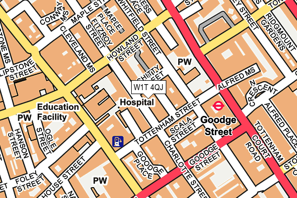
W1T 4QJ is located in the Bloomsbury electoral ward, within the London borough of Camden and the English Parliamentary constituency of Holborn and St Pancras. The Sub Integrated Care Board (ICB) Location is NHS North Central London ICB - 93C and the police force is Metropolitan Police. This postcode has been in use since December 2000.


GetTheData
Source: OS OpenMap – Local (Ordnance Survey)
Source: OS VectorMap District (Ordnance Survey)
Licence: Open Government Licence (requires attribution)
| Easting | 529375 |
| Northing | 181837 |
| Latitude | 51.520643 |
| Longitude | -0.136680 |
GetTheData
Source: Open Postcode Geo
Licence: Open Government Licence
| Country | England |
| Postcode District | W1T |
➜ See where W1T is on a map ➜ Where is London? | |
GetTheData
Source: Land Registry Price Paid Data
Licence: Open Government Licence
Elevation or altitude of W1T 4QJ as distance above sea level:
| Metres | Feet | |
|---|---|---|
| Elevation | 30m | 98ft |
Elevation is measured from the approximate centre of the postcode, to the nearest point on an OS contour line from OS Terrain 50, which has contour spacing of ten vertical metres.
➜ How high above sea level am I? Find the elevation of your current position using your device's GPS.
GetTheData
Source: Open Postcode Elevation
Licence: Open Government Licence
| Ward | Bloomsbury |
| Constituency | Holborn And St Pancras |
GetTheData
Source: ONS Postcode Database
Licence: Open Government Licence
| Goodge Street | Goodge Street | 127m |
| Warren Street (Tottenham Court Road) | Warren Street | 282m |
| Percy Street | Fitzrovia | 330m |
| Torrington Place (Gower Street) | Goodge Street | 366m |
| Chenies Street (Gower Street) | Goodge Street | 386m |
| Goodge Street Underground Station | Goodge Street | 161m |
| Warren Street Underground Station | Warren Street | 492m |
| Euston Square Underground Station | Euston Square | 555m |
| Great Portland Street Underground Station | Great Portland Street | 635m |
| Tottenham Court Road Underground Station | Tottenham Court Road | 640m |
| London Euston Station | 0.9km |
| London St Pancras International LL Station | 1.4km |
| London St Pancras International Station | 1.5km |
GetTheData
Source: NaPTAN
Licence: Open Government Licence
GetTheData
Source: ONS Postcode Database
Licence: Open Government Licence


➜ Get more ratings from the Food Standards Agency
GetTheData
Source: Food Standards Agency
Licence: FSA terms & conditions
| Last Collection | |||
|---|---|---|---|
| Location | Mon-Fri | Sat | Distance |
| Charlotte Street | 18:30 | 12:00 | 103m |
| Torrington Place (Tcr) | 18:30 | 12:00 | 152m |
| Chenies Street (Tcr) | 18:30 | 12:00 | 195m |
GetTheData
Source: Dracos
Licence: Creative Commons Attribution-ShareAlike
The below table lists the International Territorial Level (ITL) codes (formerly Nomenclature of Territorial Units for Statistics (NUTS) codes) and Local Administrative Units (LAU) codes for W1T 4QJ:
| ITL 1 Code | Name |
|---|---|
| TLI | London |
| ITL 2 Code | Name |
| TLI3 | Inner London - West |
| ITL 3 Code | Name |
| TLI31 | Camden and City of London |
| LAU 1 Code | Name |
| E09000007 | Camden |
GetTheData
Source: ONS Postcode Directory
Licence: Open Government Licence
The below table lists the Census Output Area (OA), Lower Layer Super Output Area (LSOA), and Middle Layer Super Output Area (MSOA) for W1T 4QJ:
| Code | Name | |
|---|---|---|
| OA | E00174650 | |
| LSOA | E01000851 | Camden 026B |
| MSOA | E02000191 | Camden 026 |
GetTheData
Source: ONS Postcode Directory
Licence: Open Government Licence
| W1T 4QH | Charlotte Street | 16m |
| W1T 4AT | Chitty Street | 22m |
| W1T 4AS | Chitty Street | 32m |
| W1T 4EA | Charlotte Mews | 32m |
| W1T 4QA | Charlotte Street | 39m |
| W1T 4PR | Charlotte Street | 40m |
| W1T 4AG | Tottenham Mews | 46m |
| W1T 4AF | Tottenham Mews | 46m |
| W1T 4AE | Tottenham Mews | 48m |
| W1T 4AQ | Tottenham Mews | 52m |
GetTheData
Source: Open Postcode Geo; Land Registry Price Paid Data
Licence: Open Government Licence