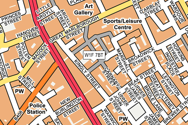
W1F 7BT is located in the West End electoral ward, within the London borough of Westminster and the English Parliamentary constituency of Cities of London and Westminster. The Sub Integrated Care Board (ICB) Location is NHS North West London ICB - W2U3Z and the police force is Metropolitan Police. This postcode has been in use since June 2001.


GetTheData
Source: OS OpenMap – Local (Ordnance Survey)
Source: OS VectorMap District (Ordnance Survey)
Licence: Open Government Licence (requires attribution)
| Easting | 529227 |
| Northing | 180992 |
| Latitude | 51.513083 |
| Longitude | -0.139122 |
GetTheData
Source: Open Postcode Geo
Licence: Open Government Licence
| Country | England |
| Postcode District | W1F |
➜ See where W1F is on a map ➜ Where is City of Westminster? | |
GetTheData
Source: Land Registry Price Paid Data
Licence: Open Government Licence
Elevation or altitude of W1F 7BT as distance above sea level:
| Metres | Feet | |
|---|---|---|
| Elevation | 20m | 66ft |
Elevation is measured from the approximate centre of the postcode, to the nearest point on an OS contour line from OS Terrain 50, which has contour spacing of ten vertical metres.
➜ How high above sea level am I? Find the elevation of your current position using your device's GPS.
GetTheData
Source: Open Postcode Elevation
Licence: Open Government Licence
| Ward | West End |
| Constituency | Cities Of London And Westminster |
GetTheData
Source: ONS Postcode Database
Licence: Open Government Licence
| Conduit Street Hamleys Toy Store | Soho | 97m |
| Conduit Street Hamleys Toy Store | Soho | 108m |
| Conduit Street | Oxford Circus | 181m |
| Beak Street Hamleys Toy Store | Soho | 198m |
| Beak Street Hamleys Toy Store | Soho | 202m |
| Oxford Circus Underground Station | Oxford Circus | 306m |
| Piccadilly Circus Underground Station | Piccadilly Circus | 500m |
| Tottenham Court Road Underground Station | Tottenham Court Road | 710m |
| Green Park Underground Station | Green Park | 729m |
| Bond Street Underground Station | Bond Street | 748m |
| London Charing Cross Station | 1.1km |
| London Euston Station | 1.7km |
| London Marylebone Station | 2km |
GetTheData
Source: NaPTAN
Licence: Open Government Licence
GetTheData
Source: ONS Postcode Database
Licence: Open Government Licence


➜ Get more ratings from the Food Standards Agency
GetTheData
Source: Food Standards Agency
Licence: FSA terms & conditions
| Last Collection | |||
|---|---|---|---|
| Location | Mon-Fri | Sat | Distance |
| Regent Street | 18:30 | 12:00 | 128m |
| Great Marlborough Street | 18:30 | 12:00 | 130m |
| Regent Street | 18:30 | 12:00 | 155m |
GetTheData
Source: Dracos
Licence: Creative Commons Attribution-ShareAlike
The below table lists the International Territorial Level (ITL) codes (formerly Nomenclature of Territorial Units for Statistics (NUTS) codes) and Local Administrative Units (LAU) codes for W1F 7BT:
| ITL 1 Code | Name |
|---|---|
| TLI | London |
| ITL 2 Code | Name |
| TLI3 | Inner London - West |
| ITL 3 Code | Name |
| TLI32 | Westminster |
| LAU 1 Code | Name |
| E09000033 | Westminster |
GetTheData
Source: ONS Postcode Directory
Licence: Open Government Licence
The below table lists the Census Output Area (OA), Lower Layer Super Output Area (LSOA), and Middle Layer Super Output Area (MSOA) for W1F 7BT:
| Code | Name | |
|---|---|---|
| OA | E00024110 | |
| LSOA | E01033596 | Westminster 013F |
| MSOA | E02000972 | Westminster 013 |
GetTheData
Source: ONS Postcode Directory
Licence: Open Government Licence
| W1F 7QY | Ganton Street | 21m |
| W1B 5QP | Kingly Street | 38m |
| W1F 9PF | Carnaby Street | 46m |
| W1F 7RB | Newburgh Street | 58m |
| W1F 7RW | Newburgh Street | 71m |
| W1F 9QZ | Broadwick Street | 71m |
| W1B 5TH | Regent Street | 82m |
| W1F 9BE | Marshall Street | 93m |
| W1F 9QT | Broadwick Street | 98m |
| W1F 7ER | Marshall Street | 107m |
GetTheData
Source: Open Postcode Geo; Land Registry Price Paid Data
Licence: Open Government Licence