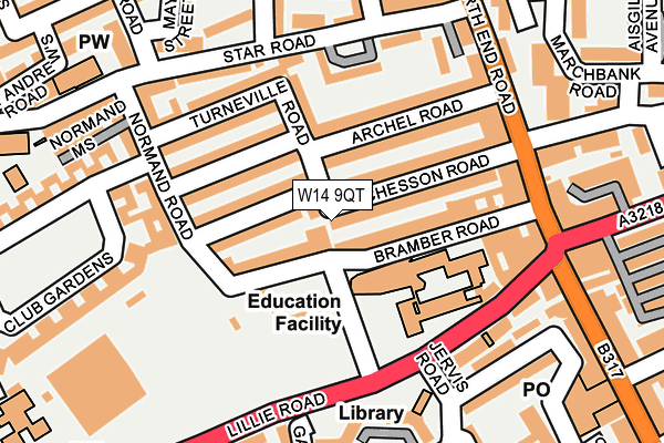
W14 9QT is located in the West Kensington electoral ward, within the London borough of Hammersmith and Fulham and the English Parliamentary constituency of Hammersmith. The Sub Integrated Care Board (ICB) Location is NHS North West London ICB - W2U3Z and the police force is Metropolitan Police. This postcode has been in use since January 1980.


GetTheData
Source: OS OpenMap – Local (Ordnance Survey)
Source: OS VectorMap District (Ordnance Survey)
Licence: Open Government Licence (requires attribution)
| Easting | 524699 |
| Northing | 177837 |
| Latitude | 51.485745 |
| Longitude | -0.205453 |
GetTheData
Source: Open Postcode Geo
Licence: Open Government Licence
| Country | England |
| Postcode District | W14 |
➜ See where W14 is on a map ➜ Where is Kensington? | |
GetTheData
Source: Land Registry Price Paid Data
Licence: Open Government Licence
Elevation or altitude of W14 9QT as distance above sea level:
| Metres | Feet | |
|---|---|---|
| Elevation | 0m | 0ft |
Elevation is measured from the approximate centre of the postcode, to the nearest point on an OS contour line from OS Terrain 50, which has contour spacing of ten vertical metres.
➜ How high above sea level am I? Find the elevation of your current position using your device's GPS.
GetTheData
Source: Open Postcode Elevation
Licence: Open Government Licence
| Ward | West Kensington |
| Constituency | Hammersmith |
GetTheData
Source: ONS Postcode Database
Licence: Open Government Licence
| Mulgrave Road Fulham (Lillie Road) | West Kensington | 143m |
| Mulgrave Road Fulham (Lillie Road) | West Kensington | 171m |
| Lillie Road West Kensington (North End Road) | West Kensington | 191m |
| Lillie Road West Kensington (North End Road) | West Kensington | 243m |
| North End Road Lillie Road (Lillie Road) | West Kensington | 260m |
| West Kensington Underground Station | West Kensington | 531m |
| West Brompton Underground Station | West Brompton | 705m |
| Barons Court Underground Station | Barons Court | 751m |
| Fulham Broadway Underground Station | Fulham Broadway | 940m |
| Earl's Court Underground Station | Earls Court | 1,094m |
| West Brompton Station | 0.7km |
| Kensington (Olympia) Station | 1.4km |
| Imperial Wharf Station | 2km |
GetTheData
Source: NaPTAN
Licence: Open Government Licence
GetTheData
Source: ONS Postcode Database
Licence: Open Government Licence


➜ Get more ratings from the Food Standards Agency
GetTheData
Source: Food Standards Agency
Licence: FSA terms & conditions
| Last Collection | |||
|---|---|---|---|
| Location | Mon-Fri | Sat | Distance |
| Archel Road | 17:30 | 12:00 | 109m |
| Post Office | 17:30 | 12:00 | 149m |
| Normand Road | 17:30 | 12:00 | 172m |
GetTheData
Source: Dracos
Licence: Creative Commons Attribution-ShareAlike
| Risk of W14 9QT flooding from rivers and sea | Very Low |
| ➜ W14 9QT flood map | |
GetTheData
Source: Open Flood Risk by Postcode
Licence: Open Government Licence
The below table lists the International Territorial Level (ITL) codes (formerly Nomenclature of Territorial Units for Statistics (NUTS) codes) and Local Administrative Units (LAU) codes for W14 9QT:
| ITL 1 Code | Name |
|---|---|
| TLI | London |
| ITL 2 Code | Name |
| TLI3 | Inner London - West |
| ITL 3 Code | Name |
| TLI33 | Kensington & Chelsea and Hammersmith & Fulham |
| LAU 1 Code | Name |
| E09000013 | Hammersmith and Fulham |
GetTheData
Source: ONS Postcode Directory
Licence: Open Government Licence
The below table lists the Census Output Area (OA), Lower Layer Super Output Area (LSOA), and Middle Layer Super Output Area (MSOA) for W14 9QT:
| Code | Name | |
|---|---|---|
| OA | E00009544 | |
| LSOA | E01001909 | Hammersmith and Fulham 015C |
| MSOA | E02000386 | Hammersmith and Fulham 015 |
GetTheData
Source: ONS Postcode Directory
Licence: Open Government Licence
| W14 9PB | Bramber Road | 30m |
| W14 9QS | Chesson Road | 60m |
| W14 9QU | Chesson Road | 79m |
| W14 9QX | Chesson Road | 81m |
| W14 9QR | Chesson Road | 81m |
| W14 9QL | Archel Road | 97m |
| W14 9QJ | Archel Road | 97m |
| W14 9PT | Normand Road | 105m |
| W14 9QP | Archel Road | 112m |
| W14 9QH | Archel Road | 115m |
GetTheData
Source: Open Postcode Geo; Land Registry Price Paid Data
Licence: Open Government Licence