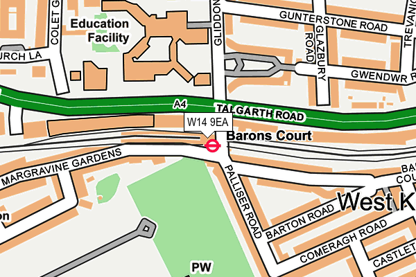
W14 9EA is located in the Hammersmith Broadway electoral ward, within the London borough of Hammersmith and Fulham and the English Parliamentary constituency of Hammersmith. The Sub Integrated Care Board (ICB) Location is NHS North West London ICB - W2U3Z and the police force is Metropolitan Police. This postcode has been in use since January 1980.


GetTheData
Source: OS OpenMap – Local (Ordnance Survey)
Source: OS VectorMap District (Ordnance Survey)
Licence: Open Government Licence (requires attribution)
| Easting | 524127 |
| Northing | 178330 |
| Latitude | 51.490302 |
| Longitude | -0.213514 |
GetTheData
Source: Open Postcode Geo
Licence: Open Government Licence
| Country | England |
| Postcode District | W14 |
➜ See where W14 is on a map ➜ Where is Hammersmith? | |
GetTheData
Source: Land Registry Price Paid Data
Licence: Open Government Licence
Elevation or altitude of W14 9EA as distance above sea level:
| Metres | Feet | |
|---|---|---|
| Elevation | 0m | 0ft |
Elevation is measured from the approximate centre of the postcode, to the nearest point on an OS contour line from OS Terrain 50, which has contour spacing of ten vertical metres.
➜ How high above sea level am I? Find the elevation of your current position using your device's GPS.
GetTheData
Source: Open Postcode Elevation
Licence: Open Government Licence
| Ward | Hammersmith Broadway |
| Constituency | Hammersmith |
GetTheData
Source: ONS Postcode Database
Licence: Open Government Licence
| Barons Court | Barons Court | 46m |
| Barons Court | Barons Court | 61m |
| Brook Green (Hammersmith Road) | Brook Green | 384m |
| Brook Green (Hammersmith Road) | Brook Green | 436m |
| Lytton Estate (North End Road) | West Kensington | 465m |
| Barons Court Underground Station | Barons Court | 6m |
| West Kensington Underground Station | West Kensington | 478m |
| Hammersmith (Dist&picc Line) Underground Station | Hammersmith | 736m |
| Kensington (Olympia) Underground Station | Olympia | 850m |
| Hammersmith (H&c Line) Underground Station | Hammersmith | 876m |
| Kensington (Olympia) Station | 0.9km |
| West Brompton Station | 1.3km |
| Shepherds Bush Station | 1.7km |
GetTheData
Source: NaPTAN
Licence: Open Government Licence
GetTheData
Source: ONS Postcode Database
Licence: Open Government Licence


➜ Get more ratings from the Food Standards Agency
GetTheData
Source: Food Standards Agency
Licence: FSA terms & conditions
| Last Collection | |||
|---|---|---|---|
| Location | Mon-Fri | Sat | Distance |
| Barons Court Station (Lul) | 18:30 | 12:00 | 15m |
| Gliddon Road | 17:30 | 12:00 | 199m |
| Margravine Gardens | 17:30 | 12:00 | 221m |
GetTheData
Source: Dracos
Licence: Creative Commons Attribution-ShareAlike
| Risk of W14 9EA flooding from rivers and sea | Very Low |
| ➜ W14 9EA flood map | |
GetTheData
Source: Open Flood Risk by Postcode
Licence: Open Government Licence
The below table lists the International Territorial Level (ITL) codes (formerly Nomenclature of Territorial Units for Statistics (NUTS) codes) and Local Administrative Units (LAU) codes for W14 9EA:
| ITL 1 Code | Name |
|---|---|
| TLI | London |
| ITL 2 Code | Name |
| TLI3 | Inner London - West |
| ITL 3 Code | Name |
| TLI33 | Kensington & Chelsea and Hammersmith & Fulham |
| LAU 1 Code | Name |
| E09000013 | Hammersmith and Fulham |
GetTheData
Source: ONS Postcode Directory
Licence: Open Government Licence
The below table lists the Census Output Area (OA), Lower Layer Super Output Area (LSOA), and Middle Layer Super Output Area (MSOA) for W14 9EA:
| Code | Name | |
|---|---|---|
| OA | E00009437 | |
| LSOA | E01001889 | Hammersmith and Fulham 014A |
| MSOA | E02000385 | Hammersmith and Fulham 014 |
GetTheData
Source: ONS Postcode Directory
Licence: Open Government Licence
| W14 9DA | Talgarth Road | 41m |
| W14 9DF | Talgarth Road | 65m |
| W14 9ED | Palliser Road | 81m |
| W14 9DX | Barons Court Road | 100m |
| W14 9AX | Barons Keep | 107m |
| W6 8RL | Margravine Gardens | 109m |
| W14 9EE | Palliser Road | 114m |
| W14 9DZ | Barons Court Road | 131m |
| W14 9AT | Barons Keep | 142m |
| W14 9EB | Palliser Road | 146m |
GetTheData
Source: Open Postcode Geo; Land Registry Price Paid Data
Licence: Open Government Licence