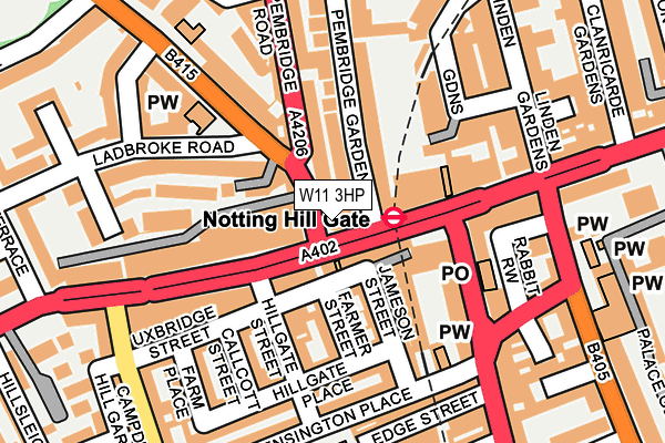
W11 3HP lies on Notting Hill Gate in London. W11 3HP is located in the Pembridge electoral ward, within the London borough of Kensington and Chelsea and the English Parliamentary constituency of Kensington. The Sub Integrated Care Board (ICB) Location is NHS North West London ICB - W2U3Z and the police force is Metropolitan Police. This postcode has been in use since January 1980.


GetTheData
Source: OS OpenMap – Local (Ordnance Survey)
Source: OS VectorMap District (Ordnance Survey)
Licence: Open Government Licence (requires attribution)
| Easting | 525233 |
| Northing | 180459 |
| Latitude | 51.509193 |
| Longitude | -0.196812 |
GetTheData
Source: Open Postcode Geo
Licence: Open Government Licence
| Street | Notting Hill Gate |
| Town/City | London |
| Country | England |
| Postcode District | W11 |
➜ See where W11 is on a map ➜ Where is Kensington? | |
GetTheData
Source: Land Registry Price Paid Data
Licence: Open Government Licence
Elevation or altitude of W11 3HP as distance above sea level:
| Metres | Feet | |
|---|---|---|
| Elevation | 30m | 98ft |
Elevation is measured from the approximate centre of the postcode, to the nearest point on an OS contour line from OS Terrain 50, which has contour spacing of ten vertical metres.
➜ How high above sea level am I? Find the elevation of your current position using your device's GPS.
GetTheData
Source: Open Postcode Elevation
Licence: Open Government Licence
| Ward | Pembridge |
| Constituency | Kensington |
GetTheData
Source: ONS Postcode Database
Licence: Open Government Licence
| Notting Hill Gate | Notting Hill | 18m |
| Notting Hill Gate | Notting Hill | 40m |
| Notting Hill Gate Stn Pembridge Road | Notting Hill | 51m |
| Notting Hill Gate | Notting Hill | 63m |
| Notting Hill Gate Hillgate St | Notting Hill | 114m |
| Notting Hill Gate Underground Station | Notting Hill | 51m |
| Holland Park Underground Station | Holland Park | 655m |
| Queensway Underground Station | Queensway | 684m |
| Bayswater Underground Station | Bayswater | 707m |
| High Street Kensington Underground Station | High Street Kensington | 948m |
| Shepherds Bush Station | 1.5km |
| Kensington (Olympia) Station | 1.6km |
| London Paddington Station | 1.6km |
GetTheData
Source: NaPTAN
Licence: Open Government Licence
GetTheData
Source: ONS Postcode Database
Licence: Open Government Licence


➜ Get more ratings from the Food Standards Agency
GetTheData
Source: Food Standards Agency
Licence: FSA terms & conditions
| Last Collection | |||
|---|---|---|---|
| Location | Mon-Fri | Sat | Distance |
| Uxbridge Street | 17:30 | 12:00 | 112m |
| Post Office | 18:30 | 12:00 | 140m |
| Linden Gardens | 18:30 | 12:00 | 162m |
GetTheData
Source: Dracos
Licence: Creative Commons Attribution-ShareAlike
The below table lists the International Territorial Level (ITL) codes (formerly Nomenclature of Territorial Units for Statistics (NUTS) codes) and Local Administrative Units (LAU) codes for W11 3HP:
| ITL 1 Code | Name |
|---|---|
| TLI | London |
| ITL 2 Code | Name |
| TLI3 | Inner London - West |
| ITL 3 Code | Name |
| TLI33 | Kensington & Chelsea and Hammersmith & Fulham |
| LAU 1 Code | Name |
| E09000020 | Kensington and Chelsea |
GetTheData
Source: ONS Postcode Directory
Licence: Open Government Licence
The below table lists the Census Output Area (OA), Lower Layer Super Output Area (LSOA), and Middle Layer Super Output Area (MSOA) for W11 3HP:
| Code | Name | |
|---|---|---|
| OA | E00014483 | |
| LSOA | E01002884 | Kensington and Chelsea 006C |
| MSOA | E02000582 | Kensington and Chelsea 006 |
GetTheData
Source: ONS Postcode Directory
Licence: Open Government Licence
| W11 3JS | Notting Hill Gate | 46m |
| W2 4DU | Pembridge Gardens | 50m |
| W2 4EE | Pembridge Gardens | 51m |
| W11 3HL | Pembridge Road | 53m |
| W11 3QA | Notting Hill Gate | 69m |
| W11 3JZ | Notting Hill Gate | 69m |
| W8 7TG | Uxbridge Street | 72m |
| W11 3HT | Notting Hill Gate | 72m |
| W11 3NZ | Bulmer Mews | 85m |
| W8 7SN | Farmer Street | 90m |
GetTheData
Source: Open Postcode Geo; Land Registry Price Paid Data
Licence: Open Government Licence