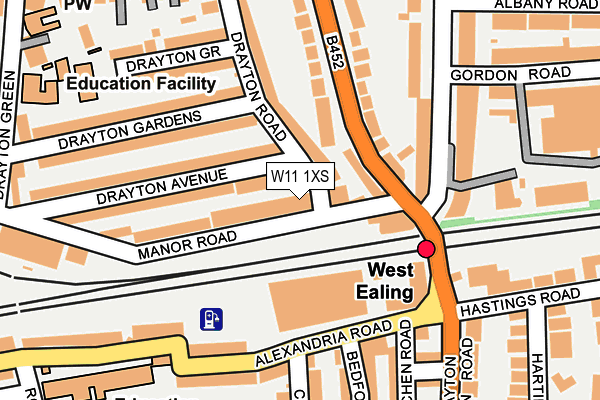
W11 1XS is located in the Pitshanger electoral ward, within the London borough of Ealing and the English Parliamentary constituency of Ealing North. The Sub Integrated Care Board (ICB) Location is NHS North West London ICB - W2U3Z and the police force is Metropolitan Police. This postcode has been in use since May 2006.


GetTheData
Source: OS OpenMap – Local (Ordnance Survey)
Source: OS VectorMap District (Ordnance Survey)
Licence: Open Government Licence (requires attribution)
| Easting | 516561 |
| Northing | 180779 |
| Latitude | 51.513921 |
| Longitude | -0.321631 |
GetTheData
Source: Open Postcode Geo
Licence: Open Government Licence
| Country | England |
| Postcode District | W11 |
➜ See where W11 is on a map ➜ Where is Ealing? | |
GetTheData
Source: Land Registry Price Paid Data
Licence: Open Government Licence
Elevation or altitude of W11 1XS as distance above sea level:
| Metres | Feet | |
|---|---|---|
| Elevation | 30m | 98ft |
Elevation is measured from the approximate centre of the postcode, to the nearest point on an OS contour line from OS Terrain 50, which has contour spacing of ten vertical metres.
➜ How high above sea level am I? Find the elevation of your current position using your device's GPS.
GetTheData
Source: Open Postcode Elevation
Licence: Open Government Licence
| Ward | Pitshanger |
| Constituency | Ealing North |
GetTheData
Source: ONS Postcode Database
Licence: Open Government Licence
| West Ealing (Argyle Road) | West Ealing | 76m |
| West Ealing (Argyle Road) | West Ealing | 98m |
| The Avenue (W13) | West Ealing | 218m |
| Sutherland Avenue (W13) (Argyle Road) | West Ealing | 240m |
| Drayton Green Road | West Ealing | 246m |
| Ealing Broadway Underground Station | Ealing Broadway | 1,405m |
| South Ealing Underground Station | South Ealing | 1,743m |
| West Ealing Station | 0.1km |
| Drayton Green Station | 0.7km |
| Hanwell Station | 1.2km |
GetTheData
Source: NaPTAN
Licence: Open Government Licence
GetTheData
Source: ONS Postcode Database
Licence: Open Government Licence


➜ Get more ratings from the Food Standards Agency
GetTheData
Source: Food Standards Agency
Licence: FSA terms & conditions
| Last Collection | |||
|---|---|---|---|
| Location | Mon-Fri | Sat | Distance |
| West Ealing Delivery Office | 17:30 | 12:00 | 13m |
| Waldeck Road | 17:30 | 12:00 | 160m |
| Post Office | 17:30 | 12:00 | 193m |
GetTheData
Source: Dracos
Licence: Creative Commons Attribution-ShareAlike
The below table lists the International Territorial Level (ITL) codes (formerly Nomenclature of Territorial Units for Statistics (NUTS) codes) and Local Administrative Units (LAU) codes for W11 1XS:
| ITL 1 Code | Name |
|---|---|
| TLI | London |
| ITL 2 Code | Name |
| TLI7 | Outer London - West and North West |
| ITL 3 Code | Name |
| TLI73 | Ealing |
| LAU 1 Code | Name |
| E09000009 | Ealing |
GetTheData
Source: ONS Postcode Directory
Licence: Open Government Licence
The below table lists the Census Output Area (OA), Lower Layer Super Output Area (LSOA), and Middle Layer Super Output Area (MSOA) for W11 1XS:
| Code | Name | |
|---|---|---|
| OA | E00006040 | |
| LSOA | E01001207 | Ealing 018D |
| MSOA | E02000255 | Ealing 018 |
GetTheData
Source: ONS Postcode Directory
Licence: Open Government Licence
| W13 0LH | Manor Road | 40m |
| W13 0LN | Argyle Road | 67m |
| W13 0LJ | Manor Road | 84m |
| W13 8AB | Argyle Road | 106m |
| W13 0LD | Drayton Road | 108m |
| W13 0LE | Drayton Avenue | 121m |
| W13 8JP | Castle Hill Parade | 127m |
| W13 0JA | Manor Road | 134m |
| W13 0NW | Drayton Green Road | 147m |
| W13 0LF | Drayton Avenue | 154m |
GetTheData
Source: Open Postcode Geo; Land Registry Price Paid Data
Licence: Open Government Licence