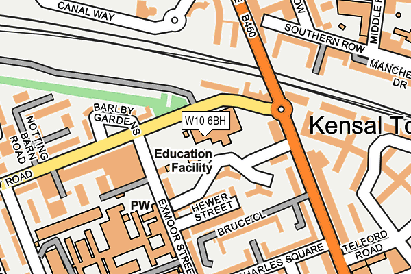
W10 6BH is located in the Dalgarno electoral ward, within the London borough of Kensington and Chelsea and the English Parliamentary constituency of Kensington. The Sub Integrated Care Board (ICB) Location is NHS North West London ICB - W2U3Z and the police force is Metropolitan Police. This postcode has been in use since January 1980.


GetTheData
Source: OS OpenMap – Local (Ordnance Survey)
Source: OS VectorMap District (Ordnance Survey)
Licence: Open Government Licence (requires attribution)
| Easting | 523841 |
| Northing | 182027 |
| Latitude | 51.523591 |
| Longitude | -0.216310 |
GetTheData
Source: Open Postcode Geo
Licence: Open Government Licence
| Country | England |
| Postcode District | W10 |
➜ See where W10 is on a map ➜ Where is Kensington? | |
GetTheData
Source: Land Registry Price Paid Data
Licence: Open Government Licence
Elevation or altitude of W10 6BH as distance above sea level:
| Metres | Feet | |
|---|---|---|
| Elevation | 20m | 66ft |
Elevation is measured from the approximate centre of the postcode, to the nearest point on an OS contour line from OS Terrain 50, which has contour spacing of ten vertical metres.
➜ How high above sea level am I? Find the elevation of your current position using your device's GPS.
GetTheData
Source: Open Postcode Elevation
Licence: Open Government Licence
| Ward | Dalgarno |
| Constituency | Kensington |
GetTheData
Source: ONS Postcode Database
Licence: Open Government Licence
| Barlby Gardens (Barlby Road) | North Kensington | 70m |
| Barlby Gardens (Barlby Road) | North Kensington | 105m |
| Barlby Road (Ladbroke Grove) | Kensal Town | 187m |
| Barlby Road (Ladbroke Grove) | Kensal Town | 200m |
| Ladbroke Grove Sainsbury's (Canal Way) | Kensal Town | 223m |
| Ladbroke Grove Underground Station | Ladbroke Grove | 798m |
| Kensal Green Underground Station | Kensal Green | 980m |
| Westbourne Park Underground Station | Westbourne Park | 1,095m |
| Latimer Road Underground Station | Latimer Road | 1,139m |
| White City Underground Station | White City | 1,407m |
| Kensal Green Station | 1km |
| Kensal Rise Station | 1.2km |
| Queens Park (London) Station | 1.4km |
GetTheData
Source: NaPTAN
Licence: Open Government Licence
GetTheData
Source: ONS Postcode Database
Licence: Open Government Licence


➜ Get more ratings from the Food Standards Agency
GetTheData
Source: Food Standards Agency
Licence: FSA terms & conditions
| Last Collection | |||
|---|---|---|---|
| Location | Mon-Fri | Sat | Distance |
| Saint Charles Hospital | 17:30 | 12:00 | 180m |
| Ladbroke Grove | 17:30 | 12:00 | 322m |
| Kensal Road | 17:30 | 12:00 | 336m |
GetTheData
Source: Dracos
Licence: Creative Commons Attribution-ShareAlike
The below table lists the International Territorial Level (ITL) codes (formerly Nomenclature of Territorial Units for Statistics (NUTS) codes) and Local Administrative Units (LAU) codes for W10 6BH:
| ITL 1 Code | Name |
|---|---|
| TLI | London |
| ITL 2 Code | Name |
| TLI3 | Inner London - West |
| ITL 3 Code | Name |
| TLI33 | Kensington & Chelsea and Hammersmith & Fulham |
| LAU 1 Code | Name |
| E09000020 | Kensington and Chelsea |
GetTheData
Source: ONS Postcode Directory
Licence: Open Government Licence
The below table lists the Census Output Area (OA), Lower Layer Super Output Area (LSOA), and Middle Layer Super Output Area (MSOA) for W10 6BH:
| Code | Name | |
|---|---|---|
| OA | E00014621 | |
| LSOA | E01002905 | Kensington and Chelsea 002B |
| MSOA | E02000578 | Kensington and Chelsea 002 |
GetTheData
Source: ONS Postcode Directory
Licence: Open Government Licence
| W10 6BB | Exmoor Street | 61m |
| W10 6BG | Treverton Street | 95m |
| W10 5LW | Barlby Gardens | 99m |
| W10 6DU | Hewer Street | 102m |
| W10 6BF | Exmoor Street | 107m |
| W10 6BA | Exmoor Street | 125m |
| W10 6DR | Barlby Road | 131m |
| W10 5LN | Barlby Road | 132m |
| W10 6BQ | Treverton Street | 148m |
| W10 5YL | Matthew Close | 156m |
GetTheData
Source: Open Postcode Geo; Land Registry Price Paid Data
Licence: Open Government Licence