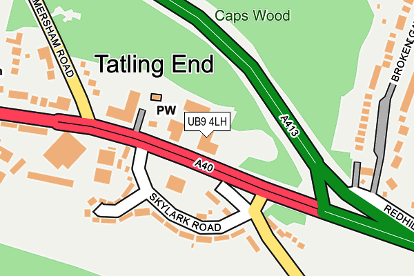
UB9 4LH lies on Capswood Business Centre in Denham, Uxbridge. UB9 4LH is located in the Denham electoral ward, within the unitary authority of Buckinghamshire and the English Parliamentary constituency of Beaconsfield. The Sub Integrated Care Board (ICB) Location is NHS Buckinghamshire, Oxfordshire and Berkshire West ICB - 14Y and the police force is Thames Valley. This postcode has been in use since August 1992.


GetTheData
Source: OS OpenMap – Local (Ordnance Survey)
Source: OS VectorMap District (Ordnance Survey)
Licence: Open Government Licence (requires attribution)
| Easting | 502118 |
| Northing | 187112 |
| Latitude | 51.573639 |
| Longitude | -0.527835 |
GetTheData
Source: Open Postcode Geo
Licence: Open Government Licence
| Street | Capswood Business Centre |
| Locality | Denham |
| Town/City | Uxbridge |
| Country | England |
| Postcode District | UB9 |
➜ See where UB9 is on a map ➜ Where is Tatling End? | |
GetTheData
Source: Land Registry Price Paid Data
Licence: Open Government Licence
Elevation or altitude of UB9 4LH as distance above sea level:
| Metres | Feet | |
|---|---|---|
| Elevation | 70m | 230ft |
Elevation is measured from the approximate centre of the postcode, to the nearest point on an OS contour line from OS Terrain 50, which has contour spacing of ten vertical metres.
➜ How high above sea level am I? Find the elevation of your current position using your device's GPS.
GetTheData
Source: Open Postcode Elevation
Licence: Open Government Licence
| Ward | Denham |
| Constituency | Beaconsfield |
GetTheData
Source: ONS Postcode Database
Licence: Open Government Licence
| The Ugly Duckling Ph (Oxford Road) | Tatling End | 88m |
| The Ugly Duckling Ph (Oxford Road) | Tatling End | 110m |
| Post Office (Oxford Road) | Tatling End | 234m |
| Post Office (Oxford Road) | Tatling End | 334m |
| Mount Lane (Oxford Road) | Tatling End | 560m |
| Denham Golf Club Station | 1km |
| Denham Station | 2.2km |
| Gerrards Cross Station | 2.6km |
GetTheData
Source: NaPTAN
Licence: Open Government Licence
GetTheData
Source: ONS Postcode Database
Licence: Open Government Licence


➜ Get more ratings from the Food Standards Agency
GetTheData
Source: Food Standards Agency
Licence: FSA terms & conditions
| Last Collection | |||
|---|---|---|---|
| Location | Mon-Fri | Sat | Distance |
| Woodside Reach | 16:45 | 12:00 | 485m |
| Over The Misbourne | 16:15 | 12:00 | 1,524m |
| Dukes Wood Drive | 17:15 | 12:00 | 2,086m |
GetTheData
Source: Dracos
Licence: Creative Commons Attribution-ShareAlike
The below table lists the International Territorial Level (ITL) codes (formerly Nomenclature of Territorial Units for Statistics (NUTS) codes) and Local Administrative Units (LAU) codes for UB9 4LH:
| ITL 1 Code | Name |
|---|---|
| TLJ | South East (England) |
| ITL 2 Code | Name |
| TLJ1 | Berkshire, Buckinghamshire and Oxfordshire |
| ITL 3 Code | Name |
| TLJ13 | Buckinghamshire |
| LAU 1 Code | Name |
| E06000060 | Buckinghamshire |
GetTheData
Source: ONS Postcode Directory
Licence: Open Government Licence
The below table lists the Census Output Area (OA), Lower Layer Super Output Area (LSOA), and Middle Layer Super Output Area (MSOA) for UB9 4LH:
| Code | Name | |
|---|---|---|
| OA | E00089904 | |
| LSOA | E01017818 | South Bucks 002A |
| MSOA | E02003689 | South Bucks 002 |
GetTheData
Source: ONS Postcode Directory
Licence: Open Government Licence
| SL9 7AS | Oxford Road | 43m |
| UB9 4HS | Skylark Road | 127m |
| SL9 7BB | Oxford Road | 143m |
| SL9 7BG | Old Amersham Road | 145m |
| UB9 4HR | Skylark Road | 153m |
| UB9 4HH | Hollybush Lane | 182m |
| SL9 7AP | Oxford Road | 214m |
| SL9 7BE | Old Amersham Road | 229m |
| SL9 7AZ | Oxford Road | 251m |
| SL9 7AX | Fulmer Corner | 283m |
GetTheData
Source: Open Postcode Geo; Land Registry Price Paid Data
Licence: Open Government Licence